On this page:
Latest information about where, when and why environmental water may be delivered to the Maribyrnong system and the environmental objectives being targeted is available in this year’s seasonal watering plan.
The seasonal watering plan also contains information about how environmental flows could support cultural, social, recreational and economic values in the Maribyrnong system.
Watering data for the Maribyrnong system and the wider central region is updated quarterly. Visit current watering releases to find out more.
The VEWH does not hold an environmental entitlement in the Maribyrnong system.
Information about the ownership of water entitlements in the Maribyrnong system can be found under the Entitlements and Compliance section of the Maribyrnong basin page at Victorian Water Accounts.
Waterway manager
Storage manager
Environmental Water Holder
Not applicable
Traditional Owners
Bunurong Land Council Aboriginal Corporation - statutory authority for the management of Aboriginal heritage values and culture, under the Victorian Aboriginal Heritage Act 2006.
Wurundjeri Woi-Wurrung Cultural Heritage Aboriginal Corporation - statutory authority for the management of Aboriginal heritage values and culture, under the Victorian Aboriginal Heritage Act 2006.
System overview
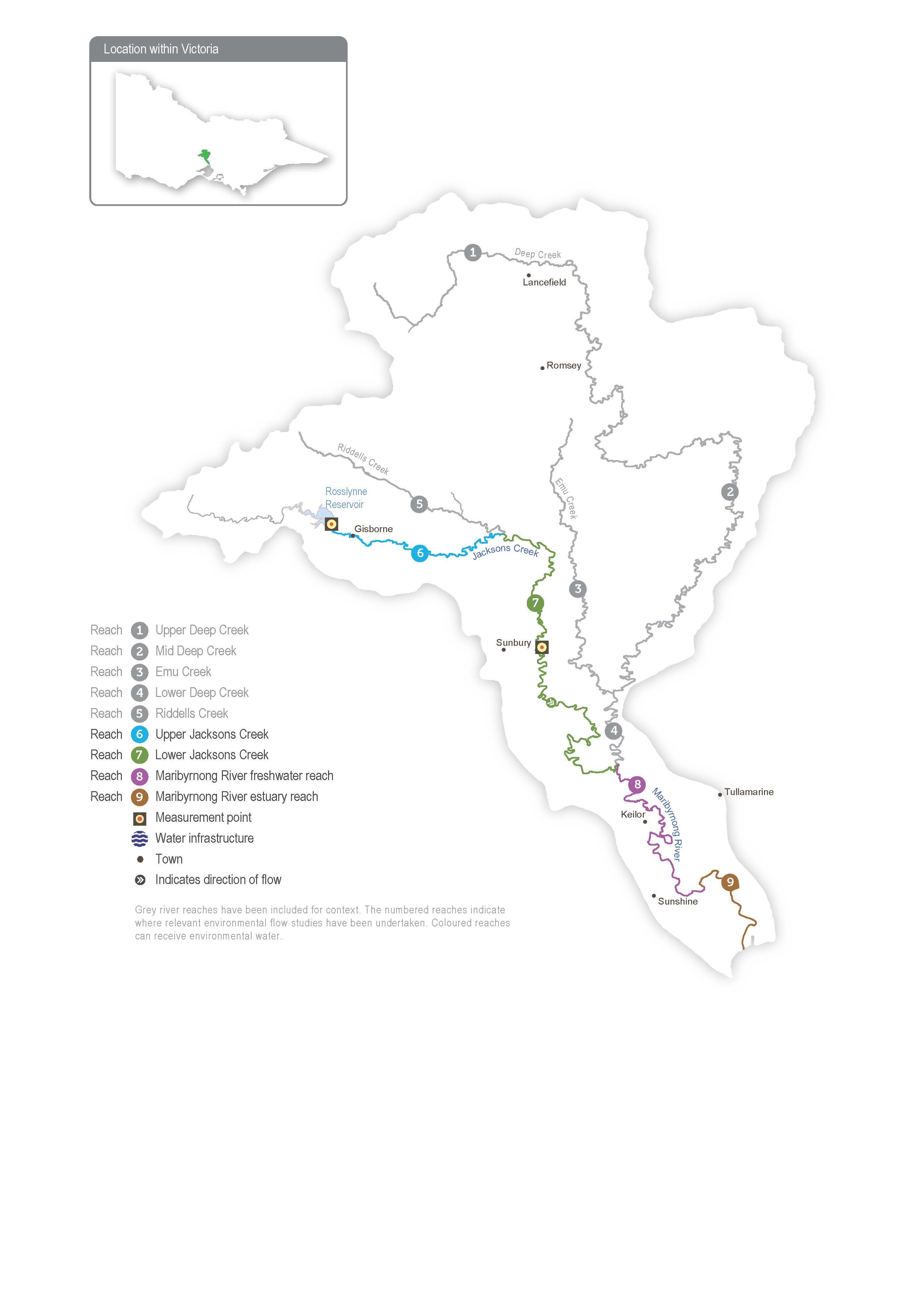
The Maribyrnong catchment is located to the northwest of Melbourne. The main waterways in the catchment are Jacksons Creek, which flows southeast from Mount Macedon, and Deep Creek, which flows south from Lancefield. These tributaries join at Keilor North to form Mirrangbamurn (Maribyrnong River), which flows south to join Birrarung (Yarra River) at Yarraville before flowing into Port Phillip Bay.
Rosslynne Reservoir is in the upper reaches of Jacksons Creek near Gisborne and is the only major storage in the Maribyrnong catchment. The reservoir has a maximum release capacity of 20 ML per day in ideal conditions, which significantly constrains the environmental outcomes that can be achieved in the Maribyrnong system. Water for the environment is primarily used to support environmental outcomes in Jacksons Creek between Rosslynne Reservoir and the confluence with Riddles Creek (that is, delivery of water for the environment to reach 6). Jacksons Creek is a known groundwater-dependent ecosystem on the national Groundwater Dependent Ecosystems Atlas and a priority groundwater-dependent ecosystem in the Melbourne Water groundwater-dependent ecosystem program. This means environmental components in the system rely on groundwater at least some of the time.
The VEWH does not hold an environmental entitlement in the Maribyrnong system, and it relies on opportunistic, temporary trade to meet demands. Melbourne Water (as diversion manager) and the VEWH work with local diversion licence holders to purchase unused water when it is available to support environmental outcomes. This arrangement is negotiated each year, is subject to water availability in the bulk entitlement and storage capacity, and only occurs with all parties’ agreement.
Environmental values
The upper Maribyrnong catchment contains areas of intact streamside vegetation, which provide important habitat for native fish, including migratory short-finned eels, common and ornate galaxias, flathead gudgeon, tupong and Australian smelt.
A diverse and abundant waterbug community provides food for a significant platypus population in several reaches of the Maribyrnong system.
Page last updated: 01/05/25
