On this page:
Latest information about where, when and why environmental water may be delivered to the upper Barwon River and the environmental objectives being targeted is available in this year’s seasonal watering plan.
The seasonal watering plan also contains information about how environmental flows could support cultural, social, recreational and economic values in the upper Barwon River.
Watering data for the upper Barwon River and the wider central region is updated quarterly. Visit current watering releases to find out more.
To find out the current environmental water entitlements held by the VEWH in the upper Barwon River visit our water holdings.
Information about the ownership of water entitlements in the upper Barwon River can be found under the Entitlements and Compliance section of the Barwon basin page at Victorian Water Accounts.
Waterway manager
Corangamite Catchment Management Authority
Melbourne Water
Storage manager
Environmental Water Holder
Victorian Environmental Water Holder
Traditional Owners
Eastern Maar Aboriginal Corporation - statutory authority for the management of Aboriginal heritage values and culture, under the Victorian Aboriginal Heritage Act 2006.
Wadawarrung Traditional Owners Aboriginal Corporation - statutory authority for the management of Aboriginal heritage values and culture, under the Victorian Aboriginal Heritage Act 2006.
System overview
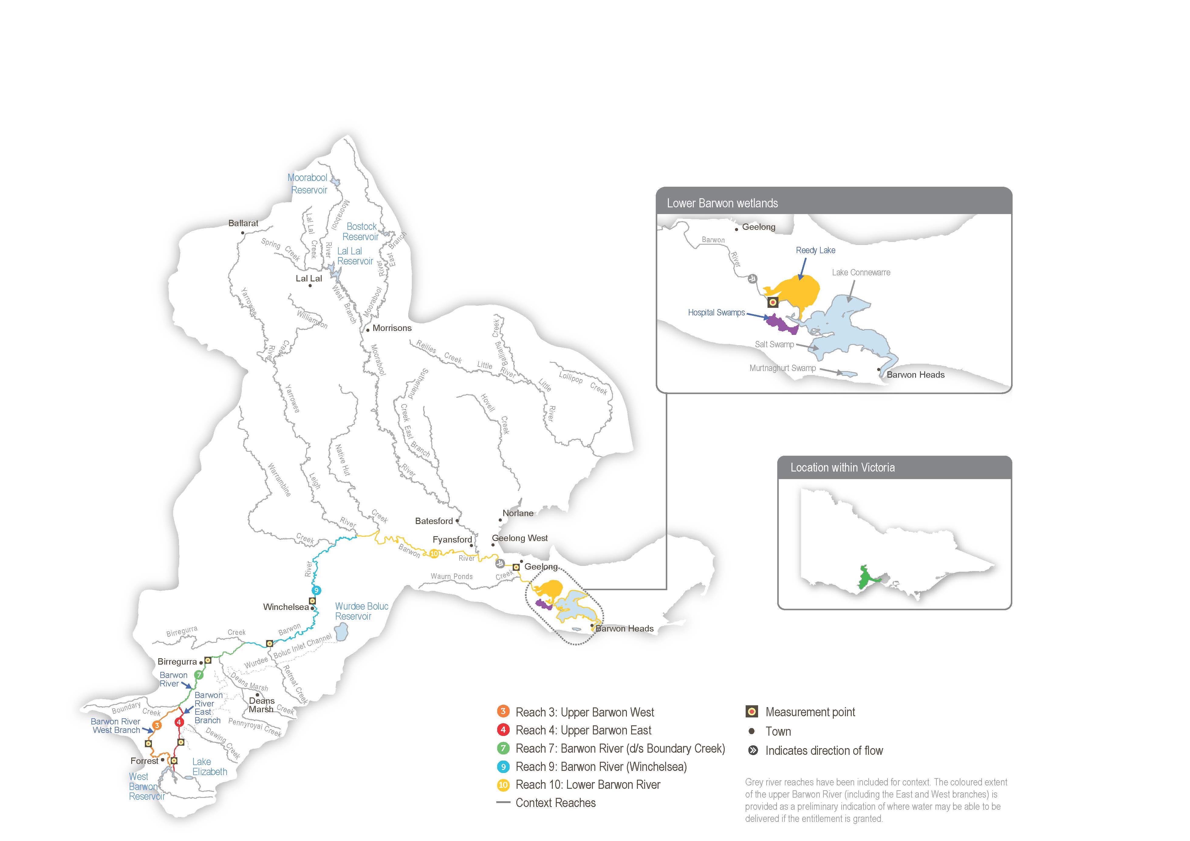
The Barwon system includes the upper Barwon River and lower Barwon wetlands.
The Barwon River flows east from the Otway Ranges, passing the towns of Forrest, Birregurra, Winchelsea, Inverleigh and the City of Geelong before discharging into Bass Strait at Barwon Heads. The Leigh and Moorabool rivers are major tributaries, joining the Barwon River at Inverleigh and Fyansford, respectively. Other tributaries, including Birregurra, Boundary, Callahan, Dewing, Matthews, Pennyroyal, Deans Marsh and Gosling creeks, flow into the Barwon River above Winchelsea. The main storages in the Barwon River catchments are the West Barwon and Wurdee Boluc reservoirs.
The Barwon estuary contains a Ramsar-listed system of wetlands and lakes collectively called the lower Barwon wetlands. Water for the environment can be used to manage the flow in the upper Barwon River and manage water levels in Reedy Lake and Hospital Swamps, which connect to the lower Barwon River.
The operation of the West Barwon Reservoir regulates flows in the upper Barwon River. Water can be released directly from the reservoir into the west or east branches via a diversion tunnel. The junction of the two branches is near Boundary Creek. Downstream of the reservoir, operational water can be diverted into the Wurdee Boluc inlet channel, a 57 km concrete-lined channel that transfers water to Wurdee Boluc Reservoir.
Barwon Water releases passing flow in the order of 1-5 ML per day in both the upper east and west branches from the West Barwon Reservoir. These releases may increase to 15 ML per day in September in a wet year. When the West Barwon and Wurdee Boluc reservoirs collectively hold more than 40,000 ML, all the natural flow is passed down the east branch between January and March. Flood spills from the reservoir and natural inflows from unregulated and regulated tributaries add to the passing flow in the west branch. Regulated and unregulated tributaries add to the passing flow in the east branch.
The Upper Barwon River Environmental Entitlement 2018 enables water for the environment to be made available from the West Barwon Reservoir. The entitlement provides an average of 1,000 ML per year and up to 2,000 ML of the total storage capacity at full supply. Water for the environment was first delivered to the upper Barwon River in 2018-19. The current entitlement provides only enough water to meet the highest-priority potential environmental watering actions in the upper Barwon east branch (reach 4) and the upper Barwon west branch (reach 3) in particular climatic conditions.
Environmental values
The upper Barwon River is home to platypus and native fish species, including the river blackfish, short-finned eel, southern pygmy perch, Australian smelt and various galaxias. The system retains some submerged aquatic vegetation, undercut banks, overhanging vegetation and riffle-pool sequences, which provide essential habitat for fish and other aquatic animals.
Long-term environmental objectives for the upper Barwon system are based on delivering watering actions recommended in the Upper Barwon, Yarrowee and Leigh rivers FLOWS study. These include improving the breeding and recruitment of various fish, platypus and macroinvertebrate species, as well as improving the condition, extent and diversity of in-stream, emergent, streamside and floodplain vegetation. However, due to the limited size of the environmental entitlement and channel constrictions, the flow magnitudes for the potential watering actions described in this plan have been adjusted to be less than the known channel constraints. The watering actions presented in this plan aim to maintain rather than improve current ecological conditions within the upper Barwon River. Significant improvements in ecological condition are unlikely until complementary actions are taken to address channel constraints and other factors (such as unrestricted livestock access and weed infestation).
Page last updated: 01/05/25
