On this page:
Latest information about where, when and why environmental water may be delivered to the Werribee system and the environmental objectives being targeted is available in this year’s seasonal watering plan.
The seasonal watering plan also contains information about how environmental flows could support cultural, social, recreational and economic values in the Werribee system.
Watering data for the Werribee system and the wider central region is updated quarterly. Visit current watering releases to find out more.
To find out the current environmental water entitlements held by the VEWH in the Werribee system visit our water holdings.
Information about the ownership of water entitlements in the Werribee system can be found under the Entitlements and Compliance section of the Werribee basin page at Victorian Water Accounts.
Waterway manager
Storage manager
Environmental Water Holder
Victorian Environmental Water Holder
Traditional Owners
Bunurong Land Council Aboriginal Corporation - statutory authority for the management of Aboriginal heritage values and culture, under the Victorian Aboriginal Heritage Act 2006.
Wurundjeri Woi-Wurrung Cultural Heritage Aboriginal Corporation - statutory authority for the management of Aboriginal heritage values and culture, under the Victorian Aboriginal Heritage Act 2006.
Wadawurrung Traditional Owners Aboriginal Corporation - statutory authority for the management of Aboriginal heritage values and culture, under the Victorian Aboriginal Heritage Act 2006.
System overview
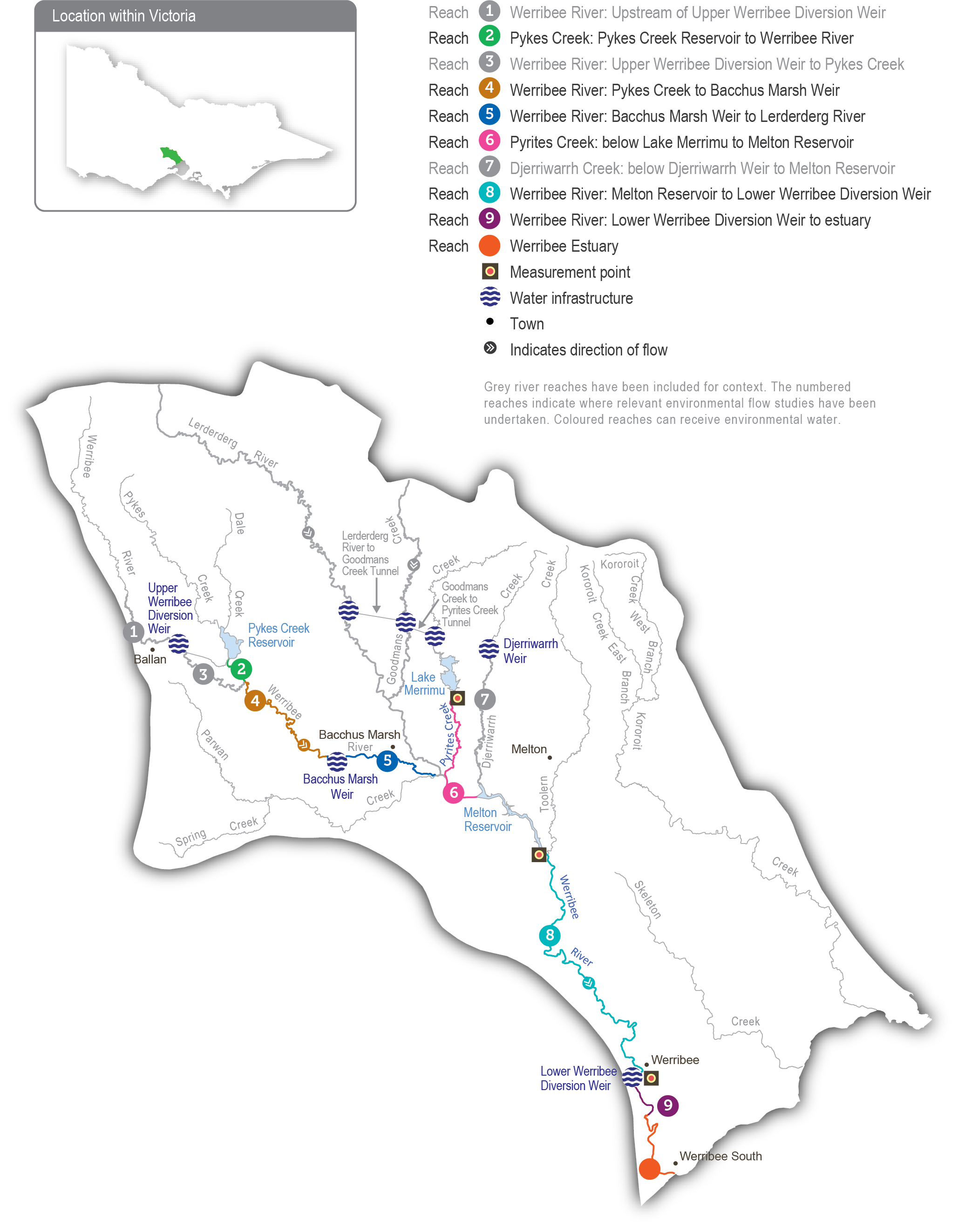
The Werribee River flows southeast from the Wombat State Forest near Ballan, through the Werribee Gorge to Bacchus Marsh and into Port Phillip Bay at Werribee. The Lerderderg River is a major tributary that joins the river at Bacchus Marsh. The main storages in the Werribee system are Pykes Creek Reservoir, Melton Reservoir and Merrimu Reservoir.
The four reaches in the Werribee system that can receive water for the environment are Pyrites Creek between Lake Merrimu and Melton Reservoir (reach 6), the Werribee River between Melton Reservoir and the Werribee Diversion Weir (reach 8), Werribee River between the Werribee Diversion Weir and Werribee Park Tourism Precinct (reach 9) and the Werribee River estuary below the Werribee Park Tourism Precinct.
Environmental flows that target environmental objectives in reach 9 and the estuary are delivered from Melton Reservoir and therefore also benefit reach 8. Water for the environment released from Lake Merrimu is re-harvested in Melton Reservoir, where it can be held and released at an appropriate time to achieve environmental objectives in the lower Werribee River.
Environmental values
The Werribee system supports a range of native fish, including Australian grayling, river blackfish, flathead gudgeon, short-finned eel, tupong, Australian smelt, several species of galaxiids and a large black bream population in the estuary. Several species of frogs, a diverse waterbug community and platypus inhabit the upper and lower reaches. The freshwater-saltwater interface of the Werribee River estuary is a regionally significant ecosystem due to the many aquatic plants and animals it supports, and it provides a nursery habitat for juvenile freshwater and estuarine fish species (such as black bream).
Page last updated: 29/07/25
