On this page:
Latest information about where, when and why environmental water may be delivered to the Latrobe River and the environmental objectives being targeted is available in this year’s seasonal watering plan.
The seasonal watering plan also contains information about how environmental flows could support cultural, social, recreational and economic values in the Latrobe River.
Watering data for the Latrobe River and the wider Gippsland region is updated quarterly. Visit current watering releases to find out more.
To find out the current environmental water entitlements held by the VEWH in the Latrobe River visit our water holdings.
Information about the ownership of water entitlements in the Latrobe River can be found under the Entitlements and Compliance section of the Latrobe basin page at Victorian Water Accounts.
Waterway manager
West Gippsland Catchment Management Authority
Storage manager
Environmental Water Holder
Victorian Environmental Water Holder
Traditional Owners
Gunaikurnai Land and Waters Aboriginal Corporation holds native title, has a Recognition and Settlement Agreement with the Victorian Government, and is the statutory authority for the management of Aboriginal heritage values and culture, under the Victorian Aboriginal Heritage Act 2006.
System overview
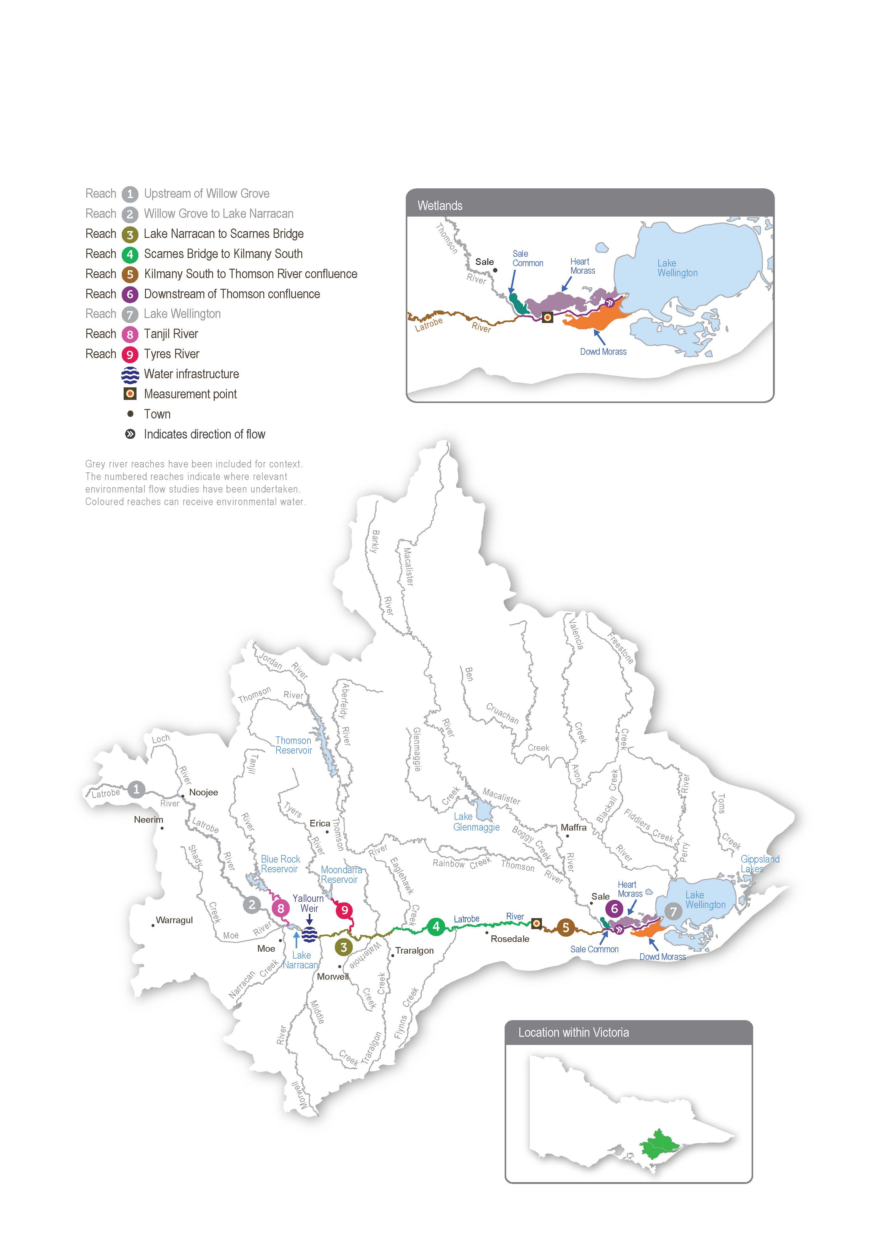
The Latrobe system includes Durt-Yowan (Latrobe River) and lower Latrobe wetlands: Sale Common, Heart Morass and Dowd Morass.
Durt-Yowan (Latrobe River) originates near the Baw Baw Plateau and passes through relatively flat to undulating plains, largely cleared for agriculture, before flowing into Lake Wellington (the westernmost point of the Gippsland Lakes). Notable tributaries include the Tanjil River, Narracan Creek, Morwell River, Tyers River, Traralgon Creek and Carran Carran (Thomson River).
Water for the environment is supplied to the Latrobe River from Blue Rock Reservoir on the Tanjil River. Blue Rock Reservoir also supplies water for irrigation, urban supply, electricity generators and a paper mill in the Latrobe Valley.
The Latrobe River from Kilmany to the Thomson River confluence (reach 5) is a high-priority reach for delivering water for the environment because it contains endangered plant communities with good potential for rehabilitation. Capacity constraints within reach 5 mean that some of the larger freshes required to meet environmental objectives in reaches 4, 5 and 6 cannot be delivered without flooding private land. Until this can be resolved, environmental flows are managed to within-channel levels. Where possible, flows in the Latrobe River are coordinated with freshes in the Thomson River to meet targets for the Latrobe River estuary.
Environmental values
The upper reaches of the Latrobe River flow through state forest and are relatively intact and ecologically healthy. They have continuous stands of river red gums and intact streamside vegetation, and they support native animals, including barred galaxias, river blackfish, Gippsland spiny crayfish and nankeen night herons.
Below Lake Narracan, the Latrobe River is regulated and highly degraded due to historic river management practices. Most large woody habitat has been removed from the river, and many sections have been artificially straightened. These practices have caused significant erosion and widened the channel, reducing the quality and quantity of habitat for aquatic plants and animals.
There is endangered and vulnerable vegetation in all but the most modified sections of the Latrobe River. The banks along the lower reaches support stands of swamp scrub, characterised by swamp paperbark and tea tree. Mature river red gums grow adjacent to the lower Latrobe wetlands and provide nesting habitat for sea eagles and other birds of prey that hunt in the wetlands. The Latrobe River supports native estuarine and freshwater fish, including black bream, Australian bass, Australian grayling and short- and long-finned eel. The river also provides habitat and supports feeding and breeding conditions for platypus, rakali (water rats) and freshwater turtles.
The Latrobe River and its tributaries provide an essential source of freshwater to the Gippsland Lakes system, of which the lower Latrobe wetlands are an important component.
Page last updated: 01/05/25
