On this page:
Latest information about where, when and why environmental water may be delivered to the lower Latrobe wetlands and the environmental objectives being targeted is available in this year’s seasonal watering plan.
The seasonal watering plan also contains information about how environmental flows could support cultural, social, recreational and economic values in the lower Latrobe wetlands.
Watering data for the lower Latrobe wetlands and the wider Gippsland region is updated quarterly. Visit current watering releases to find out more.
To find out the current environmental water entitlements held by the VEWH in the lower Latrobe wetlands visit our water holdings.
Information about the ownership of water entitlements in the lower Latrobe wetlands can be found under the Entitlements and Compliance section of the Latrobe basin page at Victorian Water Accounts.
Waterway manager
West Gippsland Catchment Management Authority
Storage manager
Environmental Water Holder
Victorian Environmental Water Holder
Traditional Owners
Gunaikurnai Land and Waters Aboriginal Corporation holds native title, has a Recognition and Settlement Agreement with the Victorian Government, and is the statutory authority for the management of Aboriginal heritage values and culture, under the Victorian Aboriginal Heritage Act 2006.
System overview
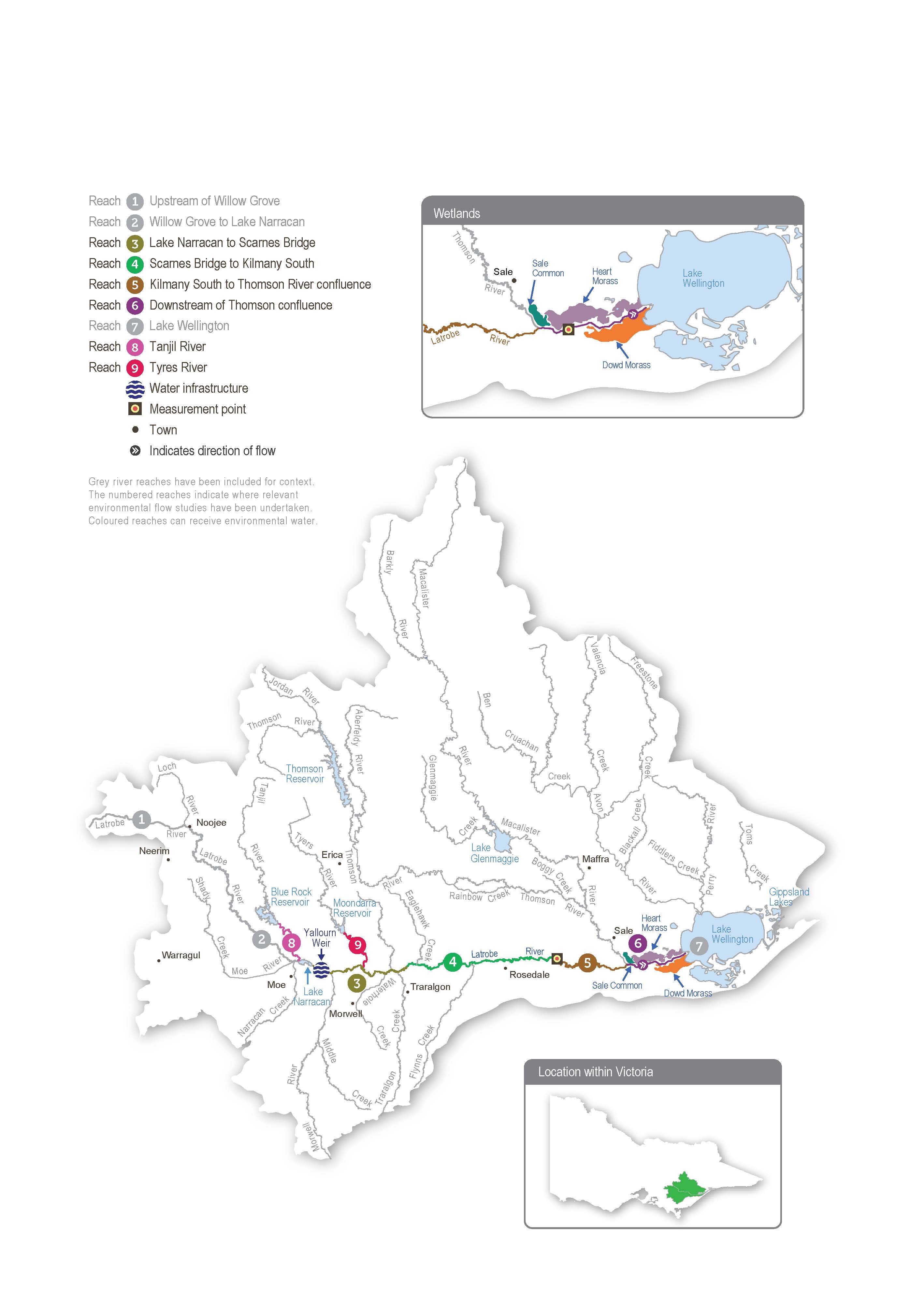
The lower Latrobe wetlands (Dowd Morass, Heart Morass and Sale Common) are an important component of the internationally recognised Gippsland Lakes Ramsar site and provide habitat for waterbirds of state, national and international conservation significance. The wetlands are located on the floodplain of Durt-Yowan (Latrobe River) between its confluence with Carran Carran (Thomson River), and they form part of the Gippsland Lakes system.
River regulation and water extraction from the Latrobe, Thomson and Macalister rivers have reduced the frequency of small and medium-sized floods that naturally wet the lower Latrobe wetlands. The construction of levees and drains and the filling of natural depressions have also altered water movement into and through the wetlands. The drainage and flooding regime in all three wetlands is now managed to some extent with regulators connected to the Latrobe River.
Environmental values
Sale Common is one of only two remaining freshwater wetlands in the Gippsland Lakes system. It provides sheltered feeding, breeding and resting habitat for various waterbird species, including the Australasian bittern.
Dowd Morass is a large, brackish wetland that regularly supports rookeries of colonial nesting waterbirds, including Australian white ibis, straw-necked ibis, little black and little pied cormorants, royal spoonbills and great egrets.
Heart Morass is also a large brackish wetland, with open expanses providing shallow feeding habitat for waterbirds, including black swans, Eurasian coots and various duck species. The lower Latrobe wetlands function as a diverse and complementary environmental system. Colonial nesting waterbirds breed among swamp paperbark trees at Dowd Morass in spring. Migratory shorebirds feed on the mudflats that are exposed as the wetlands draw down and dry over the summer. Waterfowl and fish-eating birds use open-water habitat at the wetlands year-round. The wetlands also support threatened vegetation communities, including swamp scrub, brackish herbland and aquatic herbland.
Page last updated: 01/05/25
