On this page:
Latest information about where, when and why environmental water may be delivered to the Macalister River and the environmental objectives being targeted is available in this year’s seasonal watering plan.
The seasonal watering plan also contains information about how environmental flows could support cultural, social, recreational and economic values in the Macalister River.
Watering data for the Macalister River and the wider Gippsland region is updated quarterly. Visit current watering releases to find out more.
To find out the current environmental water entitlements held by the VEWH in the Macalister River visit our water holdings.
Information about the ownership of water entitlements in the Macalister River can be found under the Entitlements and Compliance section of the Thomson basin page at Victorian Water Accounts.
Waterway manager
West Gippsland Catchment Management Authority
Storage manager
Environmental Water Holder
Victorian Environmental Water Holder
Traditional Owners
Gunaikurnai Land and Waters Aboriginal Corporation holds native title, has a Recognition and Settlement Agreement with the Victorian Government, and is the statutory authority for the management of Aboriginal heritage values and culture, under the Victorian Aboriginal Heritage Act 2006.
System overview
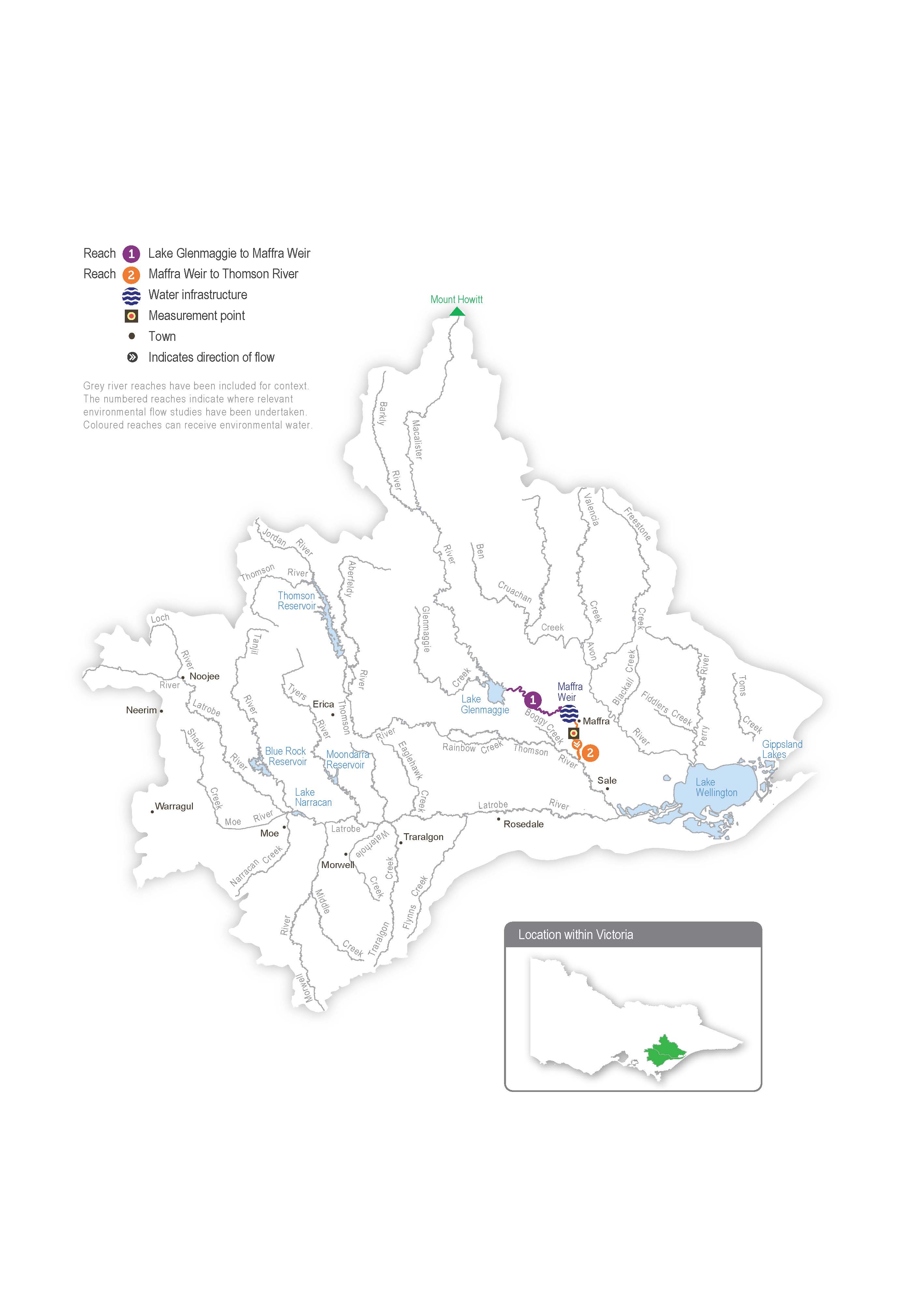
Wirn wirndook Yeerung (Macalister River) flows from Mt Howitt in the Alpine National Park and joins Carran Carran (Thomson River) south of Maffra. The river winds its way to the southeast through mostly forested, confined valleys and narrow floodplains above Lake Glenmaggie. The downstream reaches flow through wide alluvial floodplains that have been cleared for agriculture. The Wellington River and Glenmaggie Creek are the main tributaries of the Macalister River.
Lake Glenmaggie is the major water harvesting storage regulating the Macalister River. Maffra Weir is a small diversion weir located further downstream in Maffra.
Before the construction of Lake Glenmaggie, the Macalister River would regularly receive high and medium flows in winter and spring. Although Lake Glenmaggie regularly spills, a high flow is less frequent than natural because the storage captures much of the water. A notable impact of irrigation and water harvesting is the reversed seasonality of the flow between Lake Glenmaggie and Maffra Weir. The summer flow through this reach is much greater than natural due to the delivery of irrigation water. Winter flow in this reach is lower than natural because a large proportion of the inflows are captured, and there are no irrigation demands over winter. Most irrigation water is diverted at Maffra Weir, and the flow downstream of the weir is lower than natural year-round. The changed hydrology restricts fish migration, limits the growth and recruitment of in-stream and streamside plants and reduces the quality of in-stream habitat.
Water for the environment is stored in Lake Glenmaggie and released to the Macalister River. The river is divided into two reaches for the purposes of managing environmental flows: Lake Glenmaggie to Maffra Weir (reach 1) and Maffra Weir to the Thomson River (reach 2).
Maffra Weir is a major barrier to fish movement along the river, so delivery of water for the environment for migratory fish objectives mainly focuses on reach 2. All other objectives apply to reaches 1 and 2. Construction of a new fish ladder on Maffra Weir to improve fish passage is scheduled to commence in the next few years.
Environmental values
Seven migratory native fish species move between the Macalister River, the estuary and the sea to complete their life cycle. These species include the Australian grayling, short-finned eel, long-finned eel, tupong, Australian bass, short-headed lamprey and common galaxias. Yellow-eye mullet, an estuarine species, has been recorded in the river. Platypus and rakali (water rats) are widely distributed through the Macalister River and its tributaries.
The streamside vegetation corridor along the regulated reaches of the Macalister River is fragmented. Immediately below Lake Glenmaggie, the vegetation is in good condition. It includes remnant river red gums and good-quality stands of shrubs, particularly in areas where revegetation has occurred in combination with stock exclusion. Further downstream, the vegetation is degraded. In recent years, the cover of in-stream vegetation has declined, possibly due to increased water turbidity, erosion and a lack of an appropriate water regime to encourage plant growth. The cover of non-woody plants (such as reeds, sedges and rushes) along the river’s fringes is patchy.
Page last updated: 01/05/25
