On this page:
Latest information about where, when and why environmental water may be delivered to the Thomson River and the environmental objectives being targeted is available in this year’s seasonal watering plan.
The seasonal watering plan also contains information about how environmental flows could support cultural, social, recreational and economic values in the Thomson River.
Watering data for the Thomson River and the wider Gippsland region is updated quarterly. Visit current watering releases to find out more.
To find out the current environmental water entitlements held by the VEWH in the Thomson River visit our water holdings.
Information about the ownership of water entitlements in the Thomson River can be found under the Entitlements and Compliance section of the Thomson basin page at Victorian Water Accounts.
Waterway manager
West Gippsland Catchment Management Authority
Storage manager
Southern Rural Water
Melbourne Water
Environmental Water Holder
Victorian Environmental Water Holder
Traditional Owners
Gunaikurnai Land and Waters Aboriginal Corporation holds native title, has a Recognition and Settlement Agreement with the Victorian Government, and is the statutory authority for the management of Aboriginal heritage values and culture, under the Victorian Aboriginal Heritage Act 2006.
System overview
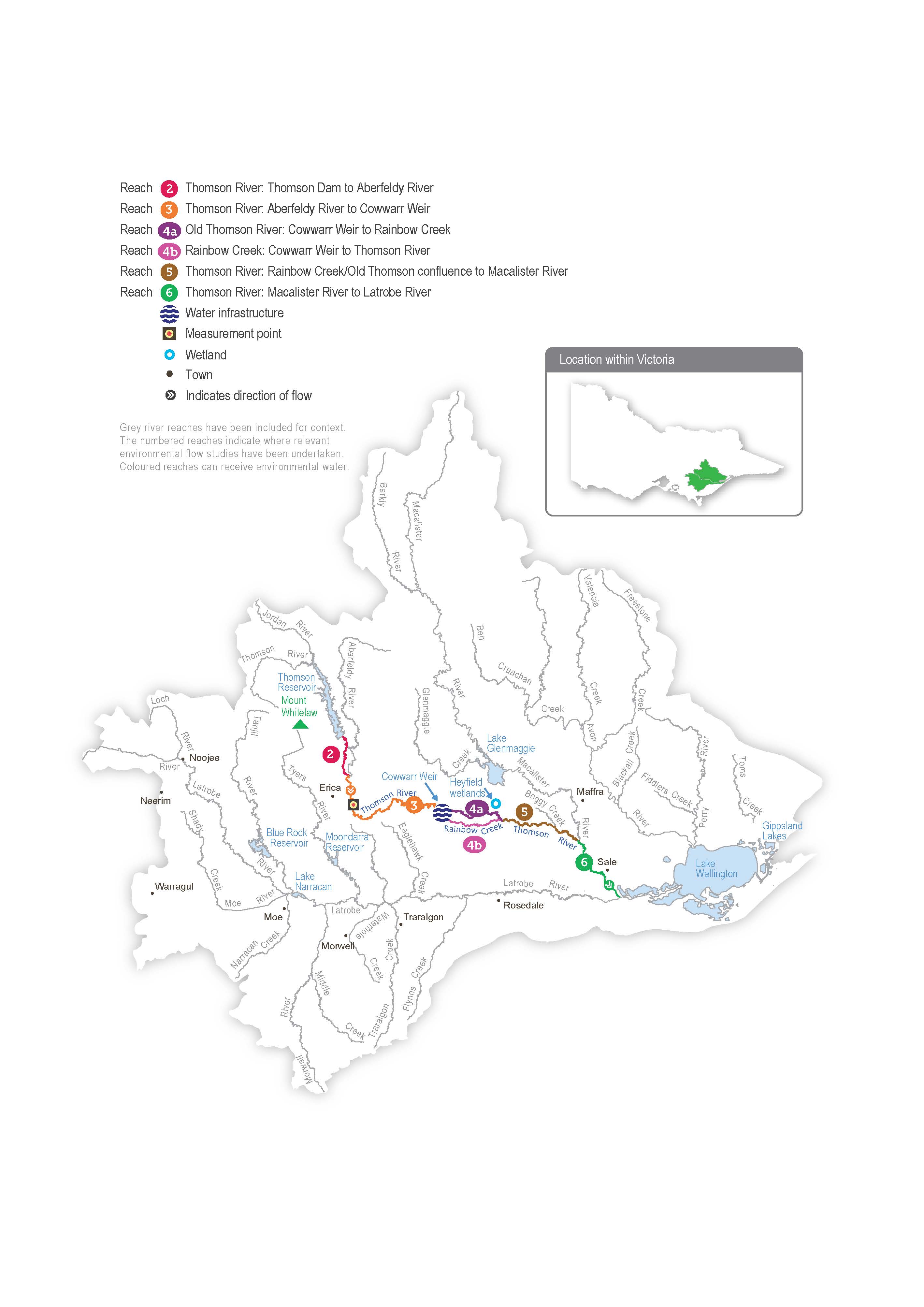
Carran Carran (Thomson River) flows from the slopes of the Baw Baw Plateau to join Durt-Yowan (Latrobe River) south of Sale. The major tributaries of the Thomson River are the Aberfeldy and Jordan rivers in the upper reaches and Wirn wirndook Yeerung (Macalister River) in the lowest reach. Two major structures regulate flow in the Thomson River: Thomson Reservoir — the largest water supply storage for metropolitan Melbourne — and Cowwarr Weir — a regulating structure that supplies irrigation water to parts of the Macalister Irrigation District.
Thomson Reservoir harvests most of the flow from the upper catchment of Thomson River and significantly affects the flow in all downstream reaches. The Aberfeldy River now provides most of the natural flow variation to the Thomson River below Thomson Reservoir and is essential for providing natural freshes and a high flow.
Water for the environment is held in the Thomson Reservoir and released into the river as required. Reach 3 of the Thomson River (from the Aberfeldy River confluence to Cowwarr Weir) is the highest priority for delivery of water for the environment due to its heritage river status, high-value native streamside vegetation, high-quality in-stream habitat and low abundance of exotic fish species.
At Cowwarr Weir, the Thomson River splits into the old Thomson River course (reach 4a) and Rainbow Creek (reach 4b). Passing flows throughout the year are split two-thirds down reach 4a and one-third down reach 4b to avoid impacts to irrigators located on Rainbow Creek. Water for the environment is primarily delivered to the old Thomson River course (reach 4a) to support fish migration, as Cowwarr Weir impedes fish movement through Rainbow Creek.
The Heyfield wetlands is a cluster of pools located between Thomson River and the township of Heyfield. The construction of levees and weirs along Thomson River means that river water rarely enters the wetlands, and while the largest pool receives stormwater from the Heyfield township, smaller ponds rely on rainfall or pumped water for the environment to maintain environmental values. These values include wetland plant communities planted in recent years as part of a comprehensive revegetation program.
Environmental values
The Thomson River supports native species of migratory fish that need to move between the sea and freshwater environments to complete their life cycles, including Australian grayling, tupong, short- and long-finned eel, Australian bass and pouched and short-headed lamprey. A focus for environmental flows management is the Australian grayling, which is a threatened species in Victoria. Australian graylings spawn in response to autumn freshes, and the larvae and juveniles spend time at sea before returning to the freshwater sections of coastal rivers. A flow that supports key migration periods for Australian grayling also provides spawning and recruitment opportunities that benefit the broader native fish assemblage.
The composition and condition of streamside vegetation varies throughout the Thomson River catchment. The vegetation is intact and in near-natural condition above Thomson Reservoir in the Baw Baw National Park. Streamside vegetation between Thomson Reservoir and Cowwarr Weir is mostly in good condition but is affected by exotic weeds, including blackberry and gorse. Below the Cowwarr Weir, the vegetation is degraded due to stock access and widespread weed invasion.
The Heyfield wetlands are one of the few remaining freshwater wetland sites in the Gippsland Plains landscape. They provide habitat for aquatic and terrestrial animals, including threatened migratory birds that prefer shallow, slow-moving water bodies.
Page last updated: 04/12/25
