On this page:
Latest information about where, when and why environmental water may be delivered to the Loddon River system and the environmental objectives being targeted is available in this year’s seasonal watering plan.
The seasonal watering plan also contains information about how environmental flows could support cultural, social, recreational and economic values in the Loddon River system.
Watering data for the Loddon River system and the wider northern region is updated quarterly. Visit current watering releases to find out more.
To find out the current environmental water entitlements held by the VEWH in the Loddon River system visit our water holdings.
Information about the ownership of water entitlements across the Loddon River system can be found under the Entitlements and Compliance section of the Loddon basin page at Victorian Water Accounts. Environmental water in Pyramid Creek is sourced from the Murray basin and can be found under the Entitlements and Compliance section of the Murray basin page at Victorian Water Accounts.
Waterway manager
North Central Catchment Management Authority
Storage manager
Environmental Water Holders
Victorian Environmental Water Holder
Commonwealth Environmental Water Holder
Traditional Owners
Dja Dja Wurrung Clans Aboriginal Corporation has a Recognition and Settlement Agreement with the Victorian Government and is the statutory authority for the management of Aboriginal heritage values and culture, under the Victorian Aboriginal Heritage Act 2006. The Dja Dja Wurrung people are recognised as Traditional Owners in the upper part of the Loddon catchment.
The Barapa Barapa and Wamba Wemba people are Traditional Owners with connections in the lower part of the Loddon catchment.
System overview
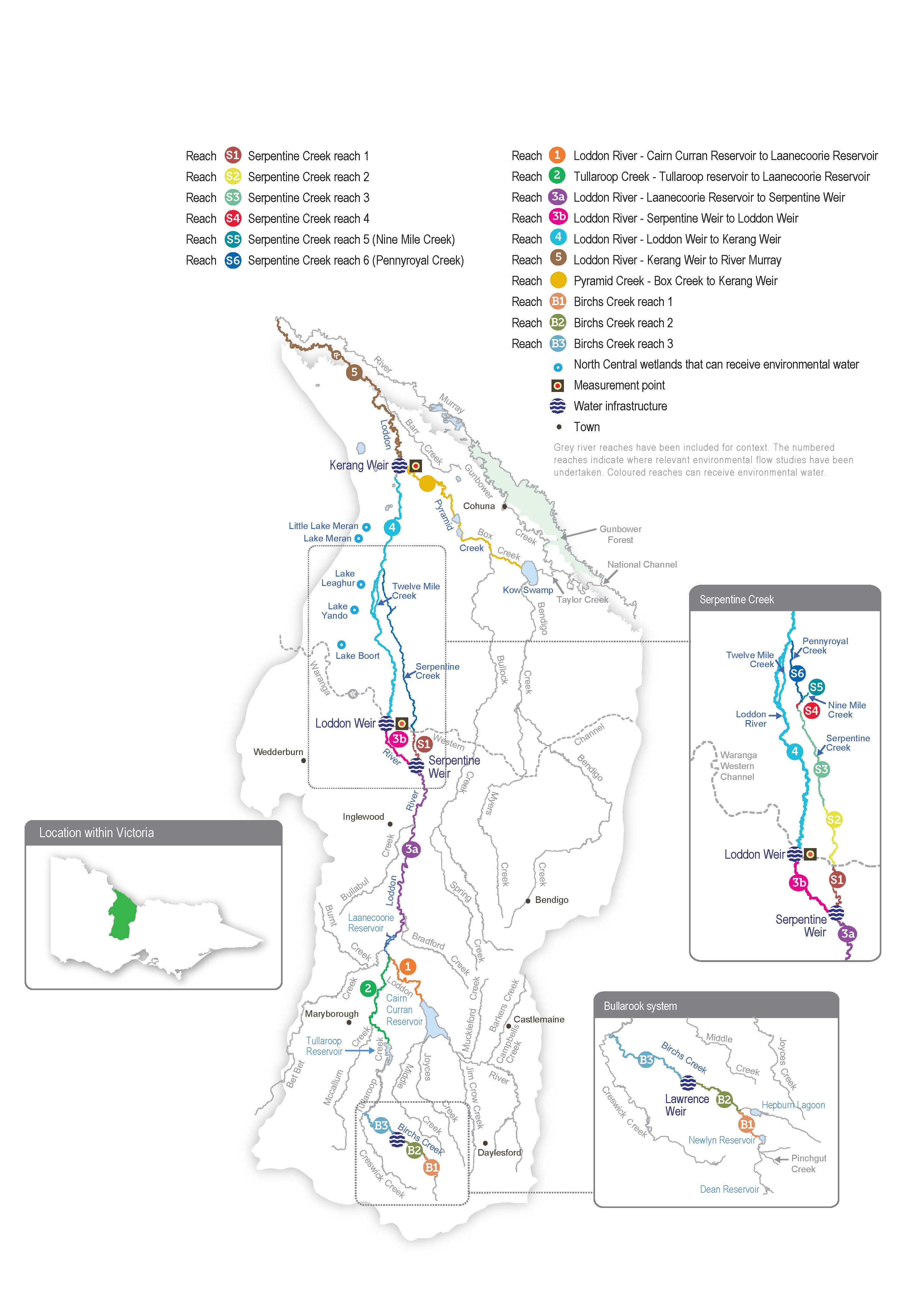
The Loddon River flows from the Great Dividing Range in the south to the Murray River in the north. The middle section of the Loddon River is characterised by many distributary streams and anabranches that carry water away from the river onto the floodplain. Pyramid Creek joins the lower Loddon River at Kerang, at which point the Loddon becomes part of the Murray River floodplain.
The two main storages on the Loddon River are Cairn Curran Reservoir and Tullaroop Reservoir. Laanecoorie Reservoir is a smaller storage used to regulate water released from the larger upstream storages. The operation of the Bridgewater, Serpentine, Loddon and Kerang weirs regulates the Loddon River’s flow downstream of Laanecoorie Reservoir.
Water for the environment can be delivered to the Loddon River from Cairn Curran or Tullaroop reservoirs or from the Goulburn system via the Waranga Western Channel, which intersects with the Loddon River at Loddon Weir. Water is provided to Pyramid Creek through releases from Kow (Ghow) Swamp, which receives water diverted from the Murray River at Torrumbarry Weir. Water is diverted from the Loddon River to the Loddon Valley Irrigation Area to supply agriculture and to Serpentine Creek to support environmental values and supply agriculture.
The highly regulated nature of the Loddon system provides challenges and opportunities for the effective management of water for the environment. The ability to manipulate the timing of releases at multiple locations can help achieve environmental outcomes at discrete locations. However, coordinating environmental and consumptive flows is difficult through the irrigation season, especially when irrigation demand is high or the flow in the river is highly variable. These issues can constrain the timing and delivery of water for the environment or lead to a flow that exceeds the recommended flow rates above Loddon Weir. The structures for managing irrigation water also form barriers in the waterway that restrict native fish movement throughout the river and make it difficult to meet environmental objectives.
Environmental values
The Loddon River system supports platypus, rakali (water rats) and several native fish species (such as Murray cod, golden perch, silver perch, river blackfish and Murray-Darling rainbowfish). Streamside vegetation varies in condition depending on the recent water regime, the extent of clearing and historic and current land management practices. The remaining relatively intact areas support various woodland birds and other native animals. Important plant species across the system include cane grass, tangled lignum, black box and river red gum.
Although fish populations in the Loddon system are affected by the many barriers caused by weirs and reservoirs, many species are still found through the catchment. Native fish are most abundant and diverse in the upper catchment. River blackfish are found in Serpentine Creek, and Murray-Darling rainbowfish are found in the middle and lower sections of the Loddon River.
The highest-priority reach for water for the environment is from Loddon Weir to Kerang Weir. The reach does not carry irrigation water and relies heavily on environmental flows to maintain its environmental condition. Environmental flows to this reach aim to maintain water quality, increase the abundance and diversity of native fish and improve the condition of in-stream and streamside vegetation. Environmental flows are delivered to the upper Loddon River and Serpentine Creek to maintain or increase river blackfish and platypus populations.
Pyramid Creek and the lower Loddon River support large-bodied fish (such as golden perch, Murray cod and silver perch) and are important corridors for fish migration between the Loddon, Murray and Gunbower Creek systems. Engineering works to provide fish passage at the Chute and Kerang Weir on the Loddon River, Box Creek regulator on Pyramid Creek, Taylors Creek Weir on Taylors Creek, and Fish Point Weir and Little Murray Weir on the Little Murray River have been important in reopening these migration routes. The Arthur Rylah Institute has monitored fish movement and populations in Pyramid Creek and the lower Loddon River since 2017. The monitoring indicates that the combined flows in the lower Loddon River and Pyramid Creek stimulate native fish movement through the fishways.
Page last updated: 01/05/25
