On this page:
Latest information about where, when and why environmental water may be delivered to the lower Broken Creek and the environmental objectives being targeted is available in this year’s seasonal watering plan.
The seasonal watering plan also contains information about how environmental flows could support cultural, social, recreational and economic values in the lower Broken Creek.
Watering data for the lower Broken Creek and the wider northern region is updated quarterly. Visit current watering releases to find out more.
To find out the current environmental water entitlements held by the VEWH in the lower Broken Creek visit our water holdings.
Environmental water in the lower Broken Creek is sourced from the Murray and Goulburn basins. Information about the ownership of water entitlements can be found under the Entitlements and Compliance section of the Murray basin page and Goulburn basin page at Victorian Water Accounts.
Waterway manager
Goulburn Broken Catchment Management Authority
Storage manager
Environmental Water Holders
Victorian Environmental Water Holder
Commonwealth Environmental Water Holder
Traditional Owners
Yorta Yorta Nation Aboriginal Corporation (YYNAC) has a Recognition and Settlement Agreement with the Victorian Government and is the statutory authority for the management of Aboriginal heritage values and culture, under the Victorian Aboriginal Heritage Act 2006.
System overview
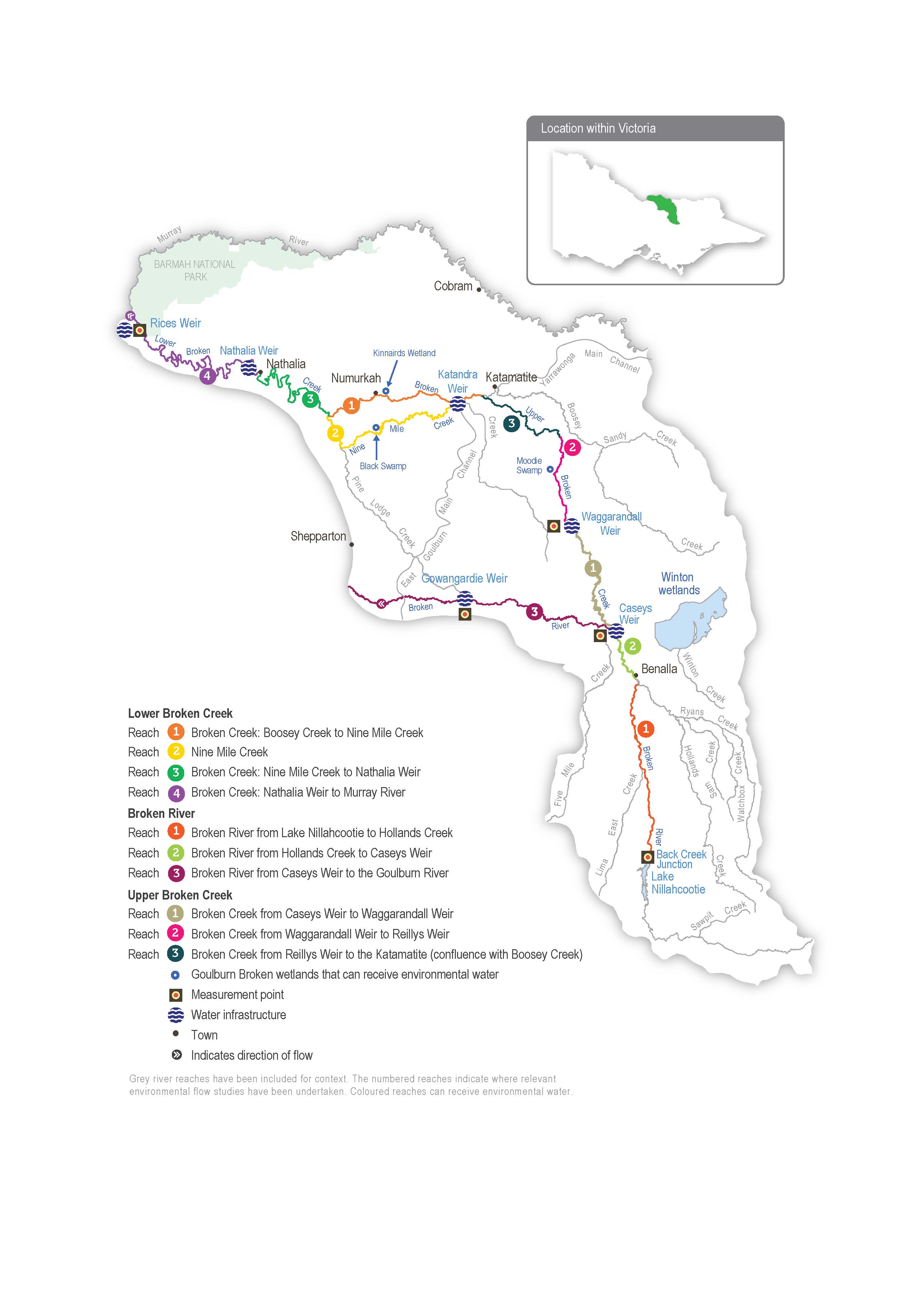
The lower Broken Creek system is within Yorta Yorta Country, and their cultural connection is evident throughout the landscape. The lower Broken Creek system includes the section of Broken Creek that flows from the confluence of Boosey Creek near Katamatite to the Murray River and Nine Mile Creek, which is an anabranch of lower Broken Creek that flows from the East Goulburn Main Channel to below Numurkah.
Lower Broken and Nine Mile creeks have been regulated for over a century. Before regulation, the creeks would have had most of their flow in winter/spring, then contracted to isolated pools or dried out during summer/autumn. The adjacent floodplain would have also flooded regularly. The creeks now have numerous weirs that maintain a relatively constant water level from mid-August until mid-May to support irrigated agriculture and little flow during the non-irrigation season. These modifications have changed how native species use the creek and favour invasive species (such as arrowhead). Previously, native fish would have moved into the creek when it flowed and returned to the Murray River as it dried. Both creeks now provide year-round habitat for native fish, and fish passage structures allow fish to move between weir pools. Water for the environment supports these permanent fish habitats by providing flows to trigger fish movement and support fish passage, encourage the growth of native plants, promote in-stream productivity, control water quality and flush the water fern azolla as necessary.
The irrigation channel network delivers regulated water from the Goulburn and Murray systems to lower Broken Creek. Lower Broken Creek is operated separately from upper Broken Creek and Broken River, and both are supplied from Lake Nillahcootie on the upper Broken River.
Environmental water can be provided to lower Broken Creek from the Goulburn system through the East Goulburn Main Channel and the Murray system through the Yarrawonga Main Channel. Water is released into lower Broken Creek from several irrigation regulators along its length. The main priority for environmental flows in the lower Broken Creek system is a minimum flow throughout the year to maintain suitable habitat for native fish. Particular attention is paid to reaches 1 and 2 during the non-irrigation season when the flow can stop. The next priority is to deliver freshes in winter/spring to trigger fish movement and spawning, maintain water quality and manage azolla accumulations in reaches 3 and 4. Rices Weir is the measurement point for environmental flows in lower Broken Creek.
Operational water releases — inter-valley transfers (IVTs) from the Goulburn to the Murray or Barmah Choke bypass flows delivered to meet downstream demands — partly or wholly meet some environmental flow targets for lower Broken Creek. These operational deliveries mainly occur during peak irrigation demand between spring and autumn. Water for the environment may be used to supplement these operational releases and deliver recommended flow components not met by operational releases.
Environmental values
Lower Broken Creek and Nine Mile Creek support a diverse and abundant native fish community, including the threatened Murray cod, golden perch, silver perch, unspecked hardyhead and Murray-Darling rainbowfish.
Sections of lower Broken and Nine Mile creeks have been reserved as state parks and natural feature reserves. The associated floodplain and wetland habitats support box-dominated grassy woodland communities and numerous species of state and national conservation significance, including river swamp wallaby grass and the Australasian bittern.
Page last updated: 17/03/25
