On this page:
Latest information about where, when and why environmental water may be delivered to Barmah Forest and the environmental objectives being targeted is available in this year’s seasonal watering plan.
The seasonal watering plan also contains information about how environmental flows could support cultural, social, recreational and economic values in Barmah Forest.
Watering data for Barmah Forest and the wider northern region is updated quarterly. Visit current watering releases to find out more.
To find out the current environmental water entitlements held by the VEWH in Barmah Forest visit our water holdings.
Information about the ownership of water entitlements in Barmah Forest can be found under the Entitlements and Compliance section of the Murray basin page at Victorian Water Accounts.
Barmah Forest is part of the Victorian Murray system.
Traditional Owners
Yorta Yorta Nations Aboriginal Corporation (YYNAC) is a Registered Aboriginal Party under the Victorian Aboriginal Heritage Act 2006 and has statutory authority for the management of Aboriginal heritage values and culture, under the Victorian Aboriginal Heritage Act 2006.
System overview
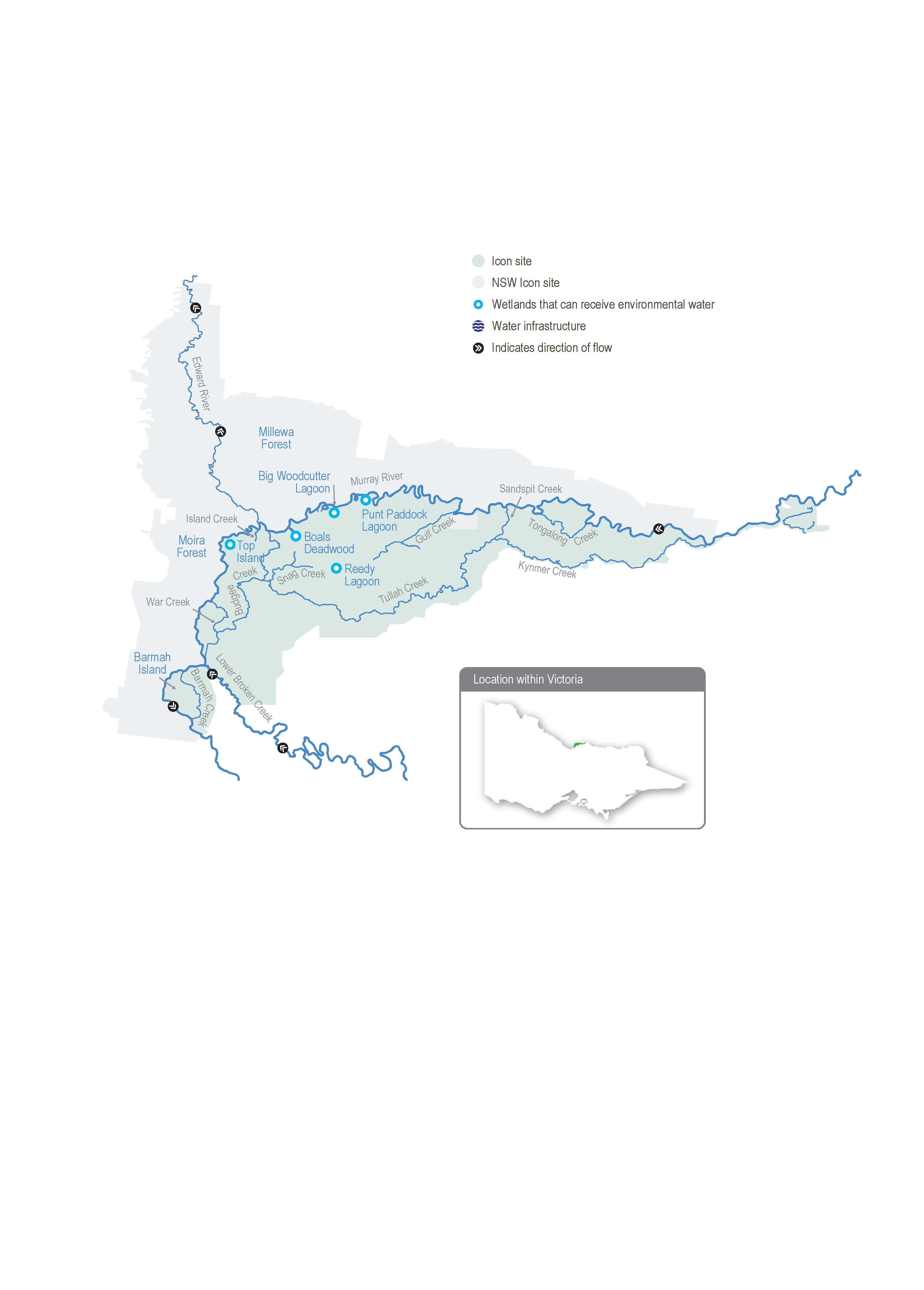
The Barmah Forest is located within Yorta Yorta’s traditional boundaries. The reserve, which includes the Barmah National Park and part of the adjoining Murray Valley Regional Park, is 29,305 ha. It forms the Victorian component of the broader Barmah-Millewa Forest that covers some 66,000 ha across New South Wales and Victoria between Tocumwal, Deniliquin and Echuca. The Barmah-Millewa Forest is listed under the Convention on Wetlands of International Importance (the Ramsar Convention) and the Directory of Important Wetlands in Australia, and it is one of the six Living Murray icon sites. The forest’s Victorian components are the Barmah National Park and part of the River Murray Reserve, which provides legislative protection for river red gum forest and associated wetlands that support significant plant and animal species and culturally significant sites.
Flooding in the Barmah-Millewa Forest depends on the flow in the Murray River. A natural narrowing of the river (commonly called the Barmah Choke) restricts the flow and causes overbank flooding when the flow below Yarrawonga Weir exceeds the channel’s capacity. This restriction influences Yarrawonga Weir’s operation and the magnitude of environmental flows that can be delivered to the forests. The Yorta Yorta People see this narrow part of Dhungulla (Murray River) as a culturally significant creation story, and it provides ecosystem services both from a culturally and environmentally significant viewpoint. The name ‘Barmah Choke’ is culturally inappropriate for the Yorta Yorta, and it is seen as a negative way to view their traditional lands and waters. Yorta Yorta People refer to this as the ‘Pama Narrows’, or more simply ‘The Narrows’.
Before the river was regulated, Barmah-Millewa Forest was regularly flooded with high flows from rainfall and snowmelt in winter and spring. These regular floods shaped a rich, productive floodplain. The construction and operation of Hume Dam and Dartmouth Dam have greatly reduced the size and frequency of natural winter/spring floods in Barmah-Millewa Forest.
Operational deliveries that supply water to users downstream of The Narrows can cause unseasonal, low-level floods, which can damage the forest and erode riverbanks, depending on the timing and volume of the flow. Country for the Yorta Yorta People continues to change, but the changes have been rapid post-settlement due to the installation of infrastructure and river regulation. This has changed Country culturally and environmentally for the Yorta Yorta People.
The delivery of irrigation water during summer/autumn is now managed to minimise the unseasonal flooding of the forest. Regulators along the banks of the Murray River that control the flow between the river and the forest remain closed during summer and autumn to restrict the flow through low-lying flood runners to simulate natural conditions. The delivery of water to Barmah-Millewa Forest is also limited by a flow constraint below Yarrawonga Weir that aims to minimise impacts to adjacent farming operations in NSW. The current constraint limits the regulated flow to a maximum river level of 3.3 m at the Tocumwal gauge (subject to various conditions). Until recently, the 3.3 m limit was met with a flow of about 18,000 ML per day downstream of Yarrawonga Weir, but ongoing sediment accumulation has reduced the river capacity. As a result, the height limit is now met with a flow of about 17,000 ML per day. Regulated flows up to a river level of 3.0 m on the Tocumwal gauge (historically about 15,000 ML per day, now about 14,200 ML per day downstream of Yarrawonga Weir) can be delivered at any time during the year and are not subject to conditions. These constraints mean it is currently not possible to achieve the desired flood depth and duration for floodplain marsh vegetation in both forests at the same time without greater natural flooding. Therefore, environmental watering strategies alternate between the Barmah and Millewa forests each year, aiming to deliver water to low-lying wetlands in each forest at least every second year.
Water management at Barmah-Millewa Forest seeks to build on natural flow and deliver consumptive and operational water to optimise environmental outcomes when possible. As Barmah-Millewa Forest is located towards the upper reaches of the regulated portion of the Murray River, water for the environment that passes through the forest and returns to the river can often be used at sites further downstream as part of multi-site watering events.
Environmental values
The Barmah-Millewa Forest is the nation’s largest river red gum forest and the most intact freshwater floodplain system along the Murray River. The forest supports important floodplain vegetation communities, including the threatened Moira grass plains. It is an important feeding and breeding site for waterbirds, including bitterns, ibis, egrets, spoonbills and night herons. Significant populations of native fish, frogs and turtles also live in the forest’s waterways. Barmah Forest is known to support 74 plant and animal species protected under state and national legislation.
Page last updated: 01/05/25
