On this page:
Latest information about where, when and why environmental water may be delivered to Gunbower Creek and Forest and the environmental objectives being targeted is available in this year’s seasonal watering plan.
The seasonal watering plan also contains information about how environmental flows could support cultural, social, recreational and economic values in Gunbower Creek and Forest.
Watering data for Gunbower Creek and Forest and the wider northern region is updated quarterly. Visit current watering releases to find out more.
To find out the current environmental water entitlements held by the VEWH in Gunbower Creek and Forest visit our water holdings.
Information about the ownership of water entitlements in Gunbower Creek and Forest can be found under the Entitlements and Compliance section of the Murray basin page at Victorian Water Accounts.
Gunbower Creek and Forest are part of the Victorian Murray system.
Traditional Owners
Yorta Yorta Traditional Owners have connections to the upper areas of Gunbower Forest. Yorta Yorta Nation Aboriginal Corporation (YYNAC) is a Registered Aboriginal Party under the Victorian Aboriginal Heritage Act 2006 and has statutory authority for the management of Aboriginal heritage values and culture, under the Victorian Aboriginal Heritage Act 2006.
Barapa Barapa Traditional Owners have connections to the middle and lower areas of Gunbower Forest.
System overview
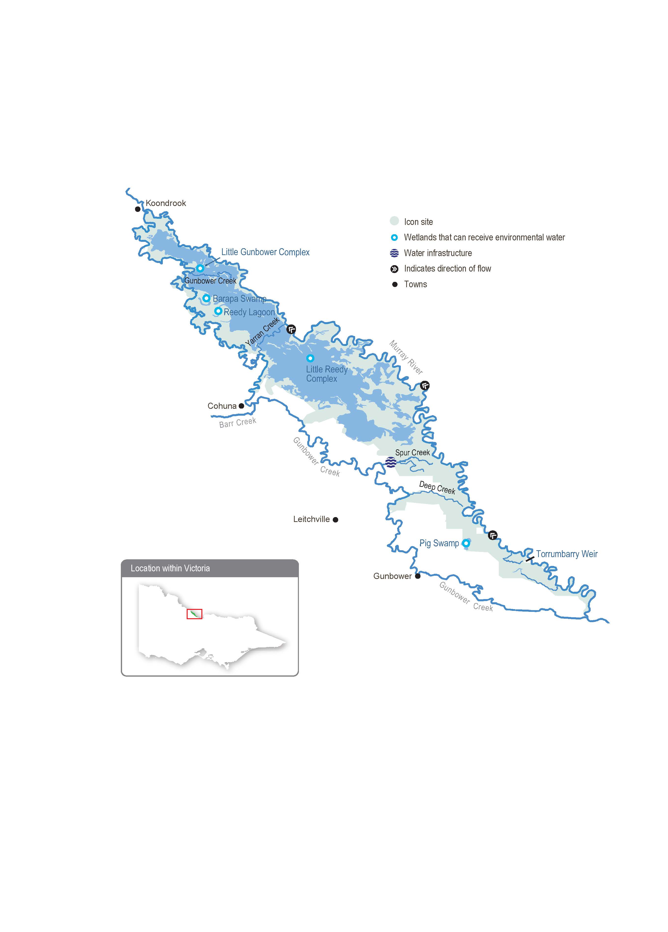
Gunbower Forest is a large, flood-dependent forest situated on the Murray River floodplain in northern Victoria between Torrumbarry and Koondrook.
Gunbower Forest, which covers 19,450 ha, is bounded by the Murray River to the north and Gunbower Creek to the south. It is an internationally significant site under the Ramsar Convention and forms part of the Living Murray Gunbower-Koondrook-Perricoota Forest Icon Site. Regulation of the Murray River and water extraction has reduced the frequency, duration, and magnitude of flood events in Gunbower Forest over the long term. This has affected the extent and condition of floodplain habitats and the health of native plant and animal communities (such as river red gum and black box communities, native fish, birds, platypus, frogs and turtles) that depend on those habitats.
Gunbower Creek is a natural creek that has been modified to supply irrigation water from the Murray River to the Torrumbarry Irrigation Area. There are 12 lagoons, located mainly in the upper reaches of the creek system, that are permanently or seasonally connected to Gunbower Creek. Water for the environment is used in Gunbower Creek to improve habitat for native fish, especially Murray cod.
The Living Murray environmental works program in the middle and lower forest was completed in 2013-14. The works allow up to 4,500 ha of the wetlands and floodplain to be watered with considerably less water than would be required if the watering infrastructure was not in place. The works enable efficient watering through Gunbower Creek and the forest to maintain the wetland and floodplain condition and provide connectivity between the creek, forest floodplain and the Murray River. Frequent connections between the river and floodplain habitats allow animals to move between habitats and support critical ecosystem functions (such as carbon exchange).
Environmental values
Gunbower Forest contains many important environmental values. It includes rare and diverse wetland habitats and large areas of remnant vegetation communities (such as river red gum forest and woodlands). It is home to vulnerable and endangered plants and animals, including river swamp wallaby grass, wavy marshwort, Murray-Darling rainbowfish and eastern great and intermediate egrets. Gunbower Forest also supports internationally recognised migratory waterbird species.
Gunbower Creek provides important habitat for native fish (such as Murray cod, golden perch and freshwater catfish). It is a valuable refuge for native fish and provides a source of fish to recolonise surrounding waterways.
Page last updated: 01/05/25
