On this page:
Latest information about where, when and why environmental water may be delivered to the Glenelg system and the environmental objectives being targeted is available in this year’s seasonal watering plan.
The seasonal watering plan also contains information about how environmental flows could support cultural, social, recreational and economic values in the Glenelg system.
Watering data for the Glenelg system and the wider western region is updated quarterly. Visit current watering releases to find out more.
To find out the current environmental water entitlements held by the VEWH in the Glenelg system visit our water holdings.
Environmental water in the Glenelg, Wimmera and Wimmera-Mallee wetlands systems is sourced from both the Wimmera and Glenelg basins. Information about the ownership of water entitlements in the Glenelg system can be found under the Entitlements and Compliance section of the Wimmera basin page and Glenelg basin page at Victorian Water Accounts.
Waterway manager
Glenelg Hopkins Catchment Management Authority
Storage manager
Grampians Wimmera Mallee Water
Environmental Water Holder
Victorian Environmental Water Holder
Traditional Owners
Gunditj Mirring Traditional Owners Aboriginal Corporation (GMTOAC) holds native title, is a Registered Aboriginal Party under the Victorian Aboriginal Heritage Act 2006 and has statutory authority for the management of Aboriginal heritage values and culture, under the Victorian Aboriginal Heritage Act 2006.
Barengi Gadjin Land Council (BGLC) has a Recognition and Settlement Agreement with the Victorian Government and is a statutory authority for the management of Aboriginal heritage values and culture, under the Victorian Aboriginal Heritage Act 2006. Traditional Owners represented by BGLC hold native title (the Wotjobaluk, Jaadwa, Jadawadjali, Wergaia and Jupagulk peoples).
Burrandies Aboriginal Corporation is based in South Australia and has connections to the western part of the Glenelg River catchment in Victoria.
System overview
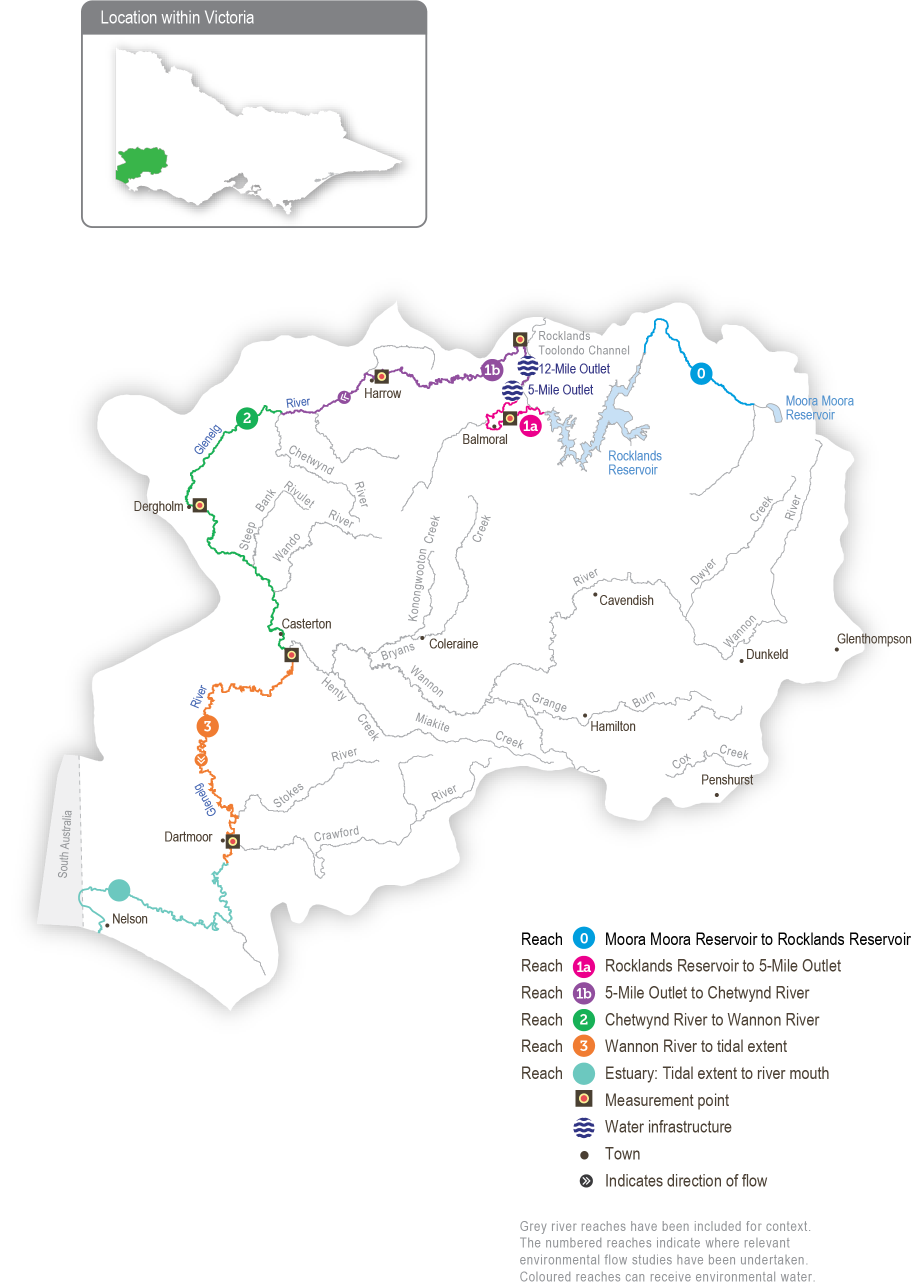
The Glenelg River (Bochara in Dhauwurd Wurrung, Pawur in Bunganditj and Bogara in Wergaia-Jadawadjali languages) rises in Gariwerd (the Grampians National Park) and flows west through Harrow and then south to Casterton and Dartmoor. The Glenelg River estuary flows through South Australia for a short distance before returning to Victoria and flowing into the sea at Nelson. At over 500 km, the Glenelg River is one of the longest rivers in Victoria.
Moora Moora Reservoir and Rocklands Reservoir are Wimmera-Mallee System Headworks water storages in the Glenelg River system that contribute to the supply of water to towns and properties across the Wimmera, Mallee, Glenelg, Loddon and Avoca catchments. Water for the environment is actively managed in the Glenelg River below Rocklands Reservoir. There are passing flow rules for the Glenelg River and upper Wannon River.
The priority reaches of the Glenelg River for deliveries of water for the environment are:
- Moora Moora Reservoir to Rocklands Reservoir (reach 0)
- Rocklands Reservoir to 5-Mile Outlet (reach 1a),
- 5-Mile Outlet to the confluence with the Chetwynd River (reach 1b),
- Chetwynd River to the Wannon River (reach 2), and
- Wannon River to the tidal extent just below the confluence with Crawford River (reach 3).
Water for the environment in the Glenelg system is released from Moora Moora Reservoir for reach 0, Rocklands Reservoir for reach 1a via the reservoir wall outlet and for reaches 1b, 2 and 3 via the 5-Mile and 12-Mile outlets.
The Glenelg River estuary benefits from environmental flows released to upstream reaches, but releases do not currently target the estuary. The Glenelg Hopkins CMA has investigated the importance of water for the environment in the Glenelg River estuary, listed as a heritage river reach and a site of international significance under the Ramsar Convention. Environmental flows provide landscape-scale benefits that support estuarine values.
Environmental values
The Glenelg River starts in Gariwerd (the Grampians National Park) and flows to the sea through the Lower Glenelg National Park. The lower reaches of the Glenelg River are part of a landscape recognised as one of 15 national biodiversity hotspots, and the Glenelg Estuary and Discovery Bay site was listed under the Ramsar Convention as a site of international significance in February 2018.
The Glenelg River supports a range of rare and unique aquatic life, including the endangered Glenelg freshwater mussel, Glenelg spiny crayfish and a newly described species of river blackfish. It is also home to platypus and populations of native fish, including estuary perch, short-finned eel, tupong and three species of pygmy perch, including the threatened variegated pygmy perch and Yarra pygmy perch. Some of these fish species migrate long distances to and from the Glenelg River estuary to complete their life cycles. Sand extraction currently occurs around the Casterton to Dergholm reaches to provide deep pools, habitats and drought refuge areas, important to fish species and the macroinvertebrates that feed them.
Frasers Swamp is another important feature of the upper Glenelg system and is home to a healthy growling grass frog population. The swamp also meets the habitat requirements for the Australasian bittern, and investigations are underway to determine if they use this habitat.
The Glenelg River supports a variety of streamside vegetation communities and species, including the endangered Wimmera bottlebrush. Streamside and floodplain vegetation comprises river red gum woodlands with paperbark, bottlebrush and tea tree understorey.
Page last updated: 04/12/25
