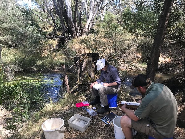
VEFMAP data recording at McKenzie and Mt William Creeks - Arthur Rylah Institute
One question we are often asked at the VEWH is ‘how do you know that water for the environment is being used in the most effective and efficient way?’
Well, much like anything you work hard at – like getting fit or growing tomatoes – the only way to know if you're making progress is to check your results. You set goals, measure and monitor how effective your actions are, then adjust your strategy based on your observations.
It is the same with Victoria's water for the environment program. We use the Victorian Environmental Flows Monitoring Assessment Program (VEFMAP) and the Wetland Monitoring Assessment Program (WetMAP), which are funded by the Department of Environment, Land, Water and Planning, to monitor and help plan our environmental watering efforts.
Across Victoria, every year, there is a carefully coordinated effort to decide which river reaches and wetlands will receive water from the state’s environmental water holding. This planning process culminates in the release of the VEWH’s annual Seasonal Watering Plan. This outlines why, when and where catchment managers will deliver environmental flows, depending on climatic conditions and other factors.
As the year proceeds and the Seasonal Watering Plan is implemented, the impact of water for the environment is measured, monitored and assessed. This occurs through large-scale, multi-site, long-term monitoring programs as well as short, immediate investigations that examine responses to environmental flows at a single wetland or river reach.
The monitoring of environmental watering in Victoria incorporates Commonwealth, Murray Darling Basin, state and regional programs implemented by environmental scientists; some of these programs involve community groups, citizen scientists and Traditional Owners in the collection of data and sharing of information.
The knowledge gained from these assessments provides feedback to water managers about the success of environmental flows and helps them to make more informed and responsive decisions about future watering actions. When you consider all of the monitoring and assessment programs being undertaken across Victoria, what this adds up to is an environmental watering program that improves every year, and which pursues maximum benefit for the environment and communities.
Monitoring programs
Two examples of monitoring programs informing the use of water for the environment across the state are:
- The Victorian Environmental Flows Monitoring Assessment Program (VEFMAP); this program investigates the effect that environmental flows in Victorian rivers have on native fish and aquatic and riverbank vegetation. VEFMAP monitoring is currently conducted at 218 sites along 13 rivers.
- The Wetland Monitoring Assessment Program (WetMAP); this program examines the effect that water for the environment has on native vegetation, waterbirds, fish and frogs in wetlands. Monitoring for WetMAP is conducted at 38 Victorian wetlands.
Both programs are funded by the Victorian Government’s Department of Environment, Land, Water and Planning. On the ground, scientists from the Arthur Rylah Institute for Environmental Research design, plan and carry out the monitoring, in collaboration with university researchers and students as well as a number of experienced contractors. They also coordinate citizen scientist involvement, which includes partnerships with BirdLife Australia and Frogs Victoria. The location of the VEFMAP and WetMAP monitoring sites is shown in Figure 1.
Outcomes
Reports and updates from the Arthur Rylah Institute about responses detected by WetMAP and VEFMAP are used by water managers as evidence of watering impacts. These findings can influence details around delivery of environmental watering such as specific timing or duration and magnitude of flows.
A recent example of this includes a deliberate delay in the delivery of flows to Ned’s Corner Central wetland in the Mallee region, to allow 15 rare or threatened native plant species to complete their lifecycle and set seed ready to re-emerge in the next dry phase.
VEFMAP findings have provided evidence that the Wimmera River region has benefitted from water for the environment. Fish monitoring in autumn 2018 showed that populations of small-bodied native fish have been maintained in all reaches of the Wimmera catchment that received environmental flows.
For the Thomson River system, in areas where there was no livestock grazing and a lot of native plant species, water for the environment increased streamside vegetation cover and recruitment on the river banks.
Rewards from effort
Monitoring programs are the key to ensuring that water for the environment is being used as efficiently and effectively as possible. Its not just a case of add water every year. Far from it!
The Victorian environmental watering program is supported by collaborative efforts to research, plan and deliver water to designated sites in the best way possible. Environmental watering is closely scrutinised; monitored, measured and evaluated through programs including VEFMAP and WetMAP.
Working hard at something as valuable as improving the health of rivers, wetlands and floodplains is always worth the effort.
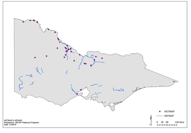
Figure 1. VEFMAP and WetMAP sites