Skip to content


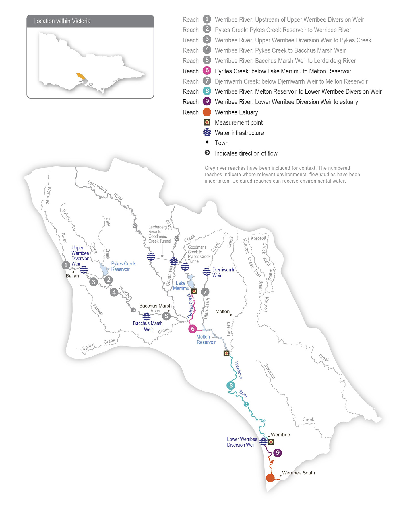
The four reaches in the Werribee system that can receive water for the environment are Pyrites Creek between Lake Merrimu and Melton Reservoir (reach 6), Wirribi Yaluk (Werribee River) between Melton Reservoir and the Werribee Diversion Weir (reach 8), Wirribi Yaluk (Werribee River) between the Werribee Diversion Weir and Werribee Park Tourism Precinct (reach 9) and the Werribee River estuary below the Werribee Park Tourism Precinct.

Environmental flows that target environmental objectives in reach 9 and the estuary are delivered from Melton Reservoir and therefore also benefit reach 8. Water for the environment released from Lake Merrimu is re-harvested in Melton Reservoir, where it can be held and released at an appropriate time to achieve environmental objectives in lower Wirribi Yaluk (Werribee River).

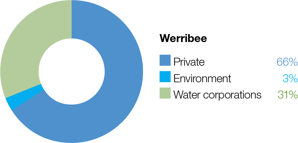
Werribee pie chart

Proportion of water entitlements in the Werribee system held by private users, water corporations and environmental water holders on 30 June 2020

Waterway manager
Traditional Owners
Storage manager
Environmental water holder

System map

Werribee System
Grey river reaches have been included for context. The numbered reaches indicate where relevant environmental flow studies have been undertaken. Coloured reaches can receive environmental water.

Environmental watering objectives in the Werribee River

Fish icon
Protect and increase populations of native freshwater fish species, including galaxiids and Australian grayling.
Protect and increase populations of black bream in the estuary
Plant icon
Maintain the health and increase the cover of in-stream, streamside and estuary plants.
Limit the spread of terrestrial plants, and promote the recruitment of native water-dependent plant species on the banks and benches of waterways
Landscape icon
Maintain channel beds and pool habitats.
Maintain clean substrate surfaces to support biological processes
Maintain native frog populations
Platypus icon
Maintain the platypus population
Maintain and enhance the population of waterbugs, to break down dead organic matter and support the river’s food chain
Water icon
Maintain oxygen and salinity levels in pools

Environmental values

The Werribee system supports a range of native fish, including Australian grayling, river blackfish, flathead gudgeon, short- finned eel, tupong, Australian smelt, several species of galaxiids and a large population of black bream in the estuary. Several species of frogs, a diverse waterbug community and platypus inhabit the upper and lower reaches. The freshwater-saltwater interface of the Wirribi Yaluk (Werribee River) estuary is a regionally significant ecosystem due to the many aquatic plants and animals it supports, and it provides nursery habitat for juvenile freshwater and estuarine fish species (such as black bream).

Recent conditions

The Werribee system experienced wetter-than-average conditions throughout most of 2021-22. The second consecutive year of above-average rainfall meant Pykes Creek Reservoir and Melton Reservoir both spilled through most of winter and spring and into early summer. Allocations against both high- and low-reliability water shares in Melton Reservoir reached 100 percent by early January 2022. Lake Merrimu had above-average inflows, resulting in the highest volume available under the Werribee River environmental entitlement since 2016-17.

Spills from Melton Reservoir between 10 June and 25 December 2021 provided noteworthy flows through reaches 8 and 9 (including bankfull flows in November 2021) and the Werribee River estuary. Despite wet conditions, Pyrites Creek did not have substantial natural inflows in 2021-22 because most flow was harvested in Lake Merrimu, where storage peaked at 82 percent capacity in December 2021, the highest recording since late 2013.

Water-quality-monitoring equipment was installed at Cobbledicks Ford in reach 8 and was upgraded in the Wirribi Yaluk (Werribee River) estuary. The data collected will be used to predict potential algal blooms and inform the delivery of water for the environment to mitigate blooms.

Water for the environment was managed in the Werribee system in accordance with a wet climate scenario in 2021-22. Most planned watering actions were fully achieved through a combination of natural flows, environmental water deliveries and operational flows. In Pyrites Creek, water for the environment was used to deliver four spring freshes and three spring/summer high flows and to maintain low flows to the end of December. In the Werribee River, water for the environment was used to deliver two spring/summer freshes. Passing flows below the Werribee Diversion Weir met the low-flow watering actions during late summer, autumn and winter.

The only planned watering action that was not fully achieved was a summer fresh in the lower Werribee River. Water for the environment was ordered and released from Melton Reservoir to deliver a fresh in late January, but the order was cut short due to operational requirements. Natural freshes before and after the planned event are likely to have met the environmental objectives on this occasion. Melbourne Water, Southern Rural Water and the VEWH are collaborating to reduce the likelihood of similar operational constraints affecting future environmental water orders.

Traditional Owner cultural values and uses

Melbourne Water is working with the Registered Aboriginal Parties within the Werribee system — the Wadawurrung Traditional Owners Aboriginal Corporation, the Wurundjeri Woi Wurrung Cultural Heritage Aboriginal Corporation and the Bunurong Land Council Aboriginal Corporation — to develop overarching partnership agreements to frame relations and obligations between them to strengthen relationships and increase Traditional Owners’ involvement in the planning and delivery of water for the environment. The intent is for Traditional Owners to be active partners in the planning, delivery and monitoring of all works and deliveries of water for the environment associated with Wirribi Yaluk (Werribee River), including the environmental watering program.

There are more opportunities emerging for Melbourne Water and the VEWH to work with Traditional Owner groups to identify and better integrate cultural values and their flow requirements into the environmental watering program on an ongoing basis. All three Registered Aboriginal Parties are involved in the upper Werribee River (Wirribi Yaluk) environmental flow study, which is due to be completed in 2022-23.

The Wadawurrung Traditional Owners Aboriginal Corporation has reviewed the environmental values for the Wirribi Yaluk system and has identified environmental values that also have cultural significance to Wadawurrung Traditional Owners, which the table below shows. However, further work is required to understand how potential watering actions can directly improve these cultural values.

Reach

Extent

Key environmental values with cultural significance to the Wadawurrung

8

Wirribi Yaluk (Werribee River)

Fish iconPlant iconPlatypus icon

9

Wirribi Yaluk (Werribee River) between Wyndham Vale and Bluestone Ford

Fish iconPlatypus icon

EstuaryWerribee River downstream of Bluestone Ford

Fish iconPlant icon

Social, recreational and economic values and uses

In planning the potential watering actions in Table 3.5.1, Melbourne Water considered how environmental flows could support values and uses, including:

  • water-based recreation (such as canoeing, fishing, kayaking and swimming)
  • riverside recreation and amenity from urban cooling (such as camping, walking, cycling and picnicking)
  • community events and tourism (such as Werribee Zo

Scope of environmental watering

Table 1 Potential environmental watering actions, expected watering effects and associated environmental objectives for the Werribee system

Potential environmental watering action

Expected watering effects

Environmental objectives

Pyrites Creek (reach 6)

Winter/spring/summer low flow (two ML/day [or natural] during June to December)

  • Maintain access to food and habitat for waterbugs, native fish and frogs
  • Increase the growth and recruitment of in-stream vegetation

Fish iconFrog iconPlant iconInsect icon

Spring fresh(es) (one to four freshes of 40 ML/ day for two days during September to October)

  • Drown terrestrial plant species that encroach into the waterway
  • Increase the growth and recruitment of streamside and in-stream vegetation
  • Transport carbon to drive aquatic food webs
  • Scour silt, biofilms and algae from substrates to maintain the quality and quantity of food and habitat for waterbugs
  • Improve water quality and the quantity of food and habitat for waterbugs, frogs and native fish
  • Wet depressions adjacent to the stream that frogs can use for breeding

Fish iconFrog iconMountain iconsPlant iconInsect iconWater drop icon

Spring/summer high flow(s) (one to three high flows of 130 ML/ day for two days during September to December)

  • Maintain access to food and habitat for waterbugs, native fish and frogs
  • Increase the growth and recruitment of in-stream vegetation

Fish iconFrog iconPlant iconInsect icon

Lower Werribee River (reaches 8, 9 and the estuary)

Winter/spring low flow (up to 80 ML/day during June to November)

  • Provide flow to allow fish to move upstream past natural and artificial barriers
  • Facilitate the downstream movement of diadromous fish to the estuary
  • Drown terrestrial plant species and support the growth and recruitment of water-dependent streamside vegetation
  • Maintain permanent pools and increase the extent of habitat for waterbugs, fish, platypus and frogs
  • Maintain flow through pool habitats to allow mixing or suppression/ dilution of saline groundwater

Fish iconFrog iconPlatypus iconPlant iconInsect iconWater drop icon

Winter/spring fresh(es) (one to four freshes of 250-350 ML/day for three days during June to October)

  • Support the growth and recruitment of water-dependent streamside vegetation
  • Flush silt and scour biofilms and algae from substrates on the stream bed and maintain pools and channel dimensions
  • Provide movement cues and enough flow for fish to move upstream past natural and artificial barriers
  • Maintain water quality and quantity of food and habitat for waterbugs and platypus
  • Wet depressions adjacent to the stream that frogs can use for breeding

Fish iconFrog iconMountain iconsPlatypus iconPlant iconInsect iconWater drop icon

Summer/autumn low flow (10 ML/day during December to May)

  • Increase the growth and recruitment of in-stream and water-dependent streamside vegetation
  • Maintain access to habitat and improve water quality for native fish, frogs, platypus and waterbugs
  • Maintain flow through pool habitats to allow mixing or suppression/ dilution of saline groundwater intrusion

Fish iconFrog iconMountain iconsPlatypus iconPlant iconInsect iconWater drop icon

Summer/autumn fresh(es) (one to five freshes of 80 ML/day for two days during November to May)

  • Increase the growth and recruitment of water-dependent streamside vegetation
  • Flush silt and scour biofilms and algae from substrates on the stream bed and maintain pools and channel dimensions
  • Maintain access to habitat and improve water quality for native fish, frogs and platypus
  • Provide enough flow for native fish to move downstream past natural or artificial barriers
  • Maintain the quality of water within pools by dispersing azolla and blue- green algae blooms

Fish iconFrog iconMountain iconsPlatypus iconPlant iconInsect iconWater drop icon

Scenario planning

Table 3.5.2 outlines potential environmental watering and expected water use under a range of planning scenarios. Drought planning scenarios are not considered in the four Melbourne Water systems as the potential watering actions are the same as the dry scenario.

The Pyrites Creek catchment downstream of Merrimu Reservoir relies on passing flows, operational releases and environmental flows for virtually all of its flow. Recommended watering actions through reach 6 do not vary significantly between scenarios due to a need to move environmental water to Melton Reservoir to support outcomes in the lower reaches and because the reach is so reliant on releases to maintain any flow. However, the extent to which planned watering actions can be met will vary under each climate scenario. Under a dry scenario, there is unlikely to be enough water for the environment to deliver all required watering actions, so available supply will be prioritised for low flows to maintain enough pool and riffle habitat to allow existing fish, macroinvertebrate and aquatic vegetation communities to persist. Under average and wet conditions, environmental allocations will increase, and a larger proportion of required flows will likely be met by natural inflows. These two factors mean water for the environment can be used under average and wet conditions to deliver additional freshes and high flows to achieve geomorphological objectives, improve the condition of in-stream and streamside vegetation and help grow populations of native fish and frogs.

The lower Wirribi Yaluk (Werribee River) relies on passing flows, operational deliveries and environmental flows to provide low flows and freshes, but unregulated spills from Melton Reservoir, downstream tributary inflows and local run-off, including stormwater from urbanised areas of Werribee, provide larger flows, especially in wet years. Passing flows and operational deliveries for irrigation customers are expected to partially meet low-flow requirements in lower Wirribi Yaluk (Werribee River) under all climate scenarios. Water for the environment will therefore primarily be used to deliver summer/autumn freshes to manage water quality and control potential algal blooms. Winter/spring freshes will be used to support the movement and recruitment of native fish and platypus and to support streamside vegetation. More freshes will be able to be delivered under average and wet scenarios than under a dry scenario.

Under all scenarios, a minimum of 400 ML is planned to be carried over to ensure high-priority flows can be delivered to Pyrites Creek (reach 6) and lower Wirribi Yaluk (Werribee River) in 2023-24. Maintaining sufficient carryover in both Lake Merrimu and Melton Reservoir will be prioritised over the delivery of tier 1b potential watering actions in 2022-23.

Planning scenario table

Table 3.5.2 Potential environmental watering for the Werribee system under a range of planning scenarios

Planning scenario

Dry

Average

Wet

Expected river conditions

  • Regulated flow conditions   below Melton Reservoir year round
  • Minimal passing   flows to reach 6, possible operational water transfers during summer
  • Consumptive   releases out of storage   into reach 8 in   summer/autumn
  • Some   spills from Melton Reservoir in winter/ spring and periods of unregulated   flows in reaches 8 and   9 and the estuary
  • Most low flow in reach 6 met by passing flow
  • Consumptive   releases out of storage into reach 8 in   summer/autumn
  • Regular   large spills from Melton Reservoir in winter/   spring and lengthy periods of unregulated flows in reaches 8 and 9 and the estuary
  • All low   flow in reach   6 provided
  • Consumptive releases out of storage into reach 8 in summer/autumn

Expected availability of water for the environment

  • 2,690 ML
  • 3,250 ML
  • > 3,750   ML

Pyrites Creek (targeting reach 6)

Potential environmental watering – tier 1 (high priorities)

Tier 1a (can be achieved with predicted supply)

  • Winter/spring/summer low flow
  • Spring freshes (three freshes)
  • Spring/summer high flow   (one event)
  • Winter/spring/summer low flow
  • Spring freshes   (three freshes)
  • Spring/summer high flows (two events)

Tier 1b (supply deficit)

 
  • Spring fresh (one fresh)
  • Spring fresh (one fresh)
  • Spring/summer high flow (one event)

Werribee River (targeting reach 9 and estuary)

Potential environmental watering – tier 1 (high priorities)

Tier 1a (can be achieved with predicted supply)

  • Summer/autumn freshes (three freshes)
  • Summer/autumn freshes (five freshes)
  • Winter/spring fresh   (one fresh)
  • Summer/autumn freshes (five freshes)
 

Tier 1b (supply deficit)

 
  • Winter/spring low flow
  • Winter/spring fresh   (one fresh)
  • Summer/autumn low flow
  • Winter/spring low flow
  • Winter/spring freshes (four freshes)
  • Summer/autumn low flow
  • Winter/spring low flow
  • Winter/spring freshes (three freshes)
  • Summer/autumn low flow

Possible volume of water for the environment required to achieve objectives

  • 1,750 ML (tier 1a)
  • 17,950 ML (tier 1b)
  • 2,550 ML (tier 1a)
  • 19,400 ML (tier 1b)
  • 3,100 ML (tier 1a)
  • 18,850 ML (tier 1b)

Priority carryover requirements for 2023-24

  • 400 ML

Engagement

Table 2 shows the partners, stakeholder organisations and individuals with which Melbourne Water engaged when preparing the Werribee system seasonal watering proposal.

Seasonal watering proposals are informed by longer-term regional catchment strategies, regional waterway strategies, environmental flow studies, water management plans and other studies. These incorporate a range of environmental, cultural, social and economic perspectives and longerterm integrated catchment and waterway management objectives. For further details, refer to the Port Phillip and Western Port Regional Catchment Strategy and Melbourne Water's Healthy Waterways Strategy.

Table 2 Partners and stakeholders engaged in developing the Werribee system seasonal watering proposal

Partner and stakeholder engagement
  • Werribee Riverkeeper
  • Department of Environment, Land, Water and Planning | Water and Catchments
  • Southern Rural Water
  • Western Water
  • Environment Protection Authority
  • Parks Victoria (land manager)
  • Port Phillip and Westernport Catchment Management Authority
  • Wyndham City Council
  • Zoos Victoria
  • Werribee Anglers Club
  • Melbourne University – research collaborators
  • Monash University
  • Arthur Rylah Institute (Department of Environment, Land, Water and Planning)
  • Boon Wurrung Foundation
  • Bunurong Land Council Aboriginal Corporation
  • Wurundjeri Woi-Wurrung Cultural Heritage Aboriginal Corporation
  • Wathaurung Aboriginal Corporation

Page last updated: 01/12/22