Skip to content


Lake Glenmaggie is the major water harvesting storage regulating the Macalister River. Maffra Weir is a small diversion weir located further downstream in Maffra.

Before the construction of Lake Glenmaggie, the Macalister River would regularly receive high and medium flows in winter and spring. Although Lake Glenmaggie regularly spills, high flows are less frequent than natural because the storage captures much of the water. A notable impact of irrigation and water harvesting is reversed seasonality of the flow between Lake Glenmaggie and Maffra Weir. Summer flows through this reach are much greater than natural due to the delivery of irrigation water. Winter flows in this reach are lower than natural because a large proportion of the inflows are captured and there are no irrigation demands over winter. Most irrigation water is diverted at Maffra Weir, and flow downstream of the weir is lower than natural year-round. The changed hydrology restricts fish migration, limits the growth and recruitment of in-stream and streamside plants and reduces the quality of in-stream habitat.

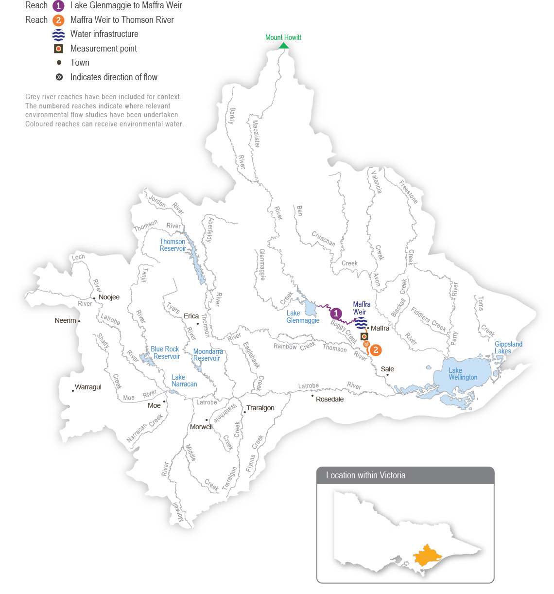
Water for the environment is stored in Lake Glenmaggie and released to the Macalister River. The river is divided into two reaches for the purposes of managing environmental flows: Lake Glenmaggie to Maffra Weir (reach 1) and Maffra Weir to the Thomson River (reach 2).

Maffra Weir is a major barrier to fish movement along the river, so delivery of water for the environment for migratory fish objectives mainly focuses on reach 2. All other objectives apply to both reaches 1 and 2. Construction of a new fish ladder on Maffra Weir to improve fish passage is scheduled to commence in 2024-25, and it is not expected to affect deliveries of water for the environment in 2023-24.

Traditional Owners
Storage manager
Environmental water holder

System map

Macalister System
Grey river reaches have been included for context. The numbered reaches indicate where relevant environmental flow studies have been undertaken. Coloured reaches can receive environmental water.

Environmental watering objectives in the Macalister River

Fish icon
Increase the distribution, recruitment and abundance of all native fish, and increase opportunities for the spawning and recruitment of native migratory fish (such as the Australian grayling)
Maintain the form of the riverbank and bed to provide physical habitat for aquatic animals and plants
Platypus icon
Increase the abundance of platypus and rakali (water rats)
Plant icon
Maintain emergent (non-woody) and fringing (woody) vegetation in the streamside zone

Reinstate submerged aquatic vegetation
Insect icon
Increase the abundance and number of functional groups of waterbugs
Water icon
Improve water quality during periods of reduced or no passing flow from Lake Glenmaggie

Environmental values

Seven migratory native fish species move between the Macalister River, the estuary and the sea to complete their life cycle. These species include the Australian grayling, short-finned eel, long-finned eel, tupong, Australian bass, short-headed lamprey and common galaxias. Yellow-eye mullet, an estuarine species, has been recorded in the river. Platypus and rakali (water rats) are widely distributed through the Macalister River and its tributaries.

The streamside vegetation corridor along the regulated reaches of the Macalister River is fragmented. Immediately below Lake Glenmaggie, the vegetation is in good condition. It includes remnant river red gums and good-quality stands of shrubs, particularly in areas where revegetation has occurred in combination with stock exclusion. Further downstream, the vegetation is degraded. In recent years, the cover of in-stream vegetation has declined, possibly due to increased water turbidity, erosion and a lack of an appropriate water regime to encourage plant growth. The cover of non-woody plants (such as reeds, sedges and rushes) along the river’s fringes is patchy.

Traditional Owner cultural values and uses

Wirn wirndook Yeerung (Macalister River) is a very important river to the Gunaikurnai people. It is a pathway that connects the Snow Country to the heart of Gippsland. It is a pathway to ceremonial grounds and a known special men’s place to Elders. Its traditional name is Wirn wirndook Yeerung, which translates to ‘song of the male fairy wren’.

Yeerung is the men’s totem. This river has many cultural resources and extensive important sites along the whole system.

The Gunaikurnai have had a continued connection to Gunaikurnai Country for over 50,000 years, including with the waterways in the Latrobe system into which Wirn wirndook Yeerung (Macalister River) feeds. For the Gunaikurnai as Traditional Owners, there are immense challenges to heal, protect and manage Country which has been drastically altered since colonisation. “As Gunaikurnai, we see our land (Wurruk), waters (Yarnda), air (Watpootjan) and every living thing as one. All things come from Wurruk, Yarnda and Watpootjan and they are the spiritual life-giving resources, providing us with resources and forming the basis of our cultural practices. We have a cultural responsibility to ensure that all of it is looked after” (Water is Life: Traditional Owner Access to Water Roadmap 2022 - Gunaikurnai Nation Statement). This cultural landscape is dependent on culture and Aboriginal management.

The Gunaikurnai Land and Waters Aboriginal Corporation (GLaWAC) is working with the West Gippsland CMA to determine how to express Gunaikurnai objectives for water in a way that contributes to seasonal watering proposals from the perspective of traditional custodians, with traditional knowledge. GLaWAC has membership on the Macalister Environmental Water Advisory Group (EWAG).

GLaWAC has expressed that more water needs to go down Wirn wirndook Yeerung (Macalister River) between Lake Glenmaggie and Lake Wellington to improve water quality, including to address the threat of salinity and to support plants and animals that have cultural values and uses.

GLaWAC has also questioned the timing of watering events and a desire to provide increased water depth to promote downstream fish migration and spawning, deeper water pools to prevent water-quality degradation, and more variation in water levels to better mimic natural conditions.

Traditionally the landscape – which includes Wirn wirndook Yeerung (Macalister River), and branches and associated floodplains – has been a rich source of food, medicine and resources for the Gunaikurnai people. In the area, there are many sites of cultural significance near the river and around Lake Glenmaggie. The Gunaikurnai have moved through the landscape along the waterways for thousands of years, sourcing food and plants along the way.

From the perspective of the Gunaikurnai, the land and waterways flowing to the Gippsland Lakes are interconnected and cannot be considered separately where decisions can impact downstream areas. The lower Latrobe wetlands and the rivers that feed them, including Wirn wirndook Yeerung (Macalister River), have important cultural significance to the Gunaikurnai.

Watering requirements to support cultural values and uses include:

  • timing the delivery of water for the environment planned in partnership with GLaWAC to support a seasonal flow regime and wet and dry periods that embody healthy Country
  • maintaining freshwater supply to the Durt-Yowan (Latrobe River) estuary, Dowd Morass, Sale Common and Heart Morass, and associated freshwater habitats. The lower Latrobe wetlands are an important resource for the Gunaikurnai
  • providing connectivity between reaches and onto floodplains to support dependent plants and animals with cultural values and uses of significance to the Gunaikurnai
  • maintaining water quality to support the health of native plants and animals with cultural values and uses of significance to the Gunaikurnai.

West Gippsland CMA engaged with the GLaWAC Cultural Water Team about Macalister watering priorities for 2023-24, with engagement planned to continue in the 2023-2024 water year.

Social, recreational and economic values and uses

In planning the potential environmental watering actions in Table 2.4.1, the West Gippsland CMA considered how environmental flows could support values and uses, including:

  • water-based recreation (such as canoeing, kayaking and swimming)
  • riverside recreation and amenity (such as fishing)
  • socioeconomic benefits (such as preventing erosion and potentially losing private and public land).

Scope of environmental watering

The term ‘environmental watering’ refers to the active delivery of water for the environment to support particular environmental objectives by altering the flow in a river or the water level in a wetland. While other terms are also used to describe the delivery of water for the environment, ‘environmental watering’ is deliberately used here and in seasonal watering statements to ensure consistency in the legal instruments that authorise the use of water for the environment in Victoria.

Table 2.4.1 describes the potential environmental watering actions in 2023-24, their expected watering effect (that is, the intended physical or biological effects of the watering action) and the longer-term environmental objectives they support. Each environmental objective relies on one or more potential environmental watering actions and their associated physical or biological effects.

Table 2.4.1 Potential environmental watering actions, expected watering effects and associated environmental objectives for the Macalister system

Potential environmental watering action

Expected watering effects

Environmental objective

Macalister River (targeting reach 2)1

Winter/spring low flow (300 ML/day for at least 120 days during July to November 2023 and June 2024)

  • Provide permanent wetted habitat for waterbugs and maintain water depth over riffles to enable fish passage between local habitats
  • Provide sustained wetting of low-level benches to limit the encroachment of terrestrial vegetation
Fish iconPlant iconInsect icon

Spring fresh (one fresh of 700 ML/day for five days during September to November)

  • Cue the upstream migration of adult fish (e.g. short-headed lamprey) and the recruitment of juveniles (e.g. Australian grayling, tupong, common galaxias, Australian bass and short- and long-finned eels) from marine/ estuarine environments
  • Wet mid-level benches to water woody vegetation, limit the encroachment of terrestrial vegetation and facilitate the dispersal of emergent and fringing vegetation seeds and propagules throughout the reach

Fish iconPlant icon

Spring/summer fresh following spill (one fresh peaking at 1,500-1,800 ML/day for three to 10 days during September to December)

  • Shape the recession of a 1,500 ML/day or 3,000 ML/day spill to:
    • wet mid- and higher-level benches to water emergent and woody vegetation and move organic matter into the channel to transport food resources downstream
    • provide flow with sufficient shear stress to scour biofilms and flush fine sediment from pools and small gaps in the substrate to improve geomorphic habitat and food resources for waterbugs
    • cue the upstream migration of adult fish (e.g. short-headed lamprey) and the recruitment of juveniles (e.g. Australian grayling, tupong, common galaxias, Australian bass and short- and long-finned eels) from marine/ estuarine environments

Fish iconInsect iconMountain iconsPlant icon

Spring/summer low flow (60-90 ML/day during September to January)
  • Maintain the water depth in pools and hydraulic habitat for native fish
  • Maintain permanent wetted habitat in pools and riffles for waterbugs
  • Provide longitudinal connectivity for local movement of platypus and rakali (water rats), as well as protection from predation, access to food sources and maintenance of refuge habitats

Note: At 90 ML per day, expected watering effects are met in reach 1 and 2. At 60 ML per day, expected watering effects are met in reach 2 only.

Fish iconPlatypus iconInsect icon

Trigger-based summer/autumn low flow (40-60 ML/day for five to 13 days during December to May)

Trigger: extended periods of reduced passing flow or no flow being released from Lake Glenmaggie

  • Maintain permanent wetted habitat in pools and riffles for fish and waterbugs to survive
  • Provide shallow, slow-flowing habitat to maintain in-stream vegetation
  • Maintain a minimum depth in pools to allow for turnover of water and to slow degradation of water quality to support aquatic life

Fish iconPlatypus iconInsect icon

Summer/autumn fresh(es) (one to three freshes of 140 ML/day for three to five days during December to March)

  • Increase water depth to allow fish to move throughout the reach
  • Flush pools to maintain water quality for aquatic animals
  • Flush substrates and improve the quality of existing waterbug habitat and food supply
  • Wet low benches to facilitate the dispersal of seeds and propagules from emergent vegetation throughout the reach
  • Provide flow with sufficient shear stress to flush fine sediment from small gaps to improve geomorphic habitat
Fish iconMountain iconsPlant iconInsect icon

Autumn fresh (one fresh of 350 ML/day for five days during April to May)

  • Cue the downstream migration of Australian grayling towards the estuary for spawning
  • Additional benefits for the Thomson River and the Latrobe system are expected when delivered for greater than three days:
  • Fully flush the upper Thomson River estuary when delivered for more than three days and combined with freshes in the Thomson River, and contribute freshwater to the lower reaches of the Latrobe River and wetlands

Fish icon

Autumn/winter low flow (60-90 ML/day during March to August)

  • Maintain pool and riffle habitat for waterbugs and a minimum depth over riffles to allow fish to move throughout the reach
  • Provide connectivity throughout the river for the local movement of platypus and rakali (water rats), and provide protection from predation and access to food
  • Provide a low-velocity flow and clear water to enable the establishment of submerged vegetation

Note: At 90 ML per day, expected watering effects are met in reach 1 and 2. At 60 ML per day, expected watering effects are met in reach 2 only.

Fish iconPlatypus iconPlant iconInsect icon

Autumn/winter fresh (one fresh of 700 ML/day for five days during July to August 2023 or May to June 2024)

  • Cue the downstream migration of Australian bass and tupong towards the estuary for spawning/breeding
  • Increase the wetted area and improve water quality by flushing pools, providing habitat and conditions for waterbugs
  • Wet low and mid-level benches to facilitate the dispersal of emergent and fringing vegetation seeds and propagules throughout the reach

Fish iconPlant iconInsect icon

1 All freshes target reach 2 specifically. Low flows target reaches 1 and 2, but the magnitudes targeted apply to both reaches.

Page last updated: 01/07/22