Skip to content


There are four major dams and multiple diversion weirs in the upper Snowy River catchment that capture and divert water to the Murrumbidgee River and Murray River valleys. The hydrological effects of the Snowy Mountains Scheme are substantial, but they are partly alleviated by the contribution of flows from tributaries (such as the Delegate River in NSW and the Buchan and Brodribb rivers in Victoria).

The construction and operation of the Snowy Mountains Hydro-electric Scheme previously diverted 99 percent of the Snowy River’s mean annual natural flow at Jindabyne. The loss of flow changed the structure and function of the river, reduced the opening of the Snowy River entrance to Bass Strait and resulted in a decline in environmental values.

The Victorian, NSW and Commonwealth governments agreed to recover some of the water and, in 2002, delivered the first environmental flow to the Snowy River below Jindabyne Dam to help restore the damage done by decades of limited flow. The Victorian share of water for the environment available for use in the Snowy system is held in the Victorian Murray, Goulburn and Loddon systems. The NSW share of water for the environment available for use in the Snowy system is held in the NSW Murray and Murrumbidgee systems. Collectively, the water is made available for environmental flows in the Snowy River via a substitution method, whereby water for the environment allocated in Victoria and NSW replaces water earmarked for transfer from the Snowy to Victoria and NSW to support irrigation demands. The NSW Department of Planning and Environment

plans environmental flows in the Snowy River in consultation with the Snowy Advisory Committee. The committee includes representatives of the Aboriginal community, the local community, the Victorian Government, the NSW Government and environmental experts. The committee brings together local knowledge and expert advice to help inform the management and delivery of water for environmental outcomes.

The water year in the Snowy system runs from 1 May to 30 April, and the Snowy Advisory Committee plans the daily flow regime. Water for the environment is delivered daily to the Snowy River below Jindabyne Dam. The annual allocation of water for the environment varies based on water availability, rainfall and inflows. Environmental releases aim to deliver an average of 212,000 ML per year, the equivalent of 21 percent of the average annual natural flows before the construction of the Jindabyne Dam.

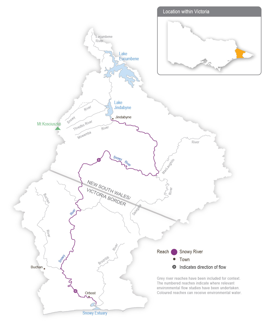
System map

Snowy System SWP
Grey river reaches have been included for context. The numbered reaches indicate where relevant environmental flow studies have been undertaken. Coloured reaches can receive environmental water.

Environmental values

Environmental values in the upper reaches and tributaries of the Snowy River include water-dependant plants and animals, including freshwater native fish (such as river blackfish and Australian grayling), platypus and frogs. The lower reaches support estuary perch and Australian bass that move between saltwater and freshwater systems. The estuary contains estuarine and saltwater species (such as flathead and black bream). The floodplain wetlands of the Snowy River near Marlo provide feeding and breeding areas for wetland and migratory birds.

Traditional Owner cultural values and uses

Traditional Owners with links to the Snowy River system Include the Gunaikurnai, Monero Ngarigo, and Bidhawal peoples.

The river and its associated systems and lands have significant cultural values, including as a functional and spiritual connective pathway. The Snowy River has enduring cultural importance as a place for the gathering of different Nations; ceremonies; access to food, fibre and other resources; stories; spirituality; and songlines.

The Gunaikurnai Land and Waters Aboriginal Corporation holds Registered Aboriginal Party status across a large section of East Gippsland, including the lower Snowy River, associated with the Krauatungalung clan. This landscape was largely a transitionary landscape, with people migrating seasonally from the high country to the coast and back, depending on

availability of different food sources throughout the year. Many trade routes travel through freshwater river systems, such as the Snowy River system.

GLaWAC provided input to the draft Snowy River estuary flows study.

Scope of environmental watering

The total volume available for release to the Snowy River in 2023-24 is 220,500 ML, which for the third year in a row is one of the highest volumes of water for the environment ever available for the Snowy River.

Due to operating rules in the system, the daily flow regime that will be delivered in 2023-24 is pre-planned. The storage manager will make daily releases of varying magnitudes from Lake Jindabyne between May 2023 and April 2024 to mimic the typical flow patterns of a mixed snowmelt/rainfall river system characteristic of the Snowy Mountains. A ‘natural flow scaling’ approach is applied, and the continuous daily releases aim to support ecological processes in the Snowy River below Jindabyne Dam and maintain a healthy river that is much smaller than the natural channel that existed before the river was regulated.

Following wet years in 2021-22 and 2022-23, the availability of water for the environment will again allow for a large number of high-flow releases in 2023-24 to improve ecological conditions and build additional resilience into the system. The flow pattern is similar to previous years and mimics a snowmelt river, with a greater flow during winter and spring. Eight high-flow events exceeding 2,500 ML per day are scheduled between May and November 2023 to move sediment and improve in-stream habitat for native fish, platypus, frogs and waterbugs. The largest release, known as a flushing flow, will occur in either May or October 2023 if Lake Jindabyne is high enough to enable delivery through the required infrastructure. It has a target peak flow rate of at least 5,000 ML per day, which will be held for about eight hours to flush fine sediment and wet high benches and backwaters. Other peak flows will mimic winter rainfall and spring snowmelt events. Moderate-to-high flow rates will be sustained from the end of May to December 2023 to mix water in the estuary to benefit plants and fish (such as Australian bass). Lower flow rates will be maintained from January until the end of the water year in April 2024, but peaks of over 1,000 ML per day will be provided each month where possible.

For further information, visit the NSW Department of Planning and Environment’s Water for the environment website at https://www.environment.nsw.gov.au/topics/water/water-for-the-environment/snowy-and-montane.

Page last updated: 01/07/22