Skip to content


The wetlands throughout the forest continue to provide a constant source of nutritional foods and significant fibres for the Yorta Yorta People. It is also evident that the resources in the landscape were used to manufacture canoes, shields and carrying devices.

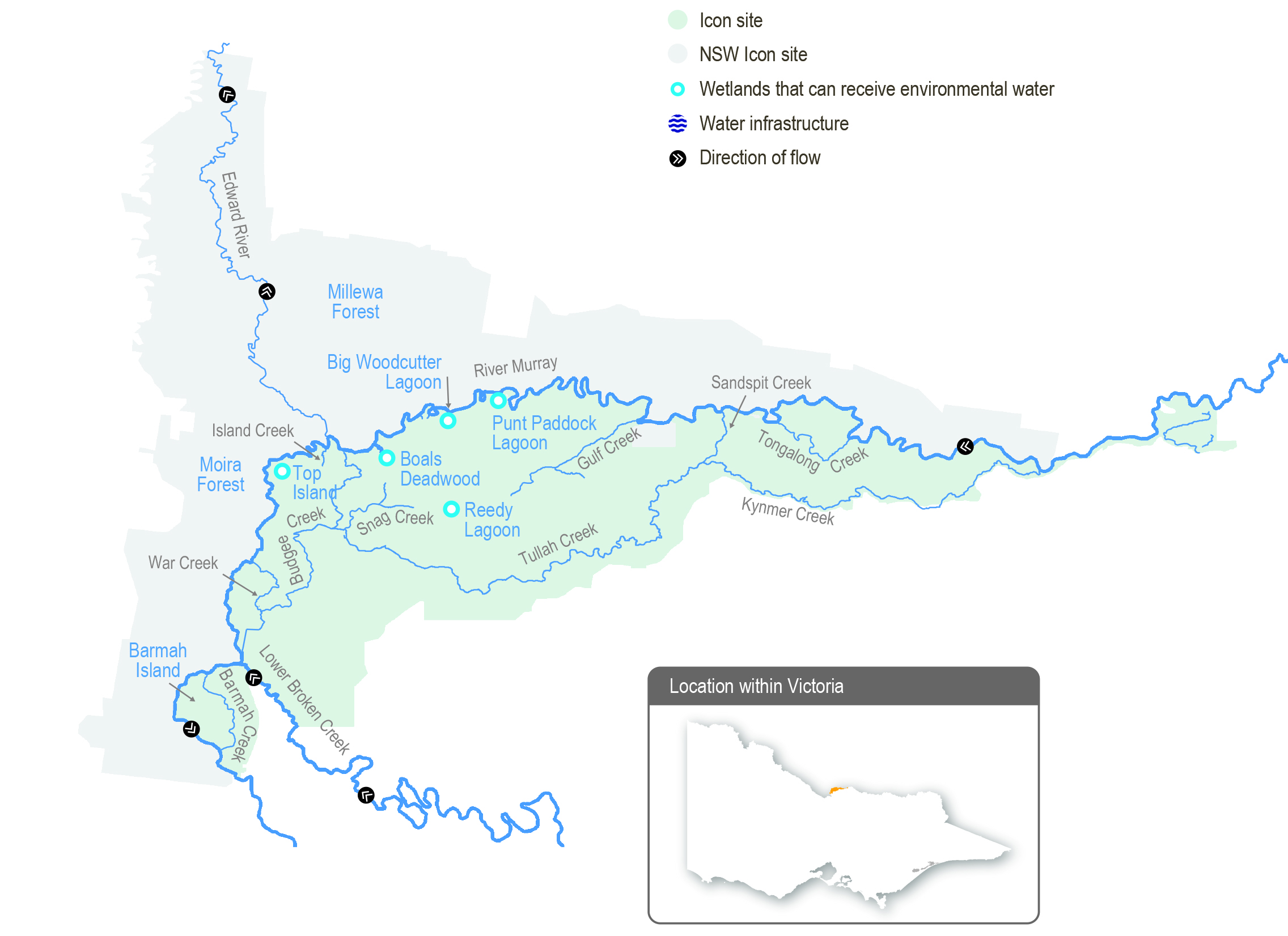
Flooding in the Barmah-Millewa Forest depends on flows in the Murray River. A natural narrowing of the river (commonly referred to as the Barmah Choke) restricts flow and causes overbank flooding when flows below Yarrawonga Weir exceed the channel’s capacity. This restriction influences both the operation of Yarrawonga Weir and the magnitude of environmental flows that can be delivered to the forests. The Yorta Yorta People see this narrow part of Dhungulla as a culturally significant creation story, and it provides ecosystem services both from a culturally and environmentally significant viewpoint. The name ‘Barmah Choke’ is culturally inappropriate for the Yorta Yorta, and it is seen as a negative way to view their traditional lands and waters. Yorta Yorta People may refer to this as the ‘Pama Narrows’, or more simply ‘The Narrows’.

Before the river was regulated, Barmah-Millewa Forest was regularly flooded with high flows from rainfall and snowmelt in winter and spring. These regular floods shaped a rich, productive forest environment. The construction and operation of Hume Dam and Dartmouth Dam have greatly reduced the size and frequency of natural winter/spring floods in Barmah-Millewa Forest.

Also, operational deliveries to supply water to users downstream of The Narrows can cause unseasonal, low-level floods, which can damage the forest and banks of the river depending on the timing and volume of the flows. Country for the Yorta Yorta People continues to change, but the changes have been rapid post-settlement due to infrastructure installation and river regulation. This has changed Country culturally and environmentally for the Yorta Yorta People. Their language word for water is wala, and it includes if an area is wet but may imply to others a ‘flood’, which is viewed as negative water.

The delivery of irrigation water during summer/autumn is now managed to minimise unseasonal flooding of the forest. Regulators along the banks of the Murray River that control flow between the river and the forest remain closed during summer and autumn to restrict flow through low-lying flood runners to simulate natural conditions. The delivery of water to Barmah-Millewa Forest is also limited by a flow constraint below Yarrawonga Weir to minimise impacts to adjacent farming operations in NSW. The current constraint limits regulated flows to a maximum river level of 3.3 m at the Tocumwal gauge (about 18,000 ML per day downstream of Yarrawonga Weir), subject to various conditions. Regulated flow up to a river level of

3.0 m on the Tocumwal gauge (about 15,000 ML per day downstream of Yarrawonga Weir) can be delivered at any time during the year and is not subject to conditions. To overcome this constraint, most environmental flows are shared between Barmah and Millewa forests to deliver water to low-lying wetlands in each forest at least every second year. It is currently not possible to achieve the desired flood depth and duration for floodplain marsh vegetation in both forests at the same time without larger natural flooding.

Water management at Barmah-Millewa Forest seeks to build on natural flow and the delivery of consumptive and operational water en route to optimise environmental outcomes when possible. As Barmah-Millewa Forest is located towards the upper reaches of the regulated portion of the Murray River, water for the environment that passes through the forest and returns to the river can often be used at sites further downstream as part of multi-site watering events.

Traditional Owners

System map

Environmental watering objectives in Barmah Forest

Connected icon
Enable carbon and nutrient cycling between the floodplain and river through connectivity
Maintain or increase habitat for native fish and increase their population
Maintain or increase frog populations
Landscape icon
Protect forest waterways from increased erosion
Maintain turtle populations, including the broad-shelled turtle
Plant icon
Enhance the health of river red gum communities and aquatic vegetation in the wetlands and watercourses and on the floodplain

Promote the growth of floodplain marsh vegetation communities, with a particular focus on increasing the extent of Moira grass
Provide feeding and nesting habitat for the successful recruitment of colonial nesting waterbirds
Reduce the risk of low-oxygen events in summer

Environmental values

The Barmah-Millewa Forest is the largest river red gum forest in Australia and the most intact freshwater floodplain system along the Murray River. The forest supports important floodplain vegetation communities, including the threatened Moira grass plains and is a significant feeding and breeding site for waterbirds, including bitterns, ibis, egrets, spoonbills and night herons. Significant populations of native fish, frogs and turtles also live in the forest’s waterways. Barmah Forest is known to support 74 plant and animal species protected under state and national legislation.

Recent conditions

La Niña events generally result in above-average rainfall years, but back-to-back events in 2020-21 and 2021-22 have resulted in near-average rainfall years for Barmah Forest (as measured at Echuca). Maximum temperatures were also about average for both years.

While local rainfall is important for the forest, upstream Murray River and tributary flows (such as from the Ovens and Kiewa rivers) provide the natural, overbank floods that the forest needs. Rainfall in the Ovens and Kiewa catchments was about average to above average during 2021-22, resulting in some minor, unregulated events during winter and spring. Rainfall in the upper Murray above Hume Dam was above average to very much above average during 2021-22, which resulted in Hume Dam filling and multiple spills — managed high releases — from the storage. These flows combined to deliver four flood peaks of 30,000 to 45,000 ML per day downstream of Yarrawonga Weir during winter and spring 2021, with the largest event in September. While important for the health of the forest, the 2021-22 events were relatively small, inundating about 45 percent of the Barmah Forest floodplain. For context, the wet spring of 2016 resulted in a peak flow of about 180,000 ML per day downstream of Yarrawonga Weir, which inundated an estimated 98 percent of the forest floodplain.

In 2021-22, allocations against high-reliability water shares reached 52 percent in August and 100 percent in October. Low- reliability water shares began receiving allocations in December and reached their full allocations in February. This is the first time Murray seasonal determinations reached maximum availability since the introduction of the current entitlement products in 2007. Spills from Hume Dam resulted in the deduction of most spillable carryover from 2020-21. Section 5.2 has more information about the resource position of water for the environment in the Victorian Murray system during 2021-22.

Water for the environment in Barmah Forest was delivered in line with the average climate scenario in 2021-22. All planned deliveries for the year were fully or partially met, noting autumn-winter (May to June 2022) flows in the Murray River channel are planned but were yet to be delivered at the time of preparing this publication.

Water for the environment was delivered within operational limits to fill in gaps between natural events. Specific actions included maintaining a flow just below 3 m at Tocumwal (about 15,000 ML per day downstream of Yarrawonga Weir) throughout spring and managing recession flows back to below channel capacity in summer. Having a gradual flow recession during December is essential for native fish to move from the floodplain to the river channel without being stranded in forest anabranches. Fish movement was monitored during the recession flow, and the results will be used to inform the magnitude and timing of similar actions in spring 2022-23 and beyond.

Regulators that control flow between the Murray River and Barmah Forest are closed during summer and autumn to prevent high deliveries to downstream irrigation customers from inundating the forest when it would normally be drying. The exception is where water for the environment is diverted into individual wetlands within the forest (such as Boals Deadwood) to improve the success of any waterbird breeding events that may have been triggered by the forest’s inundation in spring. High summer rainfall in the upper Murray catchment triggered some small spills from Hume Dam, and the Barmah Forest regulators were partially opened to reduce the flooding risk to public and private infrastructure. The unseasonal re-wetting of parts of the Barmah floodplain caused some low-oxygen blackwater to develop and flow into the Murray and Edwards rivers. The impact was minor, and no fish deaths were recorded.

A wet climate forecast for winter 2022 on the back of the above-average conditions in 2021-22 resulted in a potential opportunity to commence connecting the forest and the river earlier in winter than in recent years. Increased autumn-winter low flows are planned for June 2022.

Traditional Owner cultural values and uses

“We are the First People of this place. We were here even before the Murray River flowed through Barmah.”

— Uncle Des Morgan, Yorta Yorta Elder, Joint Management Plan for Barmah National Park

Yorta Yorta are joint managers of Barmah National Park with Parks Victoria under a Traditional Owner Land Management Agreement with the State of Victoria. Goulburn Broken CMA met with the Yorta Yorta Nation Aboriginal Corporation during the environmental flows planning process to obtain input and feedback about planned deliveries of water for the environment in Barmah Forest. Yorta Yorta Traditional Owners developed the Yorta Yorta Whole-Of-Country Plan 2021-2030, and they

were involved in developing the Joint Management Plan for Barmah National Park. Both plans have informed planned watering actions. Ongoing interaction on land and water management at Barmah also occurs through the Living Murray Indigenous Partnerships Program.

Yorta Yorta values are more than ‘stones and bones’. They encompass an inherent and living connection to land (woka), water (wala) and caring for Country.

Examples of Yorta Yorta cultural values and uses in Barmah Forest that are supported through water for the environment delivery include:

  • maintaining refuges, which protect turtles, an important totemic species for the Yorta Yorta People
  • watering to support floodplain marsh vegetation, which includes important food, fibre and medicinal plants (such as sneezeweed and weaving sedge)
  • improving the health of river red gums, which has benefits for important Yorta Yorta sites and significant markings (such as a scarred tree) and furthers connections to Country
  • broader restoration to achieving healthy Country.

Social, recreational and economic values and uses

In planning the potential watering actions in Table 5.2.3, Goulburn Broken CMA considered how environmental flows could support values and uses, including:

  • water-based recreation (such as boating, fishing, kayaking and canoeing)
  • riverside recreation and amenity (such as birdwatching, picnicking, photography, camping and the general physical, mental and social benefits of communing with nature)
  • community events and tourism (such as boat tours)
  • socio-economic benefits (such as for apiarists and irrigation diverters).

Scope of environmental watering

Table 5.2.3 describes the potential environmental watering actions in 2022-23, their expected watering effects (that is, the intended physical or biological effects of the watering action) and the longer-term environmental objective(s) they support. Each environmental objective relies on one or more potential environmental watering actions and their associated physical or biological effects.

Table 5.2.3 Potential environmental watering actions, expected watering effects and associated environmental objectives for the Barmah Forest

Potential environmental watering action

Expected watering effects

Environmental objective

Winter/spring forest low flow to various waterways in Barmah Forest (variable flow rates and duration during July to November 2022 and June 2023)

  • Provide a gradual connection of waterways with the Murray River to minimise erosion within those waterways
  • Provide flow in forest waterways to ensure adequate refuge pools persist for native fish and turtles
  • Provide adequate depth and connection between floodplain waterways and the river to facilitate the movement of native fish
  • Remove accumulated organic matter from waterways to cycle carbon to the river system and minimise the risk of hypoxic blackwater by ensuring throughflow

Fish iconMountain iconsTurtle iconJigsaw iconWater drop icon

Winter/spring/summer low flow (8,500- 18,0001 ML/day below Yarrawonga Weir during August to December)

  • Maintain a sufficient water level in the Murray River main channel to prevent Murray cod from abandoning their nests, increase juvenile survival and improve dispersal opportunities

Fish icon

Spring/summer fresh(es) in the Murray River channel (one to three freshes that increase flow by at least 500 ML/ day and maintain it for two to eight days during October to December)

  • Provide variable water levels once water temperatures exceed 22oC to trigger spawning of native fish species, primarily silver perch

Fish icon

Spring/summer/autumn freshes to Gulf and Boals creeks (100 ML/ day for three to five days as required during November to April)

  • Maintain critical refuge pools to provide habitat for native fish and turtles
  • Flush refuge pools to maintain water quality

Fish iconTurtle iconWater drop icon

Spring/summer/autumn low flow to floodplain waterways, including Sandspit, Gulf, Big Woodcutter, Boals and Island creeks and Punt Paddock Lagoon (200 ML/day for 30 to 60 days during November to April)

  • Replenish refuge pools in permanent waterways to maintain water quality, fish and turtle populations
  • Maintain connectivity between the forest and the river
  • Remove accumulated organic matter, cycle carbon to the river system and minimise the risk of hypoxic blackwater

Fish iconTurtle iconWater drop iconJigsaw icon

Fill or top up Boals Deadwood, Harbours Lake, Reedy Lagoon and Top Island wetlands (200-400 ML/day for four and a half months during September to February)

  • Provide a cue to initiate waterbird breeding and maintain a depth of at least 0.5 m beneath reed bed nesting breeding colonies
  • Maintain wetting duration and depth for growth of wetland vegetation

Plant iconHeron icon

Spring wetting of floodplain marshes (variable flow rates of > 9,500-18,0001 ML/day below Yarrawonga Weir for three months during September to December)

  • Wet open plains for sufficient depth and duration to allow the growth of floodplain marsh vegetation
  • Inundate forest wetlands and low-lying floodplain areas to create foraging opportunities for waterbirds and increase available habitat for turtles, frogs and small-bodied native fish

Fish iconFrog iconTurtle iconPlant iconHeron icon

Autumn/winter low flow in the Murray River (1,800-12,000 ML/ day downstream of Yarrawonga during May to June)
  • Increase water depth in the Murray River channel to provide habitat for large-bodied native fish in the Murray River and unregulated anabranches in Barmah-Millewa Forest

Fish icon

1 The maximum flow constraint is a level of 3.3 m at the Tocumwal gauge in the Murray River, estimated at 18,000 ML/day downstream of Yarrawonga Weir. The maximum flow rate actually delivered may vary for these actions.

Scenario planning

Table 5.2.4 outlines potential environmental watering and expected water use under a range of planning scenarios.

The ecological objectives at Barmah-Millewa Forest require sustained flows in the Murray River through winter and spring. Flow control structures are used to direct water from the Murray River channel into the forest. The same structures facilitate the later return of most of that water back to the river, transporting carbon and nutrients for use downstream. Current flow constraints mean water will be biased towards Barmah Forest in 2022-23, aiming to meet depth and duration targets for wetlands. These arrangements alternate between Barmah and Millewa forests each year.

Demands for water for the environment in Barmah Forest vary significantly in response to seasonal conditions. Variable winter/spring low flow and spring/summer freshes are required under all scenarios. The variable winter/spring low flow aims to maintain habitat and movement opportunities for aquatic animals (such as native fish) and is achieved by keeping the regulating structures open and allowing water to move in and out of the forest in response to normal flow variation in the Murray River. The spring/summer freshes are achieved by providing variations in the flow rate in the Murray River below Yarrawonga Weir that trigger the spawning of silver perch.

Under drought and dry conditions, potential environmental flows will primarily aim to maintain water levels and water quality in refuge habitats within the forest to sustain fish and turtle populations. Actions to achieve these objectives require relatively small volumes of water to be directed into the forest, and they are unlikely to return much water to the Murray River for downstream use.

The winter/spring/summer low flow in the Murray River channel will maintain sufficient water levels for successful Murray cod nesting and recruitment under dry to wet climate scenarios. This watering action aims to increase the Murray cod population and improve the recovery of this species. The volume needed to achieve this depends on the contribution of natural flows and the delivery of operational water downstream through The Narrows. This action will provide environmental return flows downstream for use at other sites along the Murray River.

Under the average or wet scenarios, the focus shifts to building resilience in the system by increasing the ecological response to unregulated flooding events. Specific actions under the average or wet scenarios may include extending the duration of unregulated flooding to increase the vigour and resilience of wetland communities (such as Moira grass plains) in floodplain marshes or extending watering in river red gum forests to maintain the health of the trees. These actions may require large volumes of water to be directed into the forest, with water for the environment provided as a directed release from Hume Dam targeting specific flow rates downstream of Yarrawonga Weir and managed using forest regulators. Most of the water used for these actions is eventually returned to the Murray River through the natural shedding action of the floodplain.

A prolonged, low-level, spring watering event in 2022-23 is desirable to help floodplain vegetation flower, set seed and recruit. Some floodplain inundation will occur when the flow downstream of Yarrawonga exceeds about 9,500 ML per day. However, a greater flow will inundate more of the floodplain to a greater depth and therefore deliver a better outcome for floodplain vegetation and also benefit native fish, frogs, turtles and waterbirds. Ideally, the flow will be delivered up to 3.3 m on the Tocumwal gauge (about 18,000 ML per day downstream of Yarrawonga Weir) to inundate larger areas to an appropriate depth in Barmah and Millewa forests.

Regulators may be used to divert water to selected wetlands under various scenarios to support any significant waterbird breeding that is triggered by spring inundation.

Spring wetting of floodplain marshes will provide environmental benefits under all climate scenarios in 2022-23. It is a high priority under dry to wet scenarios but would only be delivered in certain circumstances under the drought scenario.

For example, the size of a multi-site environmental watering action supporting whole-of-River-Murray and/or downstream environmental objectives during winter and spring may increase flow through Barmah Forest. This may be possible in 2022- 23 as water availability in the Murray system is forecast to be high, even under a drought scenario. Another possibility is ‘piggybacking’ operational transfers from Hume Dam with water for the environment. The volume of water for the environment required to achieve the floodplain marsh flow objectives under the drought climate scenario depends on demands for multi-site environmental events or operational transfers, and it is therefore not estimated in Table 5.2.4 below.

Planning scenario table

Table 5.2.4 Potential environmental watering for the Barmah Forest under a range of planning scenarios

Planning scenario

Drought

Dry

Average

Wet

Expected river conditions

  • Unregulated flow periods are unlikely
  • Flow in the Murray River will remain within the channel all year
  • Some small, unregulated flow in late winter/spring
  • Low chance of overbank flow in late winter/spring
  • Likely chance of small-to-medium unregulated flow in winter/spring
  • Likely chance of overbank flow in winter/spring
  • High probability of moderate to large unregulated flow in winter/spring
  • Expected large overbank flow

Potential environmental watering – tier 1 (high priorities)1

  • Winter/spring forest low flow
  • Spring/summer fresh(es) (one to three freshes)
  • Spring/summer/ autumn freshes (to Gulf and Boals creeks)
  • Winter/spring forest low flow
  • Winter/spring/ summer low flow
  • Spring/summer fresh(es) (one to three freshes)
  • Spring/summer/ autumn low flow
  • Fill or top up Boals Deadwood, Harbours Lake, Reedy Lagoon and Top Island wetlands
  • Spring wetting of floodplain marshes
  • Winter/spring forest low flow
  • Winter/spring/ summer low flow
  • Spring/summer fresh(es) (one to three freshes)
  • Spring/summer/ autumn low flow
  • Fill or top up Boals Deadwood, Harbours Lake, Reedy Lagoon and Top Island wetlands
  • Spring wetting of floodplain marshes
  • Autumn/winter low flow (in Murray River)

Potential environmental watering – tier 2 (additional priorities)

  • Spring wetting of floodplain marshes
  • N/A

Possible volume of water for the environment required to achieve objectives2

  • 8,500 ML (tier 1)
  • 550,000 ML (tier 1)
  • 200,000 ML (tier 1)
  • 130,000 ML (tier 1)

1 Tier 1 potential environmental watering at Barmah Forest is not classified as tier 1a or 1b because the water available for use is shared across various systems, and it is not possible to reliably determine the supply specifically available for Barmah Forest.
2 The possible volumes of water for the environment required in Barmah Forest are estimates and highly variable, depending on factors such as seasonal conditions and the contributions of operational and/or unregulated flows. Much of the water for the environment delivered to Barmah Forest is returned to the Murray River — around 80 percent under the dry to wet climate scenarios — and can be reused at downstream sites.

Engagement

Table 2 shows the partners organisations with which Goulburn Broken CMA engaged when preparing the Barmah Forest seasonal watering proposal.

Seasonal watering proposals are informed by longer-term regional catchment strategies, regional waterway strategies, environmental flow studies, water management plans and other studies. These incorporate a range of environmental, cultural, social and economic perspectives and longerterm integrated catchment and waterway management
objectives. For further details, refer to the Goulburn Broken Regional Catchment Strategy and the Goulburn Broken Waterway Strategy.

Table 2 Partners engaged in developing the Barmah Forest seasonal watering proposal

Partner and stakeholder engagement
  • Goulburn Murray Landcare Network
  • Turtles Australia
  • Commonwealth Environmental Water Office
  • Trellys Fishing and Hunting
  • Field and Game
  • Yorta Yorta Nations Aboriginal Corporation
  • Goulburn-Murray Water
  • Parks Victoria
  • Murray Darling Basin Authority (the Living Murray program)

Page last updated: 01/12/22