Skip to content


There are several environmental water holders in the Goulburn system. The Commonwealth Environmental Water Holder (CEWH) holds the largest volume, and the use of Commonwealth Water Holdings is essential for achieving outcomes in the Goulburn River and priority environmental sites further downstream. Water for the environment held on behalf of the Living Murray program may assist in meeting objectives in the Goulburn system en route to icon sites in the Murray system (see subsection 4.4.2). Water held by the VEWH in the Goulburn system is primarily used to meet environmental objectives in the Goulburn River and the Goulburn wetlands, but it can also be used to support ecological objectives at downstream sites along the Murray River and in South Australia.

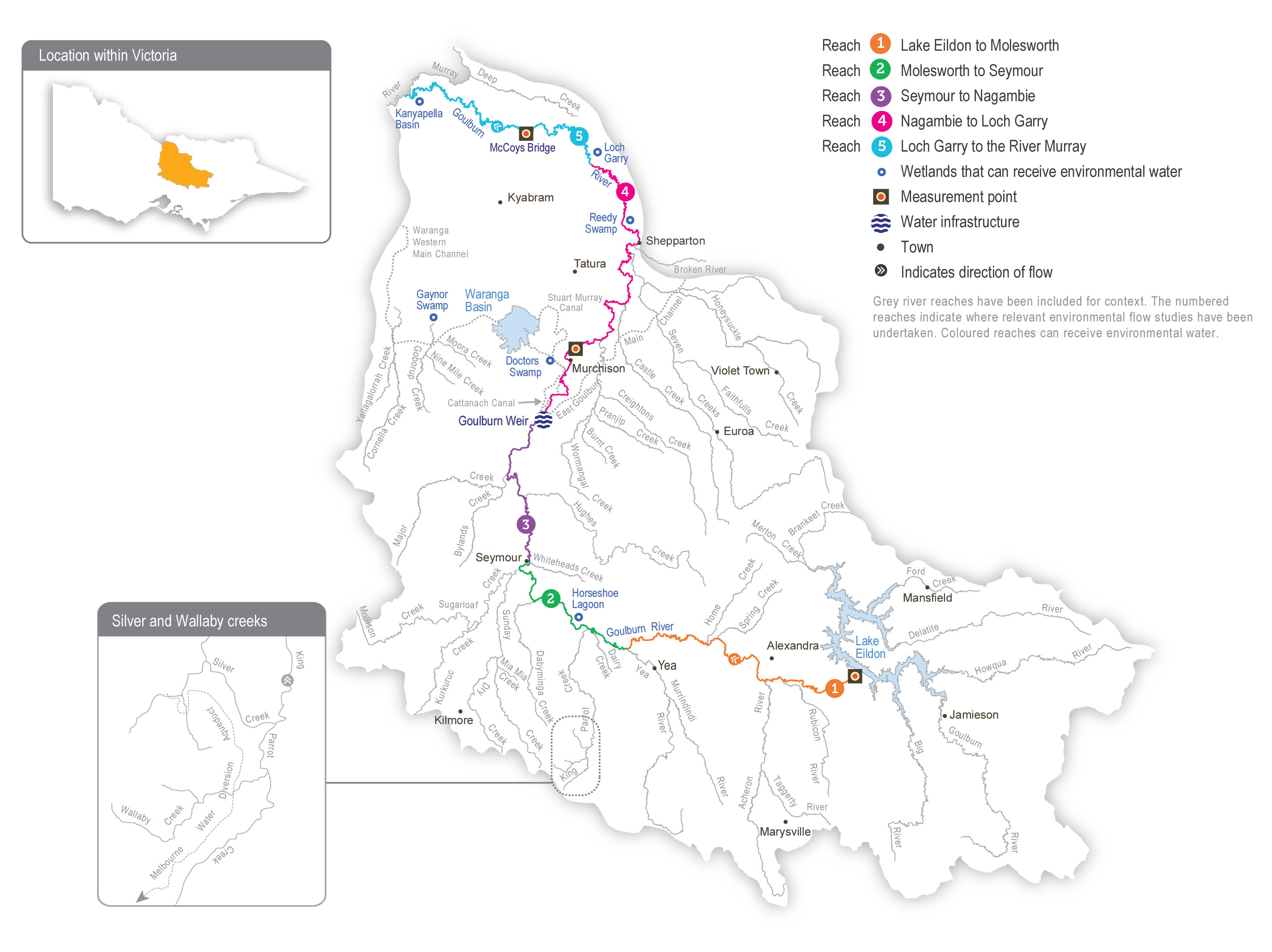
The construction and operation of Lake Eildon and Goulburn Weir have significantly altered the natural flow regime of the Goulburn River. Water harvesting during wet periods, and releases to meet irrigation and other consumptive demands during dry periods, mean that flow below these structures is typically low in winter/spring and high in summer/autumn. This is the reverse of the natural seasonal flow pattern. Land use changes and the construction of small dams and drainage schemes have further modified the Goulburn River’s flow regime. Levees and other structures prevent water from inundating the floodplain and filling many of the natural wetlands and billabongs. Several tributaries, including the Acheron, Yea and Broken rivers, join the Goulburn River downstream of Lake Eildon and can add some flow variation on top of the river’s regulated flow. Large floods that cause the Goulburn River’s storages to fill and spill are also important for the overall flow regime and its associated environmental values.

The priority environmental flow reaches in the Goulburn River are downstream of Goulburn Weir (reaches 4 and 5), which are collectively referred to as the lower Goulburn River. The mid-Goulburn River extends from Lake Eildon to Goulburn Weir (reaches 1 to 3). From early spring to late autumn, large volumes of water are delivered from Lake Eildon to Goulburn Weir to supply the irrigation system. During that period, flow in the mid-Goulburn River is usually well above the recommended environmental flow targets. Deliveries of water for the environment have the most benefit in the mid-Goulburn River (especially in reach 1 immediately downstream of Lake Eildon) outside the irrigation season when the flow is much lower than natural.

Environmental flow targets can sometimes be met by the coordinated delivery of operational water being transferred from Lake Eildon to the Murray River. These inter-valley transfers (IVTs) occur during the irrigation season between spring and autumn and may meet environmental flow objectives without the need to release water for the environment. IVTs in the Goulburn River can significantly exceed the environmental flow recommendations for summer and early autumn and can damage bank vegetation and erode the riverbanks. A new Goulburn to Murray trade rule and operating plan were introduced in 2022-23 to try to prevent further damage to the lower Goulburn River from prolonged high flow over summer and autumn. Wet conditions in 2021-22 and 2022-23 have meant only small volumes of IVTs have been delivered from the Goulburn system. The impacts of the new trade rule and operating plan on environmental assets are yet to be fully assessed.

Traditional Owners
Storage manager
Environmental water holder

System map

Environmental watering objectives in the Goulburn River

Fish icon
Protect and increase populations of native fish
Maintain populations of turtles
Platypus icon
Increase populations of platypus
Landscape icon
Maintain the form of the riverbank and channel and a high diversity of river bed surfaces to support all stream life
Insect icon
Maintain abundant and diverse waterbug communities to support riverine food webs
Water icon
Minimise the risk of low-oxygen blackwater
Connected icon
Provide sufficient rates of carbon and nutrient production and processing to support native fish and waterbug communities
Plant icon
Increase the abundance of aquatic and flood-tolerant plants in the river channel and on the lower banks to provide shelter and food for animals and stabilise the riverbank

Environmental values

The Goulburn River and its tributaries support a range of native fish (including golden perch, silver perch, Murray cod, trout cod, Macquarie perch, freshwater catfish), turtles, platypus and rakali (water rats). Aquatic vegetation, scour holes and woody debris within the channel provide high-quality habitat for adult and juvenile fish. River red gums are a dominant feature of the streamside zone along the length of the Goulburn River. These trees shade the river and provide habitat for many species, including the squirrel glider. Leaves that fall from the river red gums provide carbon that supports riverine food webs, and dead trees that fall into the river provide a surface for biofilms and waterbugs and habitat for fish. Birds (such as egrets, herons and cormorants) use trees along the river to roost and feed, while frogs benefit from shallow vegetated habitats at the edge of the river channel and in adjacent wetlands.

The Goulburn River system is an important conservation area for threatened species. Several wetlands in the Goulburn catchment are formally recognised for their conservation significance. Tributaries of the mid-Goulburn River between Lake Eildon and Goulburn Weir host some of the last remaining Macquarie perch populations in the Murray-Darling Basin, while freshwater catfish occur in lagoons connected to reach 3 of the Goulburn River. Citizen science monitoring programs indicate the mid-Goulburn River supports a strong population of platypus, which are now classified as vulnerable under Victoria’s Fauna and Flora Guarantee Act 1988. Monitoring in recent years shows that environmental flows in the lower Goulburn River trigger golden perch and silver perch to spawn. However, the extent to which these spawning events contribute to populations locally and in the wider southern basin is unknown. Self-sustaining populations of Murray cod have been confirmed, and trout cod are extending their range in the lower Goulburn River.

Traditional Owner cultural values and uses

The Goulburn River system flows through Taungurung and Yorta Yorta Country.

Each year, the Goulburn Broken CMA consults with the Taungurung Land and Waters Council and the Yorta Yorta Nation Aboriginal Corporation about plans for environmental watering in the Goulburn River.

In late 2022 and early 2023, the Goulburn Broken CMA met with the Taungurung water knowledge group Baan Ganalina (Guardians of Water) to discuss recently updated environmental flow recommendations for Waring (Goulburn River reaches 1 to 3) as well as the 2023-24 Goulburn River watering priorities.

Baan Ganalina indicated the flows would help to reinstate a more-natural water regime that better reflects the size, timing and variability of natural inflows to this part of the river, including off-channel areas. It said:

“These flow recommendations will help support Waring (Goulburn River), which is such an important part of Taungurung identity. It’s good to see how GBCMA have used peer-reviewed articles to show the effects on important animals like platypus and shared this knowledge. The river is a work in progress, but together with GBCMA, we will continue to seek ways to heal Country despite the harm it has suffered. Baan Ganalina hopes to see the proposed higher winter flows and looks forward to taking an ongoing role in monitoring their effects.”

The Taungurung Land and Waters Council communicated that the planned reach 1 to 3 baseflows and freshes for 2023-24 would have positive outcomes for Waring (Goulburn River reaches 1 to 3) that align with Taungurung objectives and responsibilities to heal and care for Country. These flows will connect wetlands that support valued species at appropriate times. They will help to protect intangible and tangible cultural heritage and values, including traditional food and medicine plants. The flows will also support ongoing efforts by Taungurung and partner organisations to care for the river and its floodplain, including investigations into rehabilitating degraded significant sites.

In early 2023, the Goulburn Broken CMA met with the Yorta Yorta Nation Aboriginal Corporation to discuss 2023-24 environmental watering priorities in the Goulburn River. The Yorta Yorta Nation Aboriginal Corporation indicated there is alignment between planned watering actions for Kaiela (Goulburn River reaches 4 and 5) and the cultural and ecological values of the Yorta Yorta people. The planned flows will encourage native fish to spawn, alleviate the slumping of culturally important sites (such as middens and scar trees) and revive streamside vegetation, which is important for food, fibre and medicine.

A Yorta Yorta representative contributed to the 2020 Kaiela (Lower Goulburn River) Environmental Flows Study, which has influenced environmental flows in the lower Goulburn River since 2021-22.

Increasing the involvement of Traditional Owners in environmental water management and progressing opportunities towards self-determination in the environmental watering program is a core commitment of the VEWH and its agency partners. This is reinforced by a range of legislation and policy commitments, including the Water Act 1989, the Victorian Aboriginal Affairs Framework, the 2016 Water for Victoria, the Water is Life: Traditional Owner Access to Water Roadmap 2022, and in some cases, agreements under the Traditional Owner Settlement Act 2010.

Where Traditional Owners are more deeply involved in the planning and/or delivery of environmental flows for a particular site, their contribution is acknowledged in Table 5.4.1 with an icon. The use of this icon is not intended to indicate that these activities are meeting all the needs of Traditional Owners, but is incorporated in the spirit of valuing that contribution.

Traditional owners

Watering planned to support water angling activities

In 2022, the Taungurung Land and Waters Council joined the Goulburn and Broken Operational Advisory Group, which shares technical and operational information to support environmental water management and decision-making in the Goulburn River and lower Broken Creek.

Social, recreational and economic values and uses

In planning the potential environmental watering actions in Table 5.4.1, the Goulburn Broken CMA considered how environmental flows could support values and uses such as:

  • water-based recreation (such as boating, canoeing, fishing, gaming, hunting and kayaking)
  • riverside recreation and amenity (for landholders and visitors)
  • community events and tourism (such as paddling and boating businesses)
  • socioeconomic benefits (such as improving water quality for stock and domestic uses, irrigation diverters and water supply for settlements on the Goulburn River).

If the timing or management of planned environmental flows may be modified to align with a community benefit, this is acknowledged in Table 5.4.1 with the following icon.

Fishing icons

Watering planned to support water angling activities

The Goulburn River provides numerous recreational and economic benefits. Environmental flows support native fish populations by providing fish passage and habitat and by encouraging fish migration and spawning, which in turn provide benefits for recreational anglers. Following community feedback, the timing of a targeted environmental flow in November/ December is planned to reduce impacts on river access around peak fishing periods, benefitting anglers and local businesses.

Scope of environmental watering

The term ‘environmental watering’ refers to the active delivery of held environmental water to support particular environmental objectives by altering the flow in a river or the water level in a wetland. While other terms are sometimes used to describe the delivery of environmental water, ‘environmental watering’ is deliberately used here and in seasonal watering statements to ensure consistency in the legal instruments that authorise the use of water for the environment in Victoria.

Table 5.4.1 describes the potential environmental watering actions in 2023-24, their expected watering effect (that is, the intended physical or biological effects of the watering action) and the longer-term environmental objectives they support. Each environmental objective relies on one or more potential environmental watering actions and their associated physical or biological effects.

Table 5.4.1 Potential environmental watering actions, expected watering effects and associated environmental objectives for the Goulburn River

Potential environmental watering action

Expected watering effects

Environmental objectives

Goulburn River reach 1

Year-round low flow (400-2,000 ML/day in reach 1)

Traditional owners
  • Maintain habitat for small-bodied native fish
  • Maintain adequate foraging habitat for platypus and reduce the risk of predation
  • Provide habitat and food for turtles
  • Wet and maintain riffles to provide habitat for biofilms and waterbugs
  • Additional benefits to reach 1 of the Goulburn River when the flow delivered is above 800 ML/day:
    • scour fine sediment from the gravel bed and riffle substrate
    • maintain existing beds of in-channel vegetation
    • provide connection to off-stream wetland habitats, which increase food resources (waterbugs) available for fish and native animals
Fish iconMountain iconsPlatypus iconJigsaw iconWater drop iconInsect icon

Winter fresh (one fresh of more than 8,000 ML/ day for five to 10 days during July to August in reach 1)

Traditional owners

  • Encourage female platypus to select a nesting burrow higher up the bank to reduce the risk of greater flow later in the year flooding the burrow when juveniles are present
  • Scour fine sediment from the gravel bed and riffle substrate
  • Maintain existing beds of in-channel vegetation
  • Connect lower Goulburn River wetlands and anabranches to the river channel
Mountain iconsPlatypus iconPlant icon

Winter/spring fresh(es) (one to three freshes of more than 5,000 ML/day for five to 10 days during May to November in reach 1)

Traditional owners

  • Scour fine sediment from the gravel bed and riffle substrate
  • Maintain existing beds of in-channel vegetation
  • Maximise the period of time off-stream wetland habitats are available for small-bodied native fish and platypus
Fish iconMountain iconsPlatypus iconPlant icon

Spring fresh (one fresh of more than 8,000 ML/ day for five to 10 days during September to November in reach 1)

Traditional owners

  • Maintain off-stream habitat for small-bodied native fish and platypus
  • Scour fine sediment from the gravel bed and riffle substrate
  • Maintain existing beds of in-channel vegetation
  • Connect lower Goulburn River wetlands and anabranches to the river channel
Fish iconMountain iconsPlatypus iconWater drop icon
Goulburn River reaches 4 and 5

Year-round low flow (600-1,000 ML/day in reach 4 and 5)

  • Provide slow, shallow habitat required for the recruitment of larvae/juvenile fish and habitat for adult small-bodied fish
  • Provide deep-water habitat for large-bodied fish
  • Submerge snags and littoral vegetation to provide habitat for fish and waterbugs and a substrate for biofilms to grow
  • Provide habitat and food for turtles
  • Maintain habitat for aquatic vegetation and water the root zone of low-bank vegetation
  • Vary flow within a specified range to encourage plankton production for food, disrupt biofilms and maintain water quality
  • Low, variable flow to enable vegetation to establish to protect against notching and bank erosion
Fish iconMountain iconsPlatypus iconJigsaw iconWater drop iconInsect icon

Winter/autumn fresh (one fresh of more than 7,300 ML/day for four to five days in reaches 4 and 5 during July to August and May to June)

  • Wash organic matter and carbon (e.g. leaf litter) into the channel
  • Provide connectivity to off-channel habitats and through the river for fish dispersal and greater food resources
  • Scour bed sediments to maintain pools and change in-channel complexity to improve habitat
  • Provide cues for platypus to nest higher up the bank
  • Provide sediment and plant propagules from tributary inflows after large rain events to encourage the establishment of new plants
  • Drown terrestrial vegetation on low banks and trigger the recruitment of native, flood-tolerant streamside vegetation
  • Improve waterbug habitat and food availability by scouring fine sediments
Fish iconMountain iconsPlatypus iconJigsaw iconWater drop iconInsect icon

Pass a portion of the flow in the mid-Goulburn to reaches 4 and 5 when flow in reach 3 is above 4,000 ML/day (1,000- 6,000 ML/day in reaches 4 and 5 during May to October

  • Wash organic matter and carbon (e.g. leaf litter) into the channel
  • Transport and deposit seed, sediment and plant propagules on the riverbank
Jigsaw iconWater drop icon

Early spring fresh (one fresh of up to 10,500 ML/ day with more than seven days above 7,300 ML/day during September to October in reaches 4 and 5)

  • Wash organic matter and carbon (e.g. leaf litter) into the channel
  • Provide connectivity to off-channel habitats and through the river for fish dispersal and greater food resources
  • Scour bed sediments to maintain pools and change in-channel complexity for improved habitat
  • Increase soil moisture in banks to improve the condition of existing native vegetation
  • Provide sediment and plant propagules from tributary inflows after large rain events to encourage the establishment of new plants
  • Drown terrestrial vegetation on low banks and trigger the recruitment of native flood-tolerant streamside vegetation
  • Improve waterbug habitat and food availability by scouring fine sediments and biofilms from hard substrates
Fish iconMountain iconsJigsaw iconWater drop iconInsect icon

Late spring fresh (one fresh of more than 6,000 ML/day for two days during October to December in reaches 4 and 5)

Fishing icon

  • Stimulate spawning of golden and silver perch
  • Scour bed sediments to maintain pools and change in-channel complexity for improved habitat
  • Improve waterbug habitat and food availability by scouring fine sediments and biofilms from hard substrates
Fish iconMountain iconsInsect icon

Autumn fresh (one fresh of more than 5,700 ML/ day for two to five days during March to May in reaches 4 and 5)

  • Cue fish to move into and through the system to increase their abundance and dispersal
  • Scour bed sediments to maintain pools, and change in-channel complexity for improved habitat
  • Increase soil moisture in banks to maintain existing vegetation
  • Scour old biofilm from hard substrates to allow new biofilm growth to improve food and habitat for macroinvertebrates
Fish iconMountain iconsWater drop iconInsect icon

Slow the recession of unregulated flow or releases from Goulburn Weir (6,000 ML/day in reaches 4 and 5)

  • Minimise the risk of bank erosion associated with a rapid reduction in the water level
  • Transport and deposit seed, plant propagules and sediment on the riverbank
  • Minimise the risk of low-oxygen blackwater after natural events
Mountain iconsWater drop iconWater drop icon

Page last updated: 01/12/22