Skip to content


The ecology of the Hattah Lakes and the surrounding floodplain is strongly influenced by the flooding regimes of the Murray River. The system fills when there is high flow in the Murray River, and some lakes hold water for several years after floods recede. Regulation of the Murray River has significantly reduced the frequency and duration of small to medium-sized natural floods in the Hattah Lakes system. Over time, this has degraded vegetation communities and reduced the diversity and abundance of animals that use the vegetation and wetlands for habitat and food.

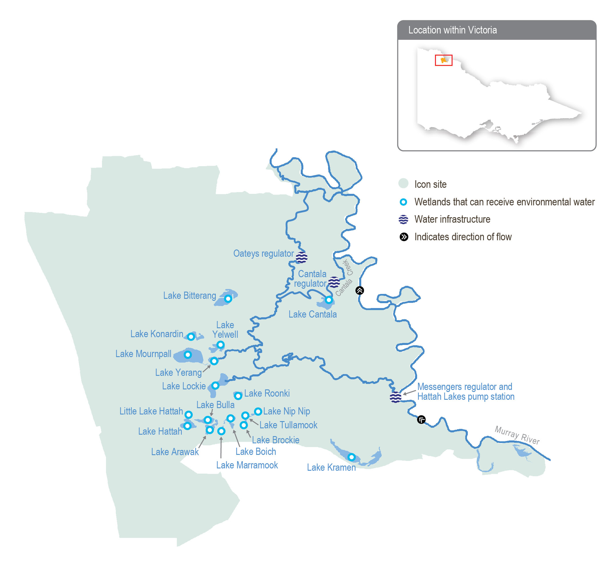
The Hattah Lakes complex can be broadly divided into the southern Hattah Lakes, which contain permanent to semi-permanent wetlands, and the higher-elevation northern Hattah Lakes, which are mostly episodic wetlands.

The Messenger, Oateys and Cantala regulators allow water to flow between the Murray River and the Hattah Lakes. When the flow in the Murray River is about 26,000 ML per day, water begins to flow through Messengers regulator into Chalka Creek and through the Hattah Lakes complex. A permanent pump station can deliver up to 1,000 ML per day to the southern Hattah Lakes through Chalka Creek. The regulators and pump station are used in combination with several small constructed levees to deliver a pattern of flooding to the lakes system that is recommended to improve environmental outcomes. Lake Kramen is in the south-east area of Hattah-Kulkyne National Park and is disconnected from the main Hattah Lakes complex. The Hattah Lakes pump station can deliver up to 145 ML per day to Lake Kramen. New infrastructure proposed under the Victorian Murray Floodplain Restoration Project will allow water to reach additional wetlands and floodplain areas in the northern Hattah Lakes.

Traditional Owners

System map

Environmental watering objectives in the Hattah Lakes

icon-objectives-fish
Maintain populations of small-bodied and large-bodied native fish at the Hattah Lakes
Connected icon
By 2030, improve the function of water-dependent ecosystems by improving productivity linkages between the river and floodplain/wetland habitats
Plant icon
Improve the species richness and abundance of native water-dependent floodplain and wetland aquatic vegetation by 2030

Maintain the extent and improve the condition of river red gum, black box and lignum, compared to 2006 baseline levels by 2030
bird icon
Maintain the regional waterbird population by providing conditions for breeding and fledging at least three times every 10 years

Maintain the regional waterbird population by providing refuge during droughts
Landscape icon
Maintain a variety of freshwater ecosystem types within the Hattah Lakes icon site, including semi-permanent lakes, persistent temporary wetlands, floodplain woodlands, shrublands and episodic wetlands

Environmental values

Hattah Lakes is home to a diverse range of flood-dependent vegetation that changes with the topography of the landscape. Vegetation types range from wetland communities in low-lying areas that require almost annual flooding to lignum and black box communities situated higher on the floodplain that only need flooding once every four to five years (on average).

A combination of natural flooding and the delivery of environmental flows since 2010 has improved tree canopy health and recruitment of black box and river red gum communities throughout the Hattah Lakes. Woodland birds, including the endangered regent parrot, have benefitted from improved tree health.

Hattah Lakes provides important waterbird breeding sites in an arid landscape. A total of 34 species of waterbirds are known to breed at the lakes when conditions are suitable. Another six species of waterbirds breed in the surrounding floodplain.

Wetland drought refuge sites are limited in the region, making the Hattah Lakes critically important for water-dependent flora, waterbirds and terrestrial animals during dry periods.

The Hattah Lakes support large-bodied native fish species (such as golden perch) and small-bodied wetland species (such as carp gudgeon). Fish move between the lakes and the Murray River when the flow is suitable. They also persist in wetlands that retain water in the Hattah Lakes during dry years before re-dispersing during floods.

Traditional Owner cultural values and uses

The Hattah Lakes system is part of a highly sensitive region for Aboriginal cultural values and lies on the border of two documented language groups, the Latji Latji and the Jari Jari. Groups with an interest in Hattah Lakes include Latji Latji, Latji Latji Mumthelang, Tati Tati Kaiejin, Tati Tati Land and Water, Wadi Wadi Land and Water, Murray Valley Aboriginal Corporation, Gilby, Dadi Dadi Weki Weki, Culpra Millee, Nyeri Nyeri and Munatunga Elders.

More than 1,000 Aboriginal archaeological sites at the Hattah Lakes are registered on the Aboriginal Cultural Heritage Register and Information System, with the freshwater lakes and wetlands providing focal points for trade and cultural exchanges among the region’s Traditional Owners. Local Aboriginal communities maintain strong connections to the land and its resources, such as native species used for food and medicine.

In early 2023, the Mallee CMA met with representatives of Latji Latji, Nyeri Nyeri, Dadi Dadi Weki Weki, Wadi Wadi Land and Water, Culpra Millee, Munatunga and Murray Valley Aboriginal Corporation to discuss the history of inundations and delivery to the lakes, as well as environmental water planning for 2023-24 and beyond. Groups invited to discussions included Latji Latji Mumthelang, Tati Tati Kaiejin, Tati Tati Land and Water and Gilby.

Discussions covered the planning of water for the environment and Traditional Owners’ interests and aspirations for the Hattah Lakes region, including:

  • The history of inundation and deliveries, including the environmental outcomes of previous deliveries and recent natural flooding
  • The impacts of recent natural flooding on environmental and cultural values and ways that Traditional Owners can be involved in viewing and assessing these impacts
  • Areas where environmental flows are planned for 2023-24, the quantity of water to be delivered and the planned environmental outcomes from it
  • Projects planned or underway, including the northern Hattah Lakes Victorian Murray Floodplain Restoration Project and ecological monitoring being undertaken across Hattah Lakes through the Living Murray program
  • The spiritual importance of water in the landscape: water connects people to the landscape and culture.

Social, recreational and economic values and uses

In planning the potential environmental watering actions in Table 5.2.12, the Mallee CMA considered how environmental flows could support values and uses, including:

  • Water-based recreation (such as fishing, kayaking and swimming)
  • Riverside recreation and amenity (such as birdwatching, camping, photography and walking)
  • Community events and tourism (educational opportunities, including bushwalking, birdwatching and bug hunting; local school education programs; Melbourne-based schools’ educational excursions; and tours involving kayaking, bike riding and camping)
  • Socioeconomic benefits (such as commercial beekeepers who rest bees away from horticultural orchards in native flowering trees around the lake, multiple ecotourism operators who benefit directly when the lakes contain water, social wellbeing from connecting with nature, and social gatherings)

Scope of environmental watering

The term ‘environmental watering’ refers to the active delivery of held environmental water to support specific environmental objectives by altering the flow in a river or the water level in a wetland. While other terms are sometimes used to describe the delivery of environmental water, ‘environmental watering’ is deliberately used here and in seasonal watering statements to ensure consistency in the legal instruments that authorise the use of water for the environment in Victoria.

Table 5.2.12 describes the potential environmental watering actions in 2023-24, their expected watering effect (that is, the intended physical or biological effects of the watering action) and the longer-term environmental objectives they support. Each environmental objective relies on one or more potential environmental watering actions and their associated physical or biological effects.

Table 5.2.12 Potential environmental watering actions, expected watering effects and associated environmental objectives for the Hattah Lakes

Potential environmental watering action1

Expected watering effects

Environmental objectives

Southern Hattah Lakes (top-ups of selected wetlands to 42.5 m AHD during autumn)

  • Stimulate the growth and improve the condition of river red gums fringing wetlands.
  • Provide feeding habitat for waterbirds
  • Stimulate new growth of aquatic vegetation
  • Inundate dry areas of wetlands to release carbon and nutrients to increase food web productivity
  • Provide spawning and recruitment habitat for small-bodied native fish and nursery habitat for large-bodied native fish (such as golden perch)
  • Inundate a variety of wetland types at different elevations across the Hattah Lakes to increase habitat diversity

Fish iconPlant iconHeron iconConnected iconMountain Stream icon

1In consultation with the VEWH, the Mallee CMA and Parks Victoria, the Hattah Lakes pump station may be operated at any time of year by Goulburn-Murray Water for testing, following pump maintenance and repairs. Water held by the Living Murray Program will be used if testing is required.

Page last updated: 01/12/22