Skip to content


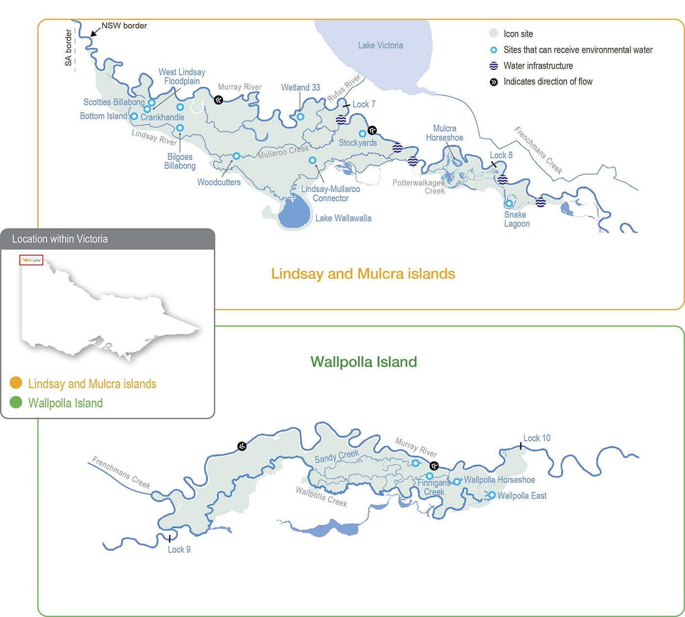
The Lindsay, Mulcra and Wallpolla islands floodplain is characterised by a network of permanent waterways, small creeks and wetlands. The Lindsay River, Potterwalkagee Creek and Wallpolla Creek form the southern boundaries of the site and create large floodplain islands with the Murray River to the north.

In their natural state, these waterways and wetlands would regularly flow and fill in response to high water levels in the Murray River. Large floods still occur, but major storages in the upper reaches of the Murray River system and extraction for consumptive use have reduced the frequency of small- to moderate-sized floods.

Flows in the mid-Murray River system are regulated through a series of weir pools. The weir pools are colloquially called locks, in reference to structures at the weirs that allow vessels to navigate from one weir pool to the next. The weir pools are primarily managed as small water storages to ensure adequate water levels for off-stream diversion via pumps and regulated channels.

Water is diverted from weir pool 9 in the Murray River to Lake Victoria, where it is stored for later use to meet South Australian water demands. The diversion causes water to bypass Murray River weir pools 7 and 8, and at times it can significantly impact flow in those reaches.

In recent years, the water levels in weir pools 7 and 8 have been managed to achieve ecological benefits in the Murray River channel. For example, weir pool levels have been raised during winter and spring and then lowered during summer and autumn to mimic seasonal river flows. The raising and lowering provide greater environmental benefits than a stable weir pool, because it wets and dries off-channel habitats and creates more variable flow patterns in the Murray River and connected floodplain streams. Changes in water levels during appropriate seasons help establish fringing vegetation in shallow margins of the river channel and promote the cycling of nutrients and carbon as conditions fluctuate between wet and dry.

Static weir pool levels and reduced flow in the Murray River have a big effect on flow in the Lindsay River and Potterwalkagee Creek. When natural flow increases and/or when water levels in weir pools 7 and 8 are raised above the full supply level,

the upper Lindsay River starts flowing (Lock 7) and flow to Potterwalkagee Creek increases (Lock 8). When weir pools are lowered, flow to both the Lindsay River and Potterwalkagee Creek ceases. Mullaroo Creek on Lindsay Island is less affected by weir pool levels, and flow is controlled independently through the Mullaroo Creek regulator, which connects the creek and the Murray River. Moderate lowering of the lock 7 weir pool level has little effect on Mullaroo Creek but lowering more than

0.5 m below full supply level makes it difficult to deliver the recommended minimum flow of 600 ML per day that is required to maintain fast-flowing habitat for native fish, especially Murray cod.

Fluctuation of weir pool levels is a major consideration for jurisdictions managing flow in the Murray River and the anabranch waterways of Lindsay, Mulcra and Wallpolla islands. Environmental objectives and associated water regimes for the Murray River sometimes conflict with those for the Lindsay, Mulcra and Wallpolla anabranch systems. Responsible agencies in Victoria and NSW and the Murray-Darling Basin Authority collaboratively plan how to effectively manage weir pools and flows to floodplain habitats.

Traditional Owners

System map

Environmental watering objectives in Lindsay, Wallpolla and Mulcra

Connected icon
By 2030, improve the function of water-dependent ecosystems by improving productivity linkages between river and floodplain habitats
Fish icon
By 2030, increase the abundance of small-bodied native fish and the spread of age classes for long-lived native fish, compared to 2006 baseline levels
Frog icon
Maintain (continuously) or improve (by 2030) populations of flow-dependent fauna
Insect icon
Maintain (continuously) or improve (by 2030) populations of flow-dependent fauna
Plant icon
Maintain (continuously) or improve (by 2030) populations of flow-dependent threatened flora.
Maintain the extent and improve the condition of river red gum, black box and lignum compared to 2006 baseline levels by 2030.
By 2030, improve the species richness and abundance of native wetland and floodplain aquatic vegetation functional groups
bird icon
Maintain communities and species diversity of colonial nesting waterbirds, waterfowl, waders and animals that feed on fish.
By 2030, increase populations of colonial nesting waterbirds at Lake Wallawalla and non-colonial waterbirds at Mulcra Horseshoe and Wallpolla Horseshoe

Environmental values

The Lindsay, Mulcra and Wallpolla islands represent three separate anabranch systems that contain various streams, billabongs, large wetlands and swamps. When flooded, waterways and wetlands within these systems provide habitat for native fish, frogs, turtles, waterbirds and water-dependent plants. Terrestrial animals (such as woodland birds) also benefit from improved productivity and food resources when anabranch systems are inundated. Large floodplain wetlands (such as Lake Wallawalla) can retain water for several years after receiving inflows; they provide important refuges for wetland-dependent species and support terrestrial animals (such as small mammals and reptiles).

Mullaroo Creek supports one of the most significant populations of Murray cod in the mid-Murray River system. Mullaroo Creek provides fast-flowing habitat that Murray cod favour, which contrasts with the artificially slow-flowing and still habitats in the nearby Murray River weir pools. Fish in Mullaroo Creek breed and produce juveniles that contribute to populations in adjacent parts of the Murray system (such as in the Darling River in NSW and the lower Murray River in South Australia). Waterways and wetlands throughout the icon site support several other fish species, including freshwater catfish, golden perch, silver perch, Murray-Darling rainbowfish and unspecked hardyhead.

The reduced frequency and duration of floods in the Murray River have degraded the water-dependent vegetation communities throughout the Lindsay, Mulcra and Wallpolla island system, which has, in turn, reduced the diversity and abundance of animals that rely on healthy vegetation for habitat.

Traditional Owner cultural values and uses

The First People of the Millewa-Mallee Aboriginal Corporation (representing Latji Latji and Ngintait Traditional Owners) has identified ways in which water for the environment can support cultural values and uses at the Lindsay-Mulcra-Wallpolla islands icon site. These are explained in Table 5.2.16.

Mallee CMA usually meets on Country with the First People of the Millewa-Mallee Aboriginal Corporation to discuss watering requirements for their Country. COVID-19 restricted opportunities to meet on Country during 2021-22, so Mallee CMA used small-group discussions in early 2022 as well as previous recommendations from Traditional Owners to inform proposed deliveries of water for the environment in 2022-23.

Ngintait Traditional Owners support proposed watering at Mulcra Island and Potterwalkagee Creek in 2022-23.

Table 5.2.16 Traditional Owner values and uses at the Lindsay-Mulcra-Wallpolla islands icon site

Waterway

Traditional Owner groupValues / Uses / Objectives / Opportunities
Lindsay IslandNgintait

Black swans — a totemic species —nest in bull rush. Traditional Owners have observed a lack of bull rush around certain areas, so they would like to see it restored along the riverbanks, creating more nesting opportunities and a greater black swan population.

Lindsay IslandNgintaitThree-pronged grass is used for weaving. Traditional Owners are looking at places to plant seeds to grow this species, so Elders can sit with the community and teach weaving using the grass.
Lindsay-Mulcra- Wallpolla islandsNgintait/Latji Latji

Old man weed, which grows in mud as water recedes, is used for bush medicine. Both Traditional Owner groups from the Lindsay, Mulcra and Wallpolla region would like to see more of this.

Ngintait/Latji Latji want totemic species, including black swans, frogs, turtles, catfish, possums and ducks, protected, and their numbers increased.

Lindsay-Mulcra- Wallpolla islandsLatji LatjiLatji Latji would like more opportunities to get back onto Country and further discussions about managing Country.

Social, recreational and economic values and uses

In planning the potential watering actions in Table 5.2.18, Mallee CMA has also considered how environmental flows could support other values and uses, including:

  • water-based recreation (such as canoeing, kayaking, fishing and yabbying)
  • riverside recreation and amenity (such as bushwalking, camping, bird and wildlife watching, four-wheel driving and photography)
  • community events and tourism (such as increased and longstanding repeat visitation, ecotourism and educational programs for school, TAFE and university students)
  • socio-economic benefits (such as for commercial beekeepers who rest bees around the floodplain away from crops and pesticides ready for the next season, local businesses providing accommodation and hospitality to tourists, researchers and local water delivery contractors).

Recent conditions

Rainfall across Lindsay, Mulcra and Wallpolla islands during 2021-22 was close to the long-term average, and maximum temperatures were slightly above average.

In 2021-22, allocations against high-reliability water shares reached 52 percent in August and 100 percent in October. Low- reliability water shares began receiving allocations in December and reached their full allocations in February. This is the first time Murray seasonal determinations reached maximum availability since the introduction of the current entitlement products in 2007. Spills from Hume Dam resulted in the deduction of most spillable carryover from 2020-21. Section 5.2 has more information about the resource position of water for the environment in the Victorian Murray system during 2021-22.

Increased flow in the Murray River (driven by rainfall and storage spills in the upper Murray and Murrumbidgee catchments) from October to December 2021 filled some low-lying floodplain wetlands and increased flows through anabranch waterways on Lindsay, Mulcra and Wallpolla islands.

Deliveries of water for the environment for the Lindsay, Mulcra and Wallpolla islands were managed in line with an average climate scenario during 2021-22. All the watering actions planned for the year were fully achieved through a combination of natural and environmental flows.

On Lindsay Island, natural flows in spring filled Scotties Billabong, Stockyards and Wetland 33. Lake Wallawalla and Crankhandle did not fill naturally, and water for the environment was delivered to these sites via pumps. The Lindsay-Mullaroo Connector was partially filled by natural flows in spring and topped up via pumping in autumn. Flows through the Lindsay River and Mullaroo Creek increased through spring in response to increased flow in the Murray River.

Weir pool eight in the Murray River was raised during spring 2021 to increase flow in Potterwalkagee Creek and spread water onto the Mulcra Island floodplain for the first time since 2017. Increased flow in the Murray River during spring 2021 increase the weir pool height and pushed water further onto the Mulcra floodplain. Annual condition monitoring indicates that the floodplain inundation in 2021 arrested the decline in the health of river red gum, black box and lignum communities and

water-dependent understorey vegetation that has been observed in recent dry years. Ecologists recommend inundating Mulcra Island floodplain again in spring 2022, if possible, to consolidate the environmental benefits of the 2021 watering event.

Increased flow in the Murray River provided unimpeded flow through Wallpolla Horseshoe, Finnigans Creek and Wallpolla Creek on Wallpolla Island during spring, which allowed the dispersal of native fish that were stocked in Wallpolla Horseshoe in 2019.

Scope of environmental watering

Table 5.2.17 describes the potential environmental watering actions in 2022-23, their expected watering effects (that is, the intended physical or biological effects of the watering action) and the longer-term environmental objective(s) they support. Each environmental objective relies on one or more potential environmental watering actions and their associated physical or biological effects.

Table 5.2.17 Potential environmental watering actions, expected watering effects and associated environmental objectives for Lindsay, Mulcra and Wallpolla islands

Potential environmental
watering action

Expected Watering Effects

Environmental objective

Lindsay Island – Mullaroo Creek

Year-round low flow (minimum of 600 ML/ day)

  • Maintain fast-flowing habitat for native fish (such as Murray cod, silver perch and golden perch)
  • Maintain habitat for aquatic vegetation and soil moisture to maintain the condition of streamside vegetation
Fish iconPlant icon

Spring high-low flow (1,200 ML/day for three months during

September to November)

  • Increase the extent and velocity of fast-flowing habitat to cue the movement and spawning and improve recruitment opportunities for native fish
  • Increase fish passage between Mullaroo Creek and the Murray River via the Mullaroo Creek regulator fishway

Fish icon

Lindsay Island – Lindsay River

Winter/spring/summer low flow via the northern regulator (45 ML/day for three months during August to December)

  • Provide temporary flowing water to connect pools and support the dispersal and recruitment of small- and large-bodied native fish and the spawning of small-bodied native fish
  • Stimulate the release of carbon and nutrients from the sediment to increase the productivity of the floodplain food web
  • Maintain bank soil moisture to support the growth of streamside vegetation

Fish iconJigsaw iconPlant icon

Winter/spring/summer low flow via the southern regulator (5 ML/day for three months during August to December)
Lindsay Island wetlands
Scotties Billabong (fill in spring)
  • Provide shallow-water habitat to provide refuge (if conditions are dry in the next 2-3 years) and feeding habitat for frogs and waterbirds
  • Provide conditions for lake-bed herbaceous plants and semi-aquatic plants to grow in the littoral zone in the drying phase after watering
  • Maintain habitat for aquatic vegetation and provide soil moisture to maintain and improve the condition of river red gums and black box

Plant iconFrog iconHeron icon

Mulcra Island – Potterwalkagee Creek

Spring low flow via the Stony Crossing regulator (35-115 ML/day for three months during September to November)

  • Provide temporary flowing water to connect pools and support the dispersal and recruitment of small- and large-bodied native fish, and the spawning of small-bodied native fish
  • Stimulate the release of carbon and nutrients from the sediment to increase the productivity of the floodplain food web
  • Maintain soil moisture to maintain the condition of streamside vegetation

Fish iconJigsaw iconPlant icon

Spring low flow via the upper Potterwalkagee Creek regulator (15 ML/ day for three months during September to November)

Winter/spring overbank flow via the Stony Crossing regulator (470 ML/day for four months during August to November)

  • Connect Potterwalkagee Creek to its floodplain to allow the exchange of nutrients and carbon between the floodplain and the Murray River system
  • Provide off-channel habitat for small-bodied fish to feed and breed

Fish iconJigsaw icon

Winter/spring overbank flow via the upper Potterwalkagee Creek regulator (420 ML/day for four months during August to November)
Mulcra Island – wetlands
Mulcra Horseshoe (fill in spring)
  • Provide shallow and open-water habitat to create foraging and breeding opportunities for waterbirds
  • Provide shallow-water habitat to provide refuge (if conditions are dry in the next 2-3 years) and feeding habitat for frogs
  • Stimulate the growth of emergent, aquatic and streamside vegetation
  • Provide moisture for lake-bed herbaceous plants to grow during the drying phase of the wetland

Frog iconPlant iconHeron icon

Mulcra Island floodplain (floodplain inundation in spring)
  • Provide shallow- and open-water habitat to create foraging and breeding opportunities for waterbirds
  • Increase soil moisture to maintain and improve the condition of streamside and floodplain vegetation, specifically river red gum, black box and lignum
  • Stimulate the release of carbon and nutrients from the sediment to increase the productivity of the floodplain food web
  • Provide a connection to the Murray River to allow the exchange of carbon and nutrients between the floodplain and the river

Plant iconHeron iconJigsaw icon

Snake Lagoon extension (fill in spring)
  • Provide shallow- and open-water habitat to create foraging and breeding opportunities for frogs and waterbirds
  • Increase soil moisture to maintain and improve the condition of streamside and floodplain vegetation, specifically river red gum, black box and lignum
  • Provide moisture for lake-bed herbaceous plants to grow during the drying phase of the wetland

Frog iconPlant iconHeron icon

Wallpolla Island

Wallpolla Creek East (low flow in spring)

  • Increase soil moisture to maintain and improve the condition of riparian vegetation, specifically black box
  • Provide a connection between Wallpolla Creek East and other tributaries of the Wallpolla Island floodplain to allow the exchange of carbon, nutrients and propagules through the system

Plant iconJigsaw icon

Wallpolla Horseshoe Lagoon (fill in spring)

  • Wet/drown river red gum saplings in the inlet channel to Wallpolla Horseshoe to limit their coverage
  • Increase soil moisture to maintain and improve the condition of riparian vegetation, specifically river red gum
  • Provide shallow- and open-water habitat to create foraging and refuge opportunities for frogs and waterbirds
  • Stimulate the growth of emergent, aquatic and streamside vegetation

Frog iconPlant iconHeron icon

Scenario planning

Table 5.2.18 outlines potential environmental watering and expected water use under a range of planning scenarios.

The two categories of environmental watering opportunities at Lindsay, Mulcra and Wallpolla islands in 2022-23 are:

  • deliveries of water for the environment to anabranch waterways (Mullaroo Creek, Lindsay River and Potterwalkagee Creek) and floodplain wetlands in coordination with weir pool operation
  • a program of environmental deliveries via temporary pumps to individual wetlands at Lindsay, Mulcra and Wallpolla islands.

Anabranch and floodplain watering

Among the waterways and floodplain wetlands connected to the weir pools, two sites are proposed to receive water for the environment under all planning scenarios: Mullaroo Creek and Potterwalkagee Creek (via the Stony Crossing regulator). Permanent flowing water and a modest increase in flow in spring are essential for Mullaroo Creek in all scenarios, because there is strong evidence this watering regime promotes fish movement and breeding, particularly for Murray cod. Potterwalkagee Creek requires a low flow in most years to provide habitat for small-bodied native fish and larger flows for five in every 10 years to allow those fish to disperse between the creek and the Murray River, as well as to water higher terraces within the creek channel.

Under drought and dry scenarios, the operation of Murray River weir pools will only allow a low flow to be delivered to Potterwalkagee Creek. Floodplain inundation at Mulcra Island is a high priority under an average and wet scenario to consolidate benefits achieved from the watering in 2021. To achieve floodplain inundation in an average scenario, weir pool eight will be raised to increase flow in Potterwalkagee Creek (via the upper Potterwalkagee and Stony Crossing regulators), and flow will be temporarily held behind the lower Potterwalkagee Creek regulator to provide overbank flows and connection to the floodplain. Natural flooding under a wet climate scenario is likely to inundate large parts of the Mulcra Island floodplain.

Environmental flows are not proposed for Lindsay River under a drought climate scenario because weir pool seven will be operated at a level that is insufficient to provide flow to Lindsay River. Low flow is needed under dry to wet climate scenarios to connect pools and help disperse fish, plant propagules, carbon and nutrients between the Murray and Lindsay rivers. Under a dry or average scenario, the low flow will be delivered via regulators when weir pool 7 is raised. Flow through Lindsay River will likely be met naturally under a wet climate scenario.

Deliveries via temporary pumps

Five wetlands across Lindsay, Mulcra and Wallpolla islands are identified for deliveries using temporary pumps during 2022-23.

Watering the Snake Lagoon extension on Mulcra Island is a high priority under all scenarios because it has been dry since 2016, and a wet phase is required to replenish water-dependent vegetation and reduce the dominance of terrestrial plant species bordering the wetland. Mulcra Horseshoe still holds water from 2021-22, and it will likely provide refuge for aquatic fauna for two to three years without further top-ups if conditions turn dry. There is no plan to deliver extra water to Mulcra Horseshoe in 2022-23 under a drought scenario, but topping up the wetland is a high priority under all other scenarios to increase plant growth and provide foraging habitat for waterbirds that are likely to be abundant throughout the region. Water will need to be pumped into Mulcra Horseshoe in a dry scenario, but the wetland will likely fill as part of a managed floodplain watering event (via weir pool raising and increased flow in Potterwalkagee Creek) under an average scenario and through natural flooding under a wet scenario.

Scotties Billabong on Lindsay Island was partially filled in spring 2020 and naturally filled in spring 2021. Watering Scotties Billabong again in spring 2022 is a high priority under dry, average and wet climate scenarios because the impending construction activities associated with the VMFRP will limit watering opportunities during late 2023. Watering Scotties Billabong is a low priority under a drought scenario in 2022-23 because there are sufficient refuge sites elsewhere in the nearby landscape, and the minor inundation that occurred in 2021 improved the condition of the wetland vegetation enough to allow them to tolerate the next dry period.

At Wallpolla Island, watering is required at Wallpolla Horseshoe in all scenarios to maintain vegetation quality and stop the encroachment of terrestrial plants into the wetland: it will likely fill naturally under a wet scenario. Wallpolla Creek East is prioritised for water deliveries in a dry or average scenario to provide connectivity and the exchange of carbon, nutrients and propagules between creeks on Wallpolla Island. In a wet scenario, there may be enough natural connectivity through the system to achieve connection objectives, but some delivery of water for the environment may be necessary if the outcomes are only partially achieved. Watering Wallpolla Creek East is a low priority under a drought scenario in 2022-23 to conserve water and because there are sufficient refuge sites elsewhere in the nearby landscape.

Crankhandle, Finnigans Creek, Lake Wallawalla, Lindsay-Mullaroo Connector, Sandy Creek and Stockyards were filled during 2021-22 by natural flows or deliveries of water for the environment. Water will not be delivered to these sites during 2022-23 to allow them to continue to draw down and support dry phase outcomes (such as providing foraging habitat for wading waterbirds and allowing the growth of lake-bed herbland communities). Offsetting wetting and drying phases in different wetlands across Lindsay, Mulcra and Wallpolla islands in non-flood years provides a variety of habitat types and resources for waterbirds, terrestrial birds and other animals.

Planning scenario table

Table 5.2.18 Potential environmental watering for Lindsay, Mulcra and Wallpolla islands under a range of planning scenarios

Planning scenario

Drought

Dry

Average

Wet

Expected river conditions

  • Year-round low flow in the Murray River and no natural floodplain wetting
  • Weir pools will be maintained at full supply level in spring and drawn down below full supply level during summer, autumn and winter
  • Substantial wetland drying will occur
  • Rare high-flow events in the Murray River and no natural floodplain wetting
  • Weir pools will be raised in spring and drawn down below full supply level in summer, autumn and winter
  • Substantial wetland drying will occur
  • Short periods of high flow, most likely in spring/ summer, providing minor wetting of the floodplain
  • Weir pool levels will be maintained at full supply level or raised in winter/ spring and summer and drawn down in summer, autumn and winter
  • Long periods of high flow, with major spills from storages resulting in widespread wetting of the floodplain and wetting of most wetlands
  • Weirs would be removed to allow the passage of natural flow

Lindsay Island

Potential environmental watering – tier 1 (high priorities)1

  • Year-round low flow (Mullaroo Creek)
  • Spring high-low flow (Mullaroo Creek)
  • Year-round low flow (Mullaroo Creek)
  • Spring high-low flow (Mullaroo Creek)
  • Winter/spring/ summer low flow (Lindsay River via the north and south regulator)
  • Scotties Billabong (fill in spring)
  • Year-round low flow (Mullaroo Creek)
  • Spring high-low flow (Mullaroo Creek)
  • Winter/spring/ summer low flow (Lindsay River via the north and south regulator)
  • Scotties Billabong (fill in spring)
  • Year-round low flow (Mullaroo Creek)
  • Spring high-low flow (Mullaroo Creek)
  • Winter/spring/ summer low flow (Lindsay River via the north and south regulator)
  • Scotties Billabong (fill in spring)

Possible volume of water for the environment required to achieve objectives2

  • 0-100 ML (tier 1)
  • 200-400 ML (tier 1)
  • 100-400 ML (tier 1)
  • 0 ML (tier 1)

Mulcra Island

Potential environmental watering – tier 1 (high priorities)1

  • Snake Lagoon extension (fill in spring)
  • Spring low flow (Potterwalkagee Creek via Stony Crossing regulator)
  • Snake Lagoon extension (fill in spring)
  • Spring low flow (Potterwalkagee Creek via Stony Crossing and upper Potterwalkagee Creek regulators)
  • Mulcra Horseshoe (fill in spring)
  • Snake Lagoon extension (fill in spring)
  • Spring low flow (Potterwalkagee Creek via Stony Crossing and upper Potterwalkagee Creek regulators)
  • Overbank flow (Potterwalkagee Creek via Stony Crossing and upper Potterwalkagee Creek regulators)
  • Mulcra Horseshoe (fill in spring)
  • Mulcra floodplain inundation (floodplain inundation in spring)
  • Snake Lagoon extension (fill in spring)
  • Spring low flow (Potterwalkagee Creek via Stony Crossing and upper Potterwalkagee Creek regulators)
  • Overbank flow (Potterwalkagee Creek via Stony Crossing and upper Potterwalkagee Creek)
  • Mulcra Horseshoe (fill in spring)
  • Mulcra floodplain inundation (floodplain inundation in spring)

Possible volume of water for the environment required to achieve objectives3

  • 110 ML (tier 1)
  • 1,110 ML (tier 1)
  • 3,610 ML (tier 1)
  • 110 ML (tier 1)

Wallpolla Island

Potential environmental watering – tier 1 (high priorities)1

  • Wallpolla Horseshoe (fill in spring)
  • Wallpolla Horseshoe (fill in spring)
  • Wallpolla Creek East (fill in spring)
  • Wallpolla Horseshoe (fill in spring)
  • Wallpolla Creek East (fill in spring)
  • Wallpolla Horseshoe (fill in spring)
  • Wallpolla Creek East (fill in spring)

Possible volume of water for the environment required to achieve objectives

  • 400 ML (tier 1)
  • 1,900 ML (tier 1)
  • 1,900 ML (tier 1)
  • 0-1,500 ML (tier 1)

1 Tier 1 environmental watering at Lindsay, Mulcra and Wallpolla islands is not classified as tier 1a or tier 1b because the water available to use is shared across various systems, and it is not possible to reliably determine supply specifically available for the islands.
2 These estimates include the use of water for the environment for Mullaroo Creek, Lindsay River and the Lock 7 weir pool. Water for the environment used at these sites may be accounted for in Victoria or New South Wales.
3 The estimates include the use of water for the environment for Potterwalkagee Creek, Mulcra Island and the Lock 8 weir pool. Water for the environment used at these sites may be accounted for in Victoria or New South Wales.

Engagement

Table 3 shows the partners and stakeholder organisation with which Mallee CMA engaged when preparing the Lindsay, Mulcra and Wallpolla islands seasonal watering proposal.

Seasonal watering proposals are informed by longer-term regional catchment strategies, regional waterway strategies, environmental flow studies, water management plans and other studies. These incorporate a range of environmental, cultural, social and economic perspectives and longerterm integrated catchment and waterway management objectives. For further details, refer to the Mallee Regional Catchment Strategy and Mallee Waterway Strategy.

Table 3 Partners and stakeholders engaged in developing the Lindsay, Mulcra and Wallpolla islands seasonal watering proposal

Partner and stakeholder engagement

  • OzFish Unlimited
  • Community members on the Mallee CMA Land and Water Advisory Committee
  • Local Landcare groups
  • Commonwealth Environmental Water Office
  • Murray-Darling Basin Authority (the Living Murray program)
  • NSW Department of Planning Industry and Environment
  • Parks Victoria
  • SA Water
  • Department of Environment Land, Water and Planning (Fire Forest and Regions)
  • Department of Environment Land, Water and Planning (Water and Catchments)
  • Lower Murray Water
  • Mildura Rural City Council
  • Victorian Fisheries Authority
  • Neighbouring landholder
  • Lindsay Point irrigators
  • Mallee Tours
  • Murray Offroad Adventures
  • Wild Side Outdoors
  • Sunraysia Apiarist Association
  • Birdlife Mildura
  • Sunraysia Bushwalkers
  • Sunraysia 4WD Club
  • Mildura Information Centre
  • Visit Mildura
  • Mallee CMA Land and Water Advisory Committee
  • Traditional owners of Lindsay-Mulcra-Wallpolla
  • First People of the Millewa-Mallee Aboriginal Corporation

Page last updated: 01/07/22