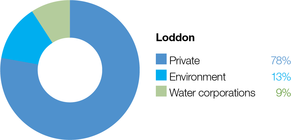
Loddon River (targeting reach 4) |
Winter/spring low flow (50-100 ML/day during June to November)1 | - At 50 ML/day, a low flow will provide a minimum level of continuous flow through the reach and maintain water quality and adequate depth in pools to provide habitat for aquatic plants, waterbugs, fish and rakali (water rats)
- At 100 ML/day:
- increase the water depth for fish, platypus and rakali (water rat) dispersal (especially for male juvenile platypus) to colonise new breeding territory in winter and provide foraging habitat
- prevent silt and fine sediment from settling on submerged wood and other hard surfaces
- inundate a variety of habitats to increase the growth of biofilms and support waterbug productivity
- inundate native fringing bank vegetation to support seed germination and growth and prevent the encroachment of exotic terrestrial plants in the river channel
|       |
Winter/spring low flow trial (100-200 ML/day for one to 30 days during June to November, if triggered by an unregulated flow event) | - Increased longitudinal connectivity by drowning out fish barriers to allow fish to access new habitats
- Inform future works to modify or remove fish barriers
| |
Winter/spring high flow (one high flow of 400- 450 ML/day for 10 days during August to November) | - Provide sufficient velocity to scour accumulated sediment from pools and scour biofilms, promoting the growth of new biofilms and increasing waterbug productivity
- Flush accumulated organic matter from the bank and benches to increase productivity and reduce the risk of a hypoxic blackwater event in summer
- Wet the banks to promote the recruitment and growth of streamside and emergent vegetation
- Stimulate native fish movement and breeding
|  |
Summer/autumn low flow (50 ML/day during December to May)2  | - Maintain an adequate depth in pools for aquatic plants and to provide habitat for waterbugs, fish and rakali (water rats)
- Provide a continuous flow through all reaches
- Maintain water quality throughout most of the reach, except the Loddon River west branch, during warm weather
- Wet the banks and shallow riffles to support the growth of in-stream and fringing non-woody vegetation
| |
Summer/autumn low-flow trial (50-100 ML/day for six weeks during December to May) | - Maintain water quality and mitigate against a hypoxic blackwater event in the Loddon River west branch
- Prevent the emigration of native fish species due to poor water quality
| |
Summer/autumn freshes (three freshes of 100 ML/ day for three days during December to May) | - Increase the water level to promote seed germination and the growth of fringing emergent macrophytes
- Increase connectivity between deep pools to promote the local movement of fish and prompt the dispersal of juvenile platypus in autumn
- Generate sufficient force to flush fine sediment and old biofilms from submerged wood and other hard surfaces, promoting the growth of new biofilms and increasing waterbug productivity
- Freshen water quality and reoxygenate pools
| |
Autumn high flow (one high flow of 400 ML/day for six days3 during March to May) | - Trigger and facilitate the upstream movement of golden perch, silver perch and Murray cod older than one year
- Facilitate the dispersal of juvenile platypus
- Generate sufficient force to flush fine sediment and old biofilms from submerged wood and other hard surfaces, promoting the growth of new biofilms and increasing waterbug productivity
| |
Year-round fresh (trigger- based, 100-200 ML/day as required) Triggers: - dissolved oxygen level is below 5 mg/L
- low or cease-to-flow river conditions
- high water temperatures
| - Destratify pools and improve water quality (increase oxygen levels) along the river in reach 4, ensuring there is adequate oxygen to support aquatic animals (such as native fish and platypus)
|
|
Pyramid Creek and Loddon River (targeting reach 5) |
Year-round low flow (90-300 ML/day at Box Creek regulator) | At 90 ML/day, - the low flow will maintain connectivity between pools, maintain water quality at a level that can support fish and macroinvertebrates and provide habitat for aquatic animals
At 200 ML/day: - increase longitudinal connectivity to allow native fish and platypus to access new habitats
- improve water quality by reducing salinity levels
- increase the wetted area to maintain and promote the growth of fringing emergent (non-woody) vegetation along the lower banks of the channel
At 300 ML/day: - facilitate greater movement for large-bodied native fish
- increase hydrodynamic diversity and improve the quality of flowing habitats
| |
Winter/spring high flow (one high flow of 650 ML/ day at Kerang Weir for 10 days during August to November)4 | - Trigger the migration, spawning and recruitment of native fish species, including Murray cod
- Maintain connectivity between habitats and improve water quality
- Provide sufficient energy to flush accumulated sediment from pools and substrates
| |
Autumn high flow (one high flow of 650 ML/day at Kerang Weir for 10 days3 during March to April)4 | - Trigger and facilitate the upstream movement of golden perch, silver perch and Murray cod older than one year
- Maintain connectivity between habitats and improve water quality
- Facilitate platypus dispersal
- Provide sufficient energy to flush accumulated sediment from pools and substrates
| |
Serpentine Creek (targeting reach 1)5 |
Winter/spring low flow (10-30 ML/day6 during June to November) | At 10 ML/day, - the low flow will maintain connectivity between pools to allow the dispersal of small to medium-bodied native fish
- provide a sufficient flow to maintain water quality by oxygenating pools
- maintain foraging habitat for platypus
- maintain the wetted area to support in-stream aquatic vegetation (such as water ribbons, eel weed and milfoil)
At 20-30 ML/day: - maintain habitat for larger native fish and facilitate movement for aquatic animals
- wet exposed roots, woody debris, emergent vegetation and leaf packs to provide habitat for aquatic animals
- inundates low benches, banks and some secondary channels, supporting increased macroinvertebrate productivity and native fish breeding, including river blackfish breeding
- provide flow variability to maintain the diversity of the fringing vegetation
|
|
Winter/spring fresh (one fresh of 40-120 ML/ day6 for two days during August to November) | - Provide connectivity for fish and waterbugs to access different habitat areas, supporting a diversity of functional feeding groups
- Transport organic matter that has accumulated in the channel to facilitate its breakdown and incorporation into the foodweb, with a low risk of hypoxic blackwater
- Wet the banks to promote the recruitment and growth of streamside and emergent vegetation
- At 120 ML/day:
- maintain the channel form and scour pools
- encourage female platypus to select nesting burrows higher up the bank to reduce the risk of a greater flow later in the year flooding burrows with juveniles in them
- flush accumulated leaf litter from the banks and low benches to reduce the risk of blackwater events during summer
| |
Summer/autumn low flow (10-20 ML/day6 during December to May) | At 10 ML/day: - the low flow will provide connectivity between pools to allow the dispersal of small to medium-bodied native fish
- provide a sufficient flow to maintain water quality by oxygenating pools
- maintain foraging habitat for platypus
- maintain the wetted area to support in-stream aquatic vegetation (such as water ribbons, eel weed and milfoil)
At 20 ML/day: - maintain habitat for larger native fish and facilitate movement of aquatic fauna
- wet exposed roots, leaf packs and woody debris to provide habitat for aquatic animals
| |
Summer/autumn freshes (three freshes of 40 ML/ day6 for two days during December to May) | - Maintain the channel form by inundating benches
- Generate sufficient force to flush fine sediment and old biofilms from submerged wood and other hard surfaces, promoting the growth of new biofilms, increasing waterbug productivity and replenishing the food supply for aquatic animals
- Increase connectivity between pools to promote the local movement of fish and prompt the dispersal of juvenile platypus in autumn
- Provide flow variability to maintain the diversity of fringing vegetation (such as emergent macrophytes)
- Freshen the water to improve its quality by diluting salt, reoxygenating the water and flushing poor-quality water in pools, transporting accumulated nutrients and carbon downstream
| |