Skip to content


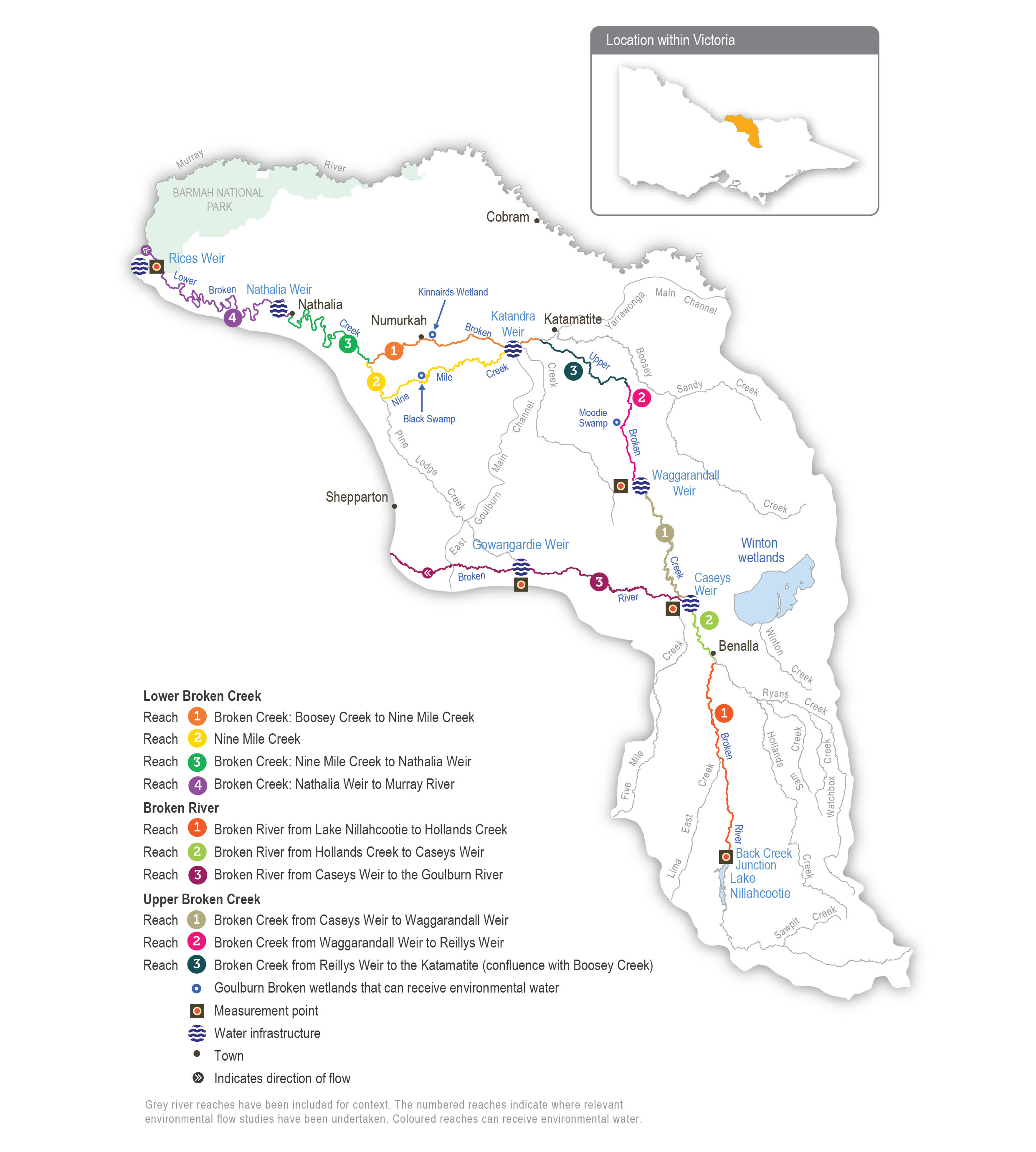
Lower Broken and Nine Mile creeks have been regulated for over a century. Before regulation, the creeks would have had most of their flow in winter/spring and contracted to isolated pools or dried out during summer/autumn. The adjacent floodplain would have also flooded regularly. The creeks now have numerous weirs that maintain a relatively constant water level from mid-August until mid-May to support irrigated agriculture and little flow during the non-irrigation season. These modifications have changed the way native species use the creek and have introduced invasive species such as arrowhead. Previously, native fish would have moved into the creek when it was flowing and returned to the Murray River as it dried. Both creeks now provide year-round habitat for native fish, and fish passage structures allow fish to move between weir pools. Water for the environment is used to support these permanent fish habitats by providing flows to trigger fish movement and support fish passage, encourage the growth of native plants, promote in-stream productivity, control water quality and flush the water fern azolla as necessary.

Regulated water is delivered to lower Broken Creek from the Goulburn and Murray systems via the irrigation channel network. Lower Broken Creek is operated separately from upper Broken Creek and Broken River, which are both supplied from Lake Nillahcootie on upper Broken River.

Water for the environment can be provided to lower Broken Creek from the Goulburn system through the East Goulburn Main Channel and from the Murray system through the Yarrawonga Main Channel. Water is released into lower Broken Creek from several irrigation regulators along the length of lower Broken Creek. The main priority for environmental flows in the lower Broken Creek system is to maintain minimum flows throughout the year. Particular attention is given to reaches 1 and 2 during the non-irrigation season when flow can stop. The next priority is to deliver freshes in winter/spring to trigger fish movement and spawning, maintain water quality and manage azolla accumulations in reaches 3 and 4. The measurement point for environmental flows in lower Broken Creek is at Rices Weir.

Some of the environmental flow targets for lower Broken Creek are partly or wholly met by operational water releases — inter-valley transfers (IVTs) from the Goulburn to the Murray or Barmah Choke bypass flows — that are delivered to meet downstream demands. These operational deliveries mainly occur during peak irrigation demand periods between spring and autumn. Water for the environment may be used to supplement these operational releases and to deliver recommended flow components that are not met by operational releases.

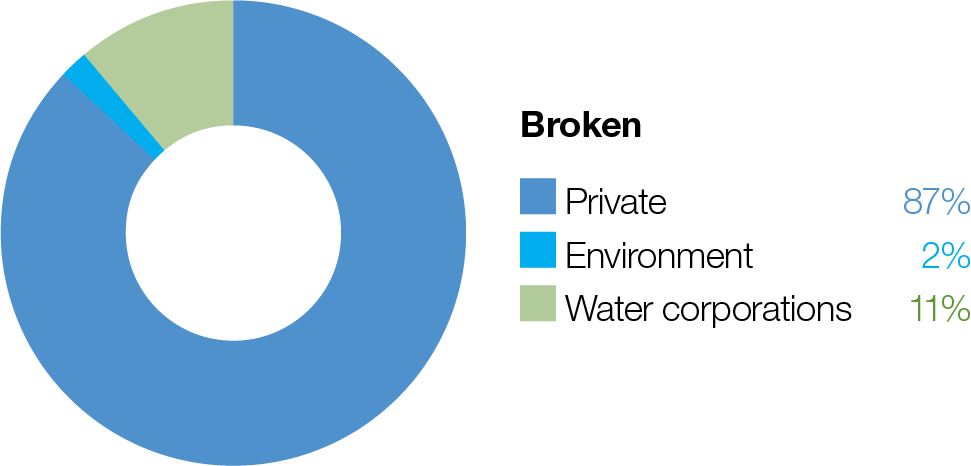
Proportion of water entitlements in the Broken system held by private users, water corporations and environmental water holders on 30 June 2020

Traditional Owners
Storage manager
Environmental water holder

System map

Environmental watering objectives in the Lower Broken Creek

Fish icon
Protect and increase native fish populations including the threatened Murray cod, golden perch and silver perch
Platypus icon
Protect platypus populations, particularly outside the irrigation season

Protect rakali (water rat) populations, particularly outside the irrigation season
Protect turtle populations, particularly outside the irrigation season
Plant icon
Avoid the excessive build-up of azolla.
Maintain the cover and condition of native in-stream and littoral vegetation communities
Insect icon
Increase the diversity and abundance of waterbug populations
Water icon
Maintain oxygen levels suitable for aquatic animals

Environmental values

Lower Broken Creek and Nine Mile Creek support a diverse and abundant native fish community, including the threatened Murray cod, golden perch, silver perch, unspecked hardyhead and Murray-Darling rainbowfish.

Sections of lower Broken and Nine Mile creeks have been reserved as state park and natural feature reserves. The associated floodplain and wetland habitats support box-dominated grassy woodland communities and numerous species of state and national conservation significance, including river swamp wallaby grass and the Australasian bittern.

Traditional Owner cultural values and uses

Goulburn Broken CMA consulted with the Yorta Yorta Nation Aboriginal Corporation during the planning of deliveries of water for the environment in lower Broken Creek. The following cultural values were identified for lower Broken Creek in 2021. The YYNAC were again consulted on this for the 2022-23 watering season.

“The Broken Creek holds many cultural values. Common reed contained within the slack water provides important material for tools while also providing refuge for culturally important fish species (large and small-bodied). The creek also has significant stands of old growth river red gum containing important habitat and exhibiting scars made from carving out canoes and coolamons.”

The Yorta Yorta Nation Aboriginal Corporation continues to pursue the Yorta Yorta People’s inherent rights to water for Country to improve their spiritual, cultural, environmental, social and economic needs, in line with the Yorta Yorta Whole-Of- Country Plan 2021-2030.

The environmental objectives in lower Broken Creek seasonal watering proposal are supported by Yorta Yorta and align with their values of caring for Country. Flows have been specifically targeted to support in-stream vegetation and native fish, along with other aquatic plants and animals. Goulburn Broken CMA will continue to work with Yorta Yorta people to identify how the management of water for the environment can best support water for their Country, enhancing cultural values.

The Yorta Yorta Nation Aboriginal Corporation has raised concerns about flow regulation in all their waterways, which is affecting their Country and cultural knowledge.

Social, recreational and economic values and uses

In planning the potential watering actions in Table 5.5.3, Goulburn Broken CMA considered how environmental flows could support values and uses, including:

  • water-based recreation (such as canoeing, fishing, game hunting and kayaking)
  • riverside recreation and amenity (such as aesthetic and amenity values that are particularly important for the community’s mental health and wellbeing during dry periods and passive recreation)
  • community events and tourism
  • socio-economic benefits (such as consumptive water users, Goulburn-Murray Water irrigators and diverters and Goulburn Valley Water customers)

Recent conditions

The Goulburn Broken region experienced average to above-average rainfall and temperatures throughout most of 2021-22 as a La Niña weather event influenced climate conditions across eastern Australia. Winter/spring rainfall in the Broken catchment provided unregulated inflows from upper Broken Creek to the south and Boosey Creek to the east. These were the highest unregulated inflows to lower Broken Creek since 2016. Allocations against high-reliability water entitlements in the Goulburn and Murray storages that supply lower Broken Creek reached 100 percent by October 2021, and low-reliability entitlements in the Murray system reached 100 percent by February 2022.

Deliveries of water for the environment in lower Broken Creek were managed in line with an average climate scenario in 2021-22. IVTs and Murray Bypass flows (which often meet environmental flow targets) were not delivered via lower Broken Creek throughout spring, summer and autumn due to high, unregulated flow in the Murray River. This meant greater volumes of water for the environment were required to achieve environmental objectives. Planned watering actions were largely achieved between mid-August 2021 and mid-May 2022, but maintenance works on the Yarrawonga Main Channel and the East Goulburn Main Channel during July 2021 meant the winter low-flow target of 40 ML per day was not met. Fishways were also closed during this period to maintain water levels in the weir pools, and other sections of the creek contracted to a series of shallow pools, which provided limited habitat for native fish and platypus. This was the fourth consecutive year that maintenance works during the irrigation shut-down period have limited deliveries of water for the environment in lower Broken Creek.

Oxygen levels in lower Broken Creek dropped below the critical level of 4 mg/L during hot weather on four occasions in summer. Environmental flows were increased to 350 ML per day under emergency watering provisions to reduce stress on resident fish populations. Water for the environment was also used to dilute a hypoxic blackwater event that was caused by a heavy rain event in late January.

There is little ecological monitoring in lower Broken Creek, but members of the Broken Environmental Water Advisory Group and other community members have reported a marked improvement in water quality since deliveries of water for the environment started in 2010-11. There are also anecdotal reports the native fish population has improved. Some monitoring in lower Broken Creek is planned during 2022 to inform the Goulburn to Murray Trade Rule Review. The monitoring will investigate how different flow patterns affect vegetation and erosion rates on the riverbank, and it will inform future creek operations.

Scope of environmental planning

Table 1 Potential environmental watering actions and objectives for lower Broken Creek

Potential environmental watering action

Expected watering effects

Environmental objectives

Winter low flow (20-40 ML/day during May to August)*

  • Provide native fish with passage through fish ladders
  • Provide suitable foraging habitat for platypus and rakali (water rats), and support the conditioning of females in preparation for the breeding season
  • Provide habitat for turtles, including protection from exposure during their winter dormancy
  • Provide flowing-water habitat and avoid winter drying of weir pools for fish, vegetation, waterbugs, platypus and turtles
  • Maintain water over submerged aquatic plants so they are protected from drying and frost
  • Reduce the stagnation of weir pools
Fish iconPlatypus iconTurtle iconPlant iconInsect iconWater drop icon

Spring/summer/autumn low flow (70-250 ML/ day in reaches 1 and 2 and 200-450 ML/day in reaches 3 and 4 during August to May)

  • Provide habitat for native fish, platypus, rakali, turtles and waterbugs
  • Support the movement and recruitment of fish
  • Maintain oxygen levels in summer
  • Additional benefits when delivered from December to February (at 250-450 ML/day):
    • mobilise azolla and increase oxygen levels during high-risk periods
Fish iconPlatypus iconTurtle iconPlant iconInsect iconWater drop icon

Winter/spring fresh(es) (one to three freshes of 300-450 ML/day for one to two weeks during July to November)

  • Flush and mobilise azolla if it has accumulated to maintain water quality
  • Trigger the movement and spawning of fish
  • Encourage the germination and growth of littoral and in-stream vegetation
  • Reduce the stagnation of weir pools
Fish iconPlant iconInsect iconWater drop icon

* This flow may be difficult to achieve when channel maintenance work is being completed. If maintenance work is required, waterway managers will work with the storage manager to minimise impacts where possible. Possible mitigation actions include closing fishways to maintain water in weir pools and scheduling works to minimise the duration of impacts on flow.

Scenario planning

Table 5.5.4 outlines potential environmental watering and expected water use under a range of planning scenarios.

The high degree of regulation in the lower Broken Creek system means flow patterns in the lower Broken and Nine Mile creeks are the same under all climate scenarios. Water for the environment in the lower Broken Creek system is primarily used to guard against reduced flow during the non-irrigation season.

Potential watering actions under all climate scenarios include maintaining flow above 40 ML per day outside the irrigation season, ameliorating sudden fluctuations in irrigation demand during the irrigation season and delivering spring freshes to trigger fish movement or flush excessive accumulations of azolla. Goulburn Broken CMA will monitor water quality throughout the year, and it may increase flow to the upper end of the recommended range in Table 5.5.3 if oxygen levels drop below 4.0 mg/L. The total volume of water for the environment that will be needed to achieve planned watering actions in 2022-23 will vary depending on operational deliveries (including IVTs) and the sizes and durations of any unregulated flow events. A carryover target of 5,000 ML applies under all climate scenarios to ensure minimum low flow and a small fresh can be delivered early in 2023-24.

Planning scenario table

Table 5.5.4 Potential environmental watering for lower Broken Creek under a range of planning scenarios

Planning scenario

Drought

Dry

Average

Wet

Expected river conditions

  • No unregulated flow
  • Some unregulated flow in winter
  • No unregulated flow throughout the irrigation season (mid-August to May)
  • No diversion of unregulated Murray River flow is available
  • Unregulated flow in winter/spring
  • Unregulated flow is unlikely from October to May
  • Diversion of unregulated Murray River flow is available from mid- August to October
  • Unregulated flow is likely in winter/ spring
  • Unregulated flow is possible from November to May
  • Diversion of unregulated Murray River flow available from mid-August to November

Potential environmental watering – tier 1 (high priorities)1

  • Winter low flow
  • Spring/summer/autumn low flow
  • Winter/spring freshes

Possible volume of water for the

environment required to achieve objectives

  • 80,000 ML

Priority carryover requirements for 2023-24

  • 5,000 ML

1 Tier 1 potential environmental watering for lower Broken Creek is not classified as tier 1a or 1b because the water available for use is shared across various systems, and it is not possible to reliably determine the supply specifically available for lower Broken Creek.

Engagement

Table 2 shows the partners and stakeholder organisations with which the Goulburn Broken CMA engaged when preparing the Broken system seasonal watering proposal.

Seasonal watering proposals are informed by longer-term plans such as regional catchment strategies, regional waterway strategies and environmental water management plans and other studies. These plans incorporate a range of environmental, cultural, social and economic perspectives and longer term integrated catchment and waterway management objectives. For further details, refer to the Goulburn Broken Regional Catchment Strategy and Goulburn Broken Waterway Strategy.

Table 2 Partners and stakeholders engaged in developing the Broken system seasonal watering proposal

Partner and stakeholder engagement
  • Broken Boosey Conservation Management Network
  • Broken Creek Field Naturalists Club
  • Goulburn Murray Landcare
  • Commonwealth Environmental Water Office
  • Goulburn- Murray Water
  • Parks Victoria
  • Moira Shire Council
  • Individual landholders who are on the Broken Environmental Water Advisory Group
  • Individual community members on the Broken Environmental Water Advisory Group
  • Nathalia Angling Club
  • Numurkah Fishing Club
  • Taungurung Land and Waters Council
  • Yorta Yorta Nation Aboriginal Corporation

Page last updated: 01/12/22