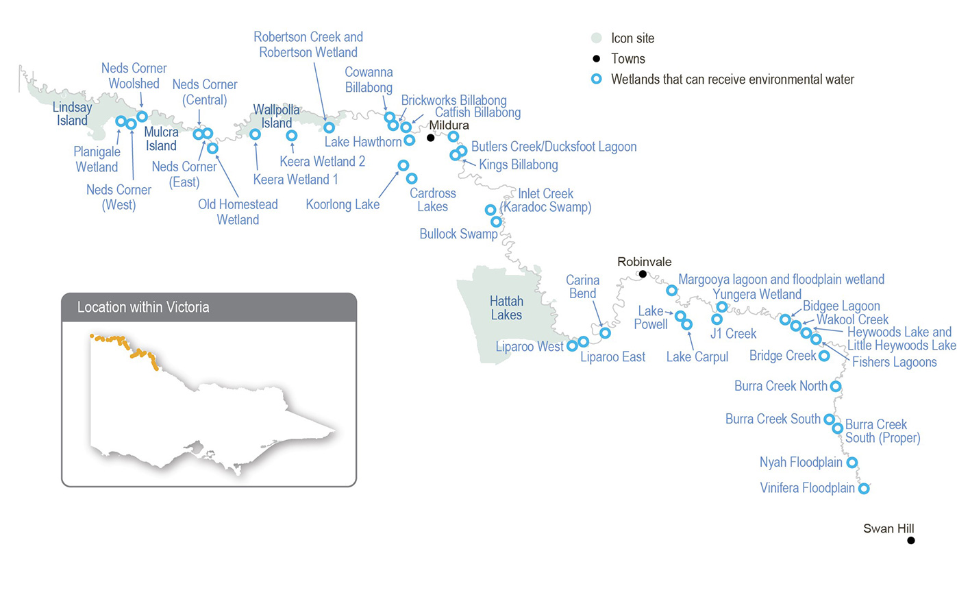
Skip to content


Regulation and diversion of Murray River flows have substantially reduced the frequency and duration of the high river flows that would naturally water the lower Murray wetlands. This change to the water regime has been exacerbated by climate change and has reduced the variety and condition of environmental values associated with billabongs and other floodplain habitats.

Water for the environment can be delivered to some wetlands in the region through direct pumping from the Murray River and/ or the use of irrigation supply infrastructure. Most wetlands that receive environmental flows can be managed independently of each other.

Traditional Owners

System map

Environmental watering objectives in the Lower Murray wetlands

Connected icon
Promote carbon and nutrient cycling to enable wetland processes for food webs
Fish icon
Maintain and/or increase populations of native fish in permanent wetlands
Frog icon
Maintain and/or grow populations of native frogs, including the endangered growling grass frog
Plant icon
Increase the diversity, extent and abundance of wetland plants.
Improve the condition of river red gums, black box and lignum communities
bird icon
Provide feeding and breeding habitat for a range of waterbird species, including threatened and migratory species and colonial nesting species (such as egrets)

Traditional Owner cultural values and uses

Watering of the lower Murray wetlands supports cultural values such as traditional food sources and medicines and important species, and it provides opportunities for teaching, learning and storytelling.

On proposed 2022-23 watering of the lower Murray wetlands, Mallee CMA engaged with the First People of the Millewa-Mallee Aboriginal Corporation (FPMMAC) comprised of Latji Latji and Ngintait Traditional Owners (Traditional Owners from Hattah to the South Australian border). Mallee CMA also engaged with Latji Latji Mumthelang and representatives from Culpra Millee and Munatunga.

Traditional Owner groups invited to discussions included Tati Tati, Wamba Wemba, Wadi Wadi, Weki Weki and Nyeri Nyeri.

Tati Tati wish to express their lack of representation in no way is a reflection their lack of interest or cultural responsibility in caring for wetlands on Tati Tati Country. It does, however, reflect Tati Tati’s deliberate shift to only engaging organisations that demonstrate a commitment to upholding cultural safety. Tati Tati will continue to look to the future to partner with organisations transitioning to First Nations empowerment – not engagement.

Discussions covered a range of options for how environmental flows could be delivered in 2022-2023 and what the traditional ecological needs are in the current climate. Discussions also covered how the planning process works, as some community members had not participated in previous years. The values, knowledge and concerns identified in these discussions have supported the Mallee CMA’s planning for wetland watering across the lower Murray region.

Elders from the Nyah Floodplain region (Culpra Millee) said that watering creeks across the floodplain is good for their communities, enabling many generations to get out on Country while water is in the creeks. They said they would like to be involved in planning for water for the environment from the start and all the way through: from before water is pumped to when water flows in the creeks. Opportunities to foster intergenerational education and the passing down of cultural knowledge are also very important.

Increasing the involvement of Traditional Owners in the planning and management of water for the environment and ultimately providing opportunities to progress towards self-determination within the environmental watering program is a core commitment of the VEWH and its agency partners. This is reinforced by a range of legislative and policy commitments, including the Water Act 1989, the Victorian Aboriginal Affairs Framework, the 2016 Water for Victoria and in some cases, agreements under the Traditional Owner Settlement Act 2010.

Where Traditional Owners are more deeply involved in the planning and/or delivery of environmental flows for a particular site, their contribution is acknowledged in Table 5.2.14 with an icon. The use of this icon is not intended to indicate that these activities are meeting all the needs of Traditional Owners but is incorporated in the spirit of valuing their contribution and indicating progress towards deeper involvement.

Billabong icons

Watering planned and/or delivered in partnership with Traditional Owners to support cultural values and uses

Robertson Creek is an area of high cultural significance that is being degraded as drying vegetation dies and wind erodes the landscape. The First People of the Millewa-Mallee Aboriginal Corporation is undertaking a program of restoration and protection work at the site. An environmental flow was delivered to the creek in spring 2020-21 and again in 2021-22 to complement the restoration and protection objectives. This has helped improve the condition of trees and shrubs and helped return and protect cultural values which are important for community learning, teaching and overall wellbeing. An environmental flow is planned for Robertson Creek in 2022-23 in all scenarios except drought. This will build on outcomes from previous watering by further improving the condition of the vegetation and increasing protection against wind. It will also support the revegetation of native trees, shrubs and grasses.

Social, recreational and economic values and uses

In planning the potential watering actions in Table 5.2.14, Mallee CMA considered how environmental flows could support values and uses, including:

  • water-based recreation (such as canoeing, fishing and kayaking)
  • riverside recreation and amenity (such as bike riding, birdwatching, bushwalking, camping, geocaching, photography and running)
  • community events and tourism (such as day trips and sightseeing; education programs for school, TAFE and university students; citizen science projects about birds, frogs and bats; and sporting events)
  • socio-economic benefits (such as economic benefits for businesses in the accommodation, beekeeping, food and beverage, ecotourism, hospitality and retail sectors; creating a focal point for socialising; and providing natural, green spaces for the local community).

Recent conditions

Rainfall across the lower Murray floodplain in 2021-22 was close to or slightly above the long-term average. Rainfall in the upper Murray and Murrumbidgee catchments was significantly greater than average, and it delivered sustained periods of unregulated flow in the Murray River. Increased flow in the Murray River during spring and early summer naturally inundated some of the low-lying wetlands on the lower Murray floodplain.

In 2021-22, allocations against high-reliability water shares reached 52 percent in August and 100 percent in October. Low- reliability water shares began receiving allocations in December and reached their full allocations in February. This is the first time Murray seasonal determinations reached maximum availability since the introduction of the current entitlement products in 2007. Spills from Hume Dam resulted in the deduction of most spillable carryover from 2020-21. Section 5.2 has more information about the resource position of water for the environment in the Victorian Murray system during 2021-22.

Deliveries of water for the environment for the Lower Murray wetlands were managed in line with a dry climate scenario at the start of 2021-22 but shifted to an average scenario in spring in response to increasing flows in the Murray River.

Most of the potential watering actions planned in 2021-22 were fully achieved. Environmental flow objectives at Nyah Floodplain, Vinifera Floodplain, Bidgee Lagoons and Fishers Lagoon were met by natural inflows from the Murray River. Run-off from local rainfall helped meet environmental watering objectives for Murray hardyhead at Lake Koorlong and Lake Hawthorn, which reduced the total volume of water for the environment that was pumped to those sites. Water for the environment was delivered as planned to Robertson’s Creek, Brickworks Billabong, Burra Creek South and Burra Creek South Proper. Since 2018-19, Lake Carpul and Lake Powell have remained dry to support dry-phase ecosystem processes.

The only planned environmental watering action for the lower Murray wetlands that was not achieved in 2021-22 was an autumn fill at Burra Creek North. Watering at the site currently relies on temporary pumping, but the proposed pumping site was inaccessible in autumn due to private works. New water delivery infrastructure is due to be built at Burra Creek North during 2022-23 as part of the Victorian Murray Floodplain Restoration Project (VMFRP), and the site will be prioritised for watering in 2023-24.

Scope of environmental watering

Table 1 Potential environmental watering actions, expected watering effects and associated environmental objectives for the lower Murray wetlands

Potential environmental watering action

Expected watering effects

Environmental objectives

Brickworks Billabong (top up in spring, top- ups as required over summer/autumn)

  • Maintain water levels (the target water level is between 30.8 m AHD and 31.6 m AHD) to inundate benthic herblands, including ruppia beds, to provide nursery habitat for Murray hardyhead and provide high levels of aquatic productivity
  • Maintain water quality suitable for Murray hardyhead
  • Provide shallow-water habitat and exposed mudflats to support foraging and resting of waterbirds, including migratory waterbirds
Fish iconPlant iconHeron icon

Catfish Billabong (top up winter/spring)

  • Fill to 33.5 m AHD to inundate fringing woodland vegetation to improve condition and recruitment
  • Allow water level to draw down over summer and autumn to:
    • promote the growth of a range of aquatic macrophytes that favour different water depth and inundation patterns
    • provide suitable foraging conditions for wading shorebirds
  • Maintain water levels above 30.8 m AHD to maintain permanent habitat for large-bodied and small-bodied native fish
Fish iconPlant iconHeron icon

Heywood’s Lake (fill in autumn)

  • Fill to 56.8 m AHD to inundate fringing black box to stimulate growth and flowering to improve condition and recruitment
  • Provide a range of temporary open-water and shallow-water habitats to trigger the growth of various aquatic macrophytes and provide feeding and breeding opportunities for a variety of waterbirds

Plant iconHeron icon

Koorlong Lake (fill in spring, top-ups as required)

  • Increase and maintain the water level (the target water level is between 36.7 m AHD and 38.0 m AHD) to support the growth of saline aquatic vegetation, including ruppia, to provide nursery habitat for Murray hardyhead and provide high levels of aquatic productivity
  • Maintain water levels within a 30 cm range to provide feeding resources for shorebirds and to maintain the Murray hardyhead population

Fish iconPlant iconHeron icon

Lake Carpul (fill in spring)

  • Provide a range of open-water, shallow-water and emergent-vegetation habitats for water-dependent birds to support breeding and feeding opportunities
  • Inundate and wet outer fringing river red gum, black box, lignum and vegetation communities (the target water level is 52.23 m AHD) to improve their condition
  • Mobilise carbon and nutrients within the wetland to support wetland processes

Connected iconPlant iconHeron icon

Lake Hawthorn (fill in spring, top-ups as required)

  • Achieve a target water level between 33 m AHD and 33.3 m AHD to:
    • increase and maintain a water level to encourage the germination and growth of ruppia to provide nursery habitat for Murray hardyhead and visitation by shorebirds
    • maintain the water level within a 30 cm range to provide feeding resources for shorebirds and to maintain the Murray hardyhead population

Fish iconPlant iconHeron icon

Lake Powell (fill in spring)

  • Provide a range of open-water, shallow-water and emergent-vegetation habitats for water-dependent birds to support breeding and feeding opportunities
  • Inundate and wet fringing river red gum, black box, lignum and vegetation communities (the target water level is 51.05 m AHD) to improve their condition
  • Mobilise carbon and nutrients within the wetland to support wetland processes

Connected iconPlant iconHeron icon

Little Heywood’s Lake (fill in autumn)
  • Fill to 56.8 m AHD to inundate the fringing black box community to stimulate its growth and flowering to improve condition and recruitment
  • Provide a range of temporary open-water, shallow-water and emergent- vegetation habitats to provide feeding and breeding opportunities for a variety of waterbirds

Plant iconHeron icon

Nyah Floodplain (fill in autumn)

  • Inundate the base and littoral zone of Parnee Malloo Creek (the target water level is 63.2 m AHD) to support plant communities
  • Improve the condition of vegetation communities to provide a range of habitats and feeding and breeding resources for birds and frogs
  • Inundate the floodplain adjacent to Parnee Malloo Creek to promote the growth of herb and shrub layers
  • Inundate river red gum to improve their condition
  • Mobilise carbon and nutrients to promote chemical and biological processes

Connected iconFrog iconPlant iconHeron icon

Robertson Creek (top up in spring)

Billabong icon

  • Wet fringing river red gum, black box, lignum and vegetation communities (the target water level is 30.4 m AHD) to improve their condition
  • Provide lateral spread of freshwater to refresh local groundwater to support the condition of trees not directly inundated
  • Provide a range of open-water, shallow-water and inundated lignum habitats to provide waterbird feeding opportunities and help protect the highly culturally significant site in the adjacent landscape

Plant iconHeron icon

Robertson Wetland (partial fill in spring)
  • Wet fringing river red gum, black box, lignum and vegetation communities (the target water level is 28.4-28.8 m AHD) to improve their condition
  • Inundate cane grass beds to improve their condition and resilience
  • Provide a range of open-water, shallow-water and inundated lignum habitat to provide waterbird feeding opportunities

Plant iconHeron icon

Scenario planning

Table 5.2.15 outlines potential environmental watering and expected water use under a range of planning scenarios.

Brickworks Billabong, Catfish Billabong, Koorlong Lake and Lake Hawthorn are priorities for watering in 2022-23 under all climate scenarios. Brickworks Billabong, Koorlong Lake and Lake Hawthorn support endangered populations of Murray hardyhead and require top-ups each year to ensure salinity levels are maintained within an acceptable range to support submerged vegetation that provides habitat for this species. Catfish Billabong is a new site that supports populations of native fish and wading shorebirds. A new regulator is being built at Catfish Billabong, and watering is prioritised at this site under all scenarios to test the capacity of the new infrastructure to achieve the recommended watering regime.

Nyah Floodplain, Robertson Creek and Robertson Wetland are priority watering sites under dry, average and wet climate scenarios. Nyah Floodplain dried between 2018-19 and 2020-21 and was inundated by unregulated flows in the Murray River during 2021-22. Vegetation at Nyah Floodplain will benefit from a second inundation in two years, which will improve the condition of the site ahead of proposed construction works as part of the VMFRP that will prevent deliveries of water for the environment in 2023-24. Deliveries of water for the environment at Robertson Creek in 2020-21 and 2021-22 have improved the condition of fringing vegetation, including black box and red gum and the waterbird population. Watering the site in 2022- 23 aims to consolidate these environmental outcomes and build resilience for future dry conditions. Robertson Wetland was partially inundated by unregulated flows in the Murray River during 2021-22, but most of the wetland has not been inundated since the 2016 floods. Watering at Robertson Wetland in 2022-23 will aim to improve the condition of fringing river red gum that require inundation between four and six years out of ten for optimal condition. Nyah Floodplain and Robertson Wetland may be watered naturally under a wet scenario if the Murray River floods.

Given natural inundation and deliveries of water for the environment achieved watering requirements for most sites on the lower floodplain in 2021-22, the plan under average and wet scenarios is to water sites higher on the floodplain that have exceeded their recommended drying phase. Targeted sites include Lake Carpul and Lake Powell (dry since 2017) and Heywood’s Lake and Little Heywood’s Lake (dry since 2015). It will be important to deliver water to these sites in 2022-23 where possible because VMFRP construction works will likely prevent them from being actively watered in 2023-24.

Bidgee Lagoons, Fishers Lagoon, Bullock Swamp, Burra Creek South, Burra Creek South Proper and Vinifera Floodplain will be allowed to draw down during 2022-23 (unless they are naturally flooded) to support dry-phase ecosystem processes in accordance with recommendations in their management plans. At Burra Creek South and Burra Creek South Proper, this dry- phase period aligns with planned construction works through VMFRP, which will be completed in 2024-25.

Planning scenario table

Table 5.2.15 Potential environmental watering for the lower Murray wetlands under a range of planning scenarios

Planning scenario

Drought

Dry

Average

Wet

Expected river conditions

  • Natural flow in the Murray River is too low to connect to wetlands
  • Wetlands rely on the delivery of water for the environment; very low rainfall year-round and extremely hot and dry conditions in summer/autumn cause substantial wetland drying
  • Short periods of high flow in the Murray River are possible, but overbank flow to wetlands is unlikely; low rainfall and very warm summer/autumn
  • Sustained periods of high flow in the Murray River in late winter and early spring may wet some low-lying wetlands, but most wetlands will rely on water for the environment
  • Local rainfall may be high and provide run-off to some wetlands
  • Lengthy periods of high flow and floods with major spills from storages, resulting in widespread wetting of the floodplain and most wetlands
  • Some reliance on water for the environment to achieve target water levels
  • Local rainfall may be high and will provide run-off to most wetlands

Potential environmental watering – tier 1 (high priorities)1

  • Brickworks Billabong
  • Catfish Billabong
  • Koorlong Lake
  • Lake Hawthorn
  • Brickworks Billabong
  • Catfish Billabong
  • Koorlong Lake
  • Lake Hawthorn
  • Nyah Floodplain
  • Robertson Creek
  • Robertson Wetland
  • Brickworks Billabong
  • Catfish Billabong
  • Heywood’s Lake
  • Koorlong Lake
  • Lake Carpul
  • Lake Hawthorn
  • Lake Powell
  • Little Heywood’s Lake
  • Nyah Floodplain
  • Robertson Creek
  • Robertson Wetland
  • Brickworks Billabong
  • Catfish Billabong
  • Heywood’s Lake
  • Koorlong Lake
  • Lake Carpul
  • Lake Hawthorn
  • Lake Powell
  • Little Heywood’s Lake
  • Nyah Floodplain
  • Robertson Creek
  • Robertson Wetland

Possible volume of water for the environment required to achieve objectives1

  • 2,800 ML (tier 1)
  • 6,000 ML (tier 1)
  • 13,300 ML (tier 1)
  • 10,800 ML (tier 1)

Priority carryover requirements for 2023-24

  • N/A
   

1 Tier 1 potential environmental watering at the lower Murray wetlands is not classified as tier 1a or 1b because the water available for use is shared across various systems, and it is not possible to reliably determine the supply specifically available for the lower Murray wetlands.

Engagement

Table 2 shows the partners and stakeholder organisations with which Mallee CMA engaged when preparing the lower Murray wetlands seasonal watering proposal.

Seasonal watering proposals are informed by longer-term regional catchment strategies, regional waterway strategies, environmental flow studies, water management plans and other studies. These incorporate a range of environmental, cultural, social and economic perspectives and longerterm integrated catchment and waterway management objectives. For further details, refer to the Mallee Regional Catchment Strategy and the Mallee Waterway Strategy

Table 2 Partners and stakeholders engaged in developing the lower Murray wetlands seasonal watering proposal

Partner and stakeholder engagement
  • Cabarita Inc.
  • Community members on the Mallee CMA Land and Water Advisory Committee
  • Local Landcare groups
  • Mid-Murray Field Naturalists
  • Goulburn-Murray Water
  • Parks Victoria
  • Department of Environment Land, Water and Planning (Fire Forest and Regions)
  • Department of Environment Land, Water and Planning (Water and Catchments)
  • Lower Murray Water
  • Loddon Mallee Waste and Resource Recovery Group
  • Mildura Rural City Council
  • Swan Hill Rural City Council
  • Trust for Nature
  • Local landowner
  • Sunraysia Apiarist Association
  • Mallee Tours
  • Murray Offroad Adventures
  • Visit Mildura
  • Wildside Outdoors
  • Birdlife Mildura
  • Four-wheel drive club
  • Mildura Information Centre
  • Sunraysia Bushwalkers
  • Mallee CMA Land and Water Advisory Committee
  • Arthur Rylah Institute (Department of Environment, Land, Water and Planning)
  • Robinvale Elders and communties
  • First People of the Millewa-Mallee Aboriginal Corporation

Page last updated: 01/07/22