Skip to content


The WMPP replaced stock and domestic supply dams with tanks, and the open-channel distribution system with pipelines, to improve water efficiency. A portion of the water savings from the WMPP was converted to an environmental entitlement to

improve the condition of the area’s flow-stressed rivers, creeks and wetlands; the rest was used to create regional development opportunities and boost the reliability of supply for other users. The WMPP reduced the amount of open-water habitat in largely agricultural areas that were formerly supplied by the open-channel system, so a separate 1,000 ML environmental entitlement was created to water some of the wetlands that were previously supplied through the channel system. There are 52 priority wetlands that can receive water from this environmental entitlement.

Water for the environment can only be delivered to the wetlands when there is sufficient capacity in the Wimmera-Mallee pipeline system, which can be affected by demand from other pipeline customers. The North Central, Mallee and Wimmera CMAs work closely with GWMWater and land managers (including Parks Victoria, the Department of Environment, Land, Water and Planning and private landowners) to take account of pipeline capacity constraints when ordering environmental deliveries to wetlands.

Traditional Owners
Storage manager
Environmental water holder

System map

Environmental watering objectives in the Wimmera-Mallee wetlands

Frog icon
Maintain and increase the population of frogs
Maintain and increase the population of turtles
Kangaroo icon
Provide watering holes for native animals and terrestrial birds across the landscape
Plant icon
Maintain and improve the condition of aquatic and fringing plants, including lignum, river red gum and black box communities.
Improve the diversity of wetland vegetation communities
bird icon
Maintain and increase populations of waterbirds and other native birds by providing resting, feeding and breeding habitat

Environmental values

There are many wetland types in the Wimmera-Mallee wetlands system, including freshwater meadows, open freshwater lakes and freshwater marshes. This diversity provides a range of different wetland habitats for plants and animals across the Wimmera-Mallee region. The wetlands also vary in size and support different vegetation communities. Some support native waterbird populations, including brolgas, egrets, blue-billed ducks, freckled ducks, Australian painted snipes and glossy ibis. The vulnerable growling grass frog, turtles and many other native animals may use the wetlands as drought refuges and drinking holes. Rare and vulnerable vegetation species (such as spiny lignum, ridged water-milfoil, chariot wheels and cane grass (Eragrostis australasica)) are also present in some wetlands.

Traditional Owner cultural values and uses

Spanning a broad geographic area, several Wimmera-Mallee wetlands show indications of the longstanding cultural heritage and importance of these sites to the Traditional Owners of the region, including but not limited to Barapa Barapa Traditional Owners and other Traditional Owner groups represented by the Barengi Gadjin Land Council and the Dja Dja Wurrung Clans Aboriginal Corporation (trading as DJAARA). Some sites have artefacts and scar trees recorded in or adjacent to them, and further cultural surveys could better inform management of water for the environment at those sites.

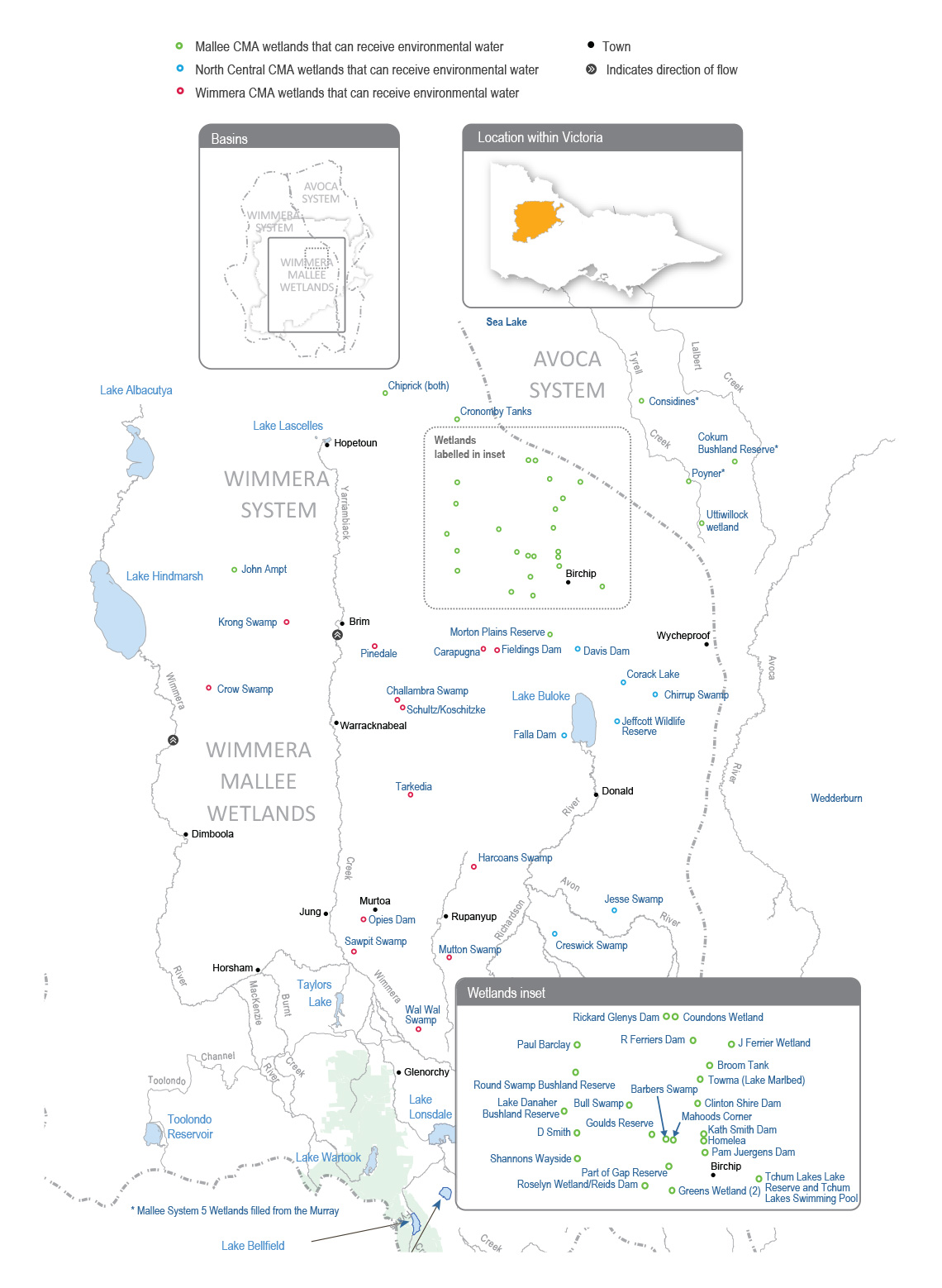
The Barengi Gadjin Land Council is the Registered Aboriginal Party for a significant land area of the Wimmera-Mallee wetlands. The Barengi Gadjin Land Council represents the Wotjobaluk, Jaadwa, Jadawadjali, Wergaia and Jupagalk peoples.

In recent years, Barengi Gadjin Land Council Aboriginal Water Officers and Wimmera CMA have undertaken monitoring at Sawpit Swamp, Wal Wal Swamp, Carapugna and Mutton Swamp helping to understand environmental flow deliveries and values at the sites.

Barengi Gadjin Land Council and North Central CMA have discussed opportunities for projects that facilitate reconnection with and healing of Country. Recent meetings have highlighted several areas where collaboration is possible including on-Country events and revegetation projects. In 2022, Barengi Gadjin Land Council and North Central CMA are intending to undertake cultural values assessments at the Wimmera Mallee Pipeline wetland sites.

The Barengi Gadjin Land Council has discussed the significance of the wetlands and their aspiration to undertake work at these sites in future, and provided the following statement to Mallee CMA when discussing environmental watering:

The Wimmera-Mallee is living cultural landscape and there is a lack of recorded data regarding the cultural values over many sections of the Wimmera-Mallee Pipeline. Several highly significant places are outlined through our Country Plan, but like all places across our Country, the rivers, creeks, lakes, wetlands and swamps, and all other landscape features in this area are of high cultural significance. We wish to care for Country again through our traditional land management practices and revive and share the ancient narrative of this area. Mapping the cultural values of places along the Wimmera-Mallee pipeline will be essential in contributing to integrated catchment management.

We are unable to identify places of particular cultural values and uses confidently until Aboriginal Water Assessment/ Cultural Heritage Surveys are systematically undertaken across Wimmera-Mallee pipeline sites. All of the swamps, wetlands and soaks of this area are of high cultural significance as they are linked to Traditional trading routes that extend in all directions. It is essential that all of these places are managed correctly and water quality and biodiversity are improved (pers. comm. Barengi Gadjin Land Council, April 2021).

Further discussions with Barengi Gadjin Land Council are forthcoming regarding the cultural values and uses in and around the Wimmera Mallee Pipeline wetlands (within the Mallee catchment), with an onsite visit planned for May 2022 (during the drafting of this plan).

Social, recreational and economic values and uses

In planning the potential watering actions in Table 4.4.1, the Mallee, North Central and Wimmera CMAs considered how environmental flows could support values and uses, including:

  • water-based recreation (such as fishing, kayaking, swimming and yabbying)
  • riverside recreation and amenity (such as birdwatching, duck and quail hunting, photography, picnicking and walking)
  • community events and tourism (such as citizen science, including the collection of data about bird species and abundance, frog species and microbat recordings).

Recent conditions

Rainfall across the Wimmera-Mallee region was close to the long-term average during 2021-22, but inflows to storages in the Wimmera-Mallee System Headworks were low and did little to replenish storage levels that have been depleted by five consecutive dry years. The Wimmera-Mallee Pipeline wetland environmental entitlement received a one percent allocation as at early May 2022 for the 2021-22 water year. All deliveries of water for the environment to the wetlands in 2021-22 were supplied with water carried over from previous years.

Deliveries of water for the environment to the Wimmera-Mallee wetlands during 2021-22 were made in line with a drought climate scenario. Watering objectives for 2021-22 were almost all achieved through planned watering actions, which were achieved at 37 out of 39 target wetlands during the year. Some wetlands received water once during the season, while others received additional top-ups to maintain their water-dependent values. The only target wetlands not watered were Krong Swamp and Opie’s Dam in the Wimmera CMA region.

Incidental surveys at the Wimmera-Mallee wetlands found that water for the environment provided watering, feeding and breeding habitat for many animals (such as eastern long-necked turtles, frogs, yabbies, rainbow bee-eaters, ducks, grebes and other water and woodland birds and terrestrial species). Many wetlands had a noticeable new growth of aquatic and semi-aquatic plants, including nardoo, water-milfoil, water ribbons and cane grass. Fringing plant species, including black box, chariot wheels (a nationally threatened forb species) and lignum had new canopy growth and greater abundance at some watered wetlands. If dry conditions continue in 2022-23, water for the environment will be essential to maintain aquatic and semi-aquatic plants and provide habitat for water-dependant animal species. Under wetter conditions, water for the environment will be used to complement natural inflows and wet a larger proportion of fringing vegetation (such as black box and lignum), to improve its resilience in future dry years.

Scope of environmental watering

Table 1 Potential environmental watering actions, expected watering effects and associated environmental objectives for the Wimmera-Mallee wetlands

Potential environmental watering

Expected watering effects

Environmental objectives
Mallee wetlands

Barbers Swamp

  • Provide a permanent water source for refuge and to support feeding and breeding opportunities for waterbirds and terrestrial species
  • Stimulate the growth of aquatic and fringing vegetation and allow the plants, including ridged water-milfoil, black box and spiny lignum, to complete their life cycles
Plant icon Heron iconKangaroo icon

Bull Swamp

Goulds Reserve

Homelea

Lake Danaher Bushland Reserve

Morton Plains Reserve

Tchum Lakes Lake Reserve (North Lake – wetland)

Tchum Lakes Swimming Pool (North Lake – dam)

Cokum Bushland Reserve

  • Stimulate the growth of aquatic and fringing vegetation and allow the plants, including ridged water-milfoil, black box and spiny lignum, to complete their life cycles
  • Provide a permanent water source for refuge and to support feeding and breeding opportunities for frogs, turtles, waterbirds and terrestrial species

Plant iconKangaroo iconTurtle iconsFrog iconBird icon

Part of Gap Reserve

Rickard Glenys Dam

Broom Tank

  • Stimulate the growth of aquatic and fringing vegetation and allow the plants, including black box and lignum, to complete their life cycles
  • Provide a permanent water source for refuge and to support feeding and breeding opportunities for waterbirds and terrestrial species

Plant iconKangaroo iconBird icon

Clinton Shire Dam

Greens Wetland

J Ferrier Wetland

Considines

  • Provide a permanent water source for refuge and to support feeding and breeding opportunities for frogs and turtles

Turtle iconsFrog icon

Cronomby Tanks

Newer Swamp

  • Stimulate the growth of aquatic and fringing vegetation and allow the plants, including black box and lignum, to complete their life cycles

Plant icon

Chiprick
  • Provide a permanent water source for refuge and to support feeding and breeding opportunities for frogs, waterbirds, turtles and terrestrial species

Kangaroo iconTurtle iconsFrog iconBird icon

Coundons Wetland
D Smith Wetland
John Ampt
Kath Smith Dam
Mahoods Corner
Pam Juergens Dam
Paul Barclay
Poyner
R Ferriers Dam
Shannons Wayside
Roselyn Wetland
  • Stimulate the growth of aquatic and fringing vegetation and allow the plants, including black box and lignum, to complete their life cycles
  • Provide a permanent water source for refuge and to support feeding and breeding opportunities for waterbirds, frogs, turtles and terrestrial species

Plant iconKangaroo iconTurtle iconsFrog iconBird icon

Uttiwillock Wetland
Towma (Lake Marlbed)
  • Stimulate the growth of aquatic and fringing vegetation and allow the plants, including black box and lignum, to complete their life cycles
  • Provide a permanent water source for refuge and to support feeding and breeding opportunities for frogs, turtles and terrestrial species

Plant iconKangaroo iconTurtle iconsFrog iconBird icon

North Central wetlands
Chirrup Swamp
  • Provide a permanent water source for refuge and to support feeding and breeding opportunities for frogs, waterbirds and turtles

Frog iconTurtle iconsHeron icon

Corack Lake
  • Provide a permanent water source for refuge and nursery habitat for turtles and frogs
  • Maintain varying depths of water to support aquatic and fringing plants’ life cycles
  • Maintain varying depths of water to support a variety of feeding habitats for waterbirds

Frog iconTurtle iconsPlant iconHeron icon

Creswick Swamp
  • Maintain varying depths of water to support the life cycle of aquatic plants
  • Provide a permanent water source for refuge and to support feeding and breeding opportunities for frogs and turtles
  • Maintain water levels to prolong wetting and ensure successful waterbird breeding events, if they start

Frog iconTurtle iconsPlant iconHeron icon

Davis Dam
  • Wet black box and rare cane grass to allow plants to complete their life cycles and support juvenile plants
  • Provide a semi-permanent water source in the larger wetland footprint to support refuge and feeding and breeding opportunities for frogs
  • Provide a permanent water source in the deeper pool section of the wetland for refuge and to support feeding and breeding opportunities for waterbirds and terrestrial species
  • Provide a semi-permanent water source to support refuge and feeding and breeding opportunities for frogs and to support feeding and breeding opportunities for waterbirds and terrestrial species
  • Maintain varying depths of water to support the life cycles of aquatic and fringing plants

Frog iconKangaroo iconPlant iconHeron icon

Falla Dam

  • Provide a permanent water source for refuge and to support feeding and breeding opportunities for frogs, waterbirds and terrestrial species
  • Stimulate frog and turtle breeding by providing deep water in the spring
  • Stimulate aquatic and fringing vegetation growth in winter/spring

Frog iconTurtle iconsBird iconPlant iconKangaroo icon

Jeffcott Wildlife Reserve

  • Maintain a minimum depth of water to support the life cycles of aquatic plants
  • Provide a permanent water source for refuge and to support feeding and breeding opportunities for frogs, waterbirds and turtles

Frog iconPlant iconHeron iconTurtle icons

Jesse Swamp

  • Maintain varying depths of water to support aquatic and fringing plant life cycles
  • Provide a permanent water source for refuge and to support feeding and breeding opportunities for frogs, waterbirds and terrestrial species

Frog iconPlant iconHeron iconKangaroo icon

Wimmera wetlands

Carapugna

  • Provide a permanent water source for refuge and to support feeding and breeding opportunities for frogs, turtles, waterbirds and terrestrial species
  • Stimulate the growth of aquatic and fringing vegetation and allow the plants, including chariot wheels, sneezeweed, ridged water-milfoil and spiny lignum, to complete their life cycles

Frog iconHeron iconPlant iconKangaroo iconTurtle icons

Challambra Swamp

Crow Swamp

Fieldings Dam

Harcoans Swamp

Krong Swamp

Mutton Swamp

Opies Dam

Pinedale

Sawpit Swamp

Schultz/Koschitzke

Tarkedia Dam

Wal Wal Swamp

Scenario planning

Table 4.4.2 outlines potential environmental watering and expected water use under a range of planning scenarios.

The potential watering actions for 2022-23 have been determined by considering the environmental values, watering requirements and recent watering histories of the Wimmera-Mallee wetlands, as well as available water supply and ability to deliver water to individual sites. The list of wetlands to be watered under each scenario was determined according to the following principles.

Under drought conditions, the highest priority is to provide permanent water in the deeper sections of the wetlands to provide drought refuge for waterbirds, frogs, turtles and terrestrial animals and to support the growth and life cycles of wetland plants. Under wetter scenarios, water for the environment may be delivered, depending on the capacity in the pipeline system, to water larger areas of the wetland. Large rainfall events and catchment inflows may partially or completely fill some wetlands, and water for the environment may be used to top up, fill or overtop wetlands to improve fringing wetland plant communities and provide additional habitat for waterbirds, frogs and turtles.

Allocations to the environmental entitlement that supplies the wetlands in the Wimmera-Mallee wetland system are highly variable, and the ability to carry over unused water from one year to another allows waterway managers and the VEWH to effectively manage the systems in dry periods. Reserving water for carryover into the 2023-24 water year will be a priority under all scenarios to ensure sufficient water is available to support critical environmental demands in 2023-24 and beyond. The volume carried over against the Wimmera-Mallee Pipeline wetlands environmental entitlement will be decided in consultation with the North Central, Mallee and Wimmera CMAs during the year. It will be based on use during 2022-23, climactic conditions and seasonal allocation outlooks for 2023-24.

Planning scenario table

Table 4.4.2 Potential environmental watering for the Wimmera-Mallee wetlands under a range of planning scenarios

Planning scenario

Drought

Dry

Average

Wet

Predicted supply of water for the environment

  • 256 ML
  • 273 ML
  • 566 ML
  • 1,375 ML

Potential environmental watering – tier 1 (high priorities)

  • Barbers Swamp
  • Broom Tank
  • Bull Swamp (Bulls Swamp)
  • Carapugna
  • Challambra Swamp
  • Chiprick (both)
  • Chirrup Swamp
  • Clinton Shire Dam
  • Considines
  • Corack Lake
  • Coundons Wetland
  • Creswick Swamp
  • Cronomby Tanks
  • Crow Swamp
  • D Smith Wetland
  • Davis Dam
  • Falla Dam
  • Fieldings Dam
  • Goulds Reserve
  • Greens Wetland (2)
  • Harcoans Swamp
  • Homelea
  • J Ferrier Wetland
  • Jeffcott Wildlife Reserve
  • Jesse Swamp
  • Kath Smith Dam
  • Lake Danaher Bushland Reserve
  • Mahoods Corner
  • Morton Plains Reserve
  • Mutton Swamp
  • Newer Swamp (Round Swamp)
  • Opies Dam
  • Pam Juergens Dam
  • Part of Gap Reserve (Stephen Smith Dam)
  • Pinedale
  • Poyner
  • R Ferriers Dam
  • Rickard Glenys Dam
  • Roselyn Wetland/ Reids
  • Dam Schultz/ Koschitzke
  • Shannons Wayside
  • Tarkedia Dam Tchum
  • Lakes Lake Reserve (North Lake - wetland)
  • Towma (Lake Marlbed)
  • Uttiwillock Wetland
  • Wal Wal Swamp
  • Barbers Swamp
  • Broom Tank
  • Bull Swamp (Bulls Swamp)
  • Carapugna
  • Challambra Swamp
  • Chiprick (both)
  • Chirrup Swamp
  • Clinton Shire Dam
  • Cokum Bushland Reserve
  • Considines
  • Corack Lake
  • Coundons Wetland
  • Creswick Swamp
  • Cronomby Tanks
  • Crow Swamp
  • D Smith Wetland
  • Davis Dam
  • Falla Dam
  • Fieldings Dam
  • Goulds Reserve
  • Greens Wetland (2)
  • Harcoans Swamp
  • Homelea
  • J Ferrier Wetland
  • Jeffcott Wildlife Reserve
  • Jesse Swamp
  • John Ampt
  • Kath Smith Dam
  • Lake Danaher Bushland Reserve
  • Mahoods Corner
  • Morton Plains Reserve
  • Mutton Swamp
  • Newer Swamp (Round Swamp)
  • Opies Dam
  • Pam Juergens Dam
  • Part of Gap Reserve (Stephen Smith Dam)
  • Paul Barclay
  • Pinedale
  • Poyner
  • R Ferriers Dam
  • Rickard Glenys Dam
  • Roselyn Wetland/ Reids Dam
  • Schultz/Koschitzke
  • Shannons Wayside
  • Tarkedia Dam
  • Tchum Lakes Lake Reserve (North Lake - wetland)
  • Towma (Lake Marlbed)
  • Uttiwillock Wetland
  • Wal Wal Swamp

Possible volume of water for the environment required

to achieve objectives

  • 119 ML
  • 156 ML
  • 213 ML
  • 279 ML

Engagement

Table 2 shows the partners, stakeholder organisations and individuals with which the Wimmera, Mallee and North Central CMAs engaged when preparing the WimmeraMallee wetlands seasonal watering proposal.

Seasonal watering proposals are informed by longer-term regional catchment management strategies, regional waterway strategies, environmental water management plans and other studies, which incorporate environmental, cultural, social and economic considerations. For further details, refer to the Wimmera, North Central and Mallee regional catchment strategies and waterway strategies.

Table 2 Partners and stakeholders engaged in developing the Wimmera-Mallee wetlands seasonal watering proposal

Partner and stakeholder engagement

  • Local Landcare groups
  • Commonwealth Environmental Water Holder
  • Department of Environment Land, Water and Planning (Crown Land Management)
  • Grampians Wimmera Mallee Water
  • Parks Victoria
  • Buloke Shire Council
  • Yarriambiack Shire Council
  • Landholders
  • Wimmera Mallee Tourism
  • Natimuk and District Field and Game
  • Mallee CMA Land and Water Advisory Committee
  • Arthur Rylah Institute (Department of Environment, Land, Water and Planning)
  • Birchip Cropping Group
  • Community members
  • Cokum community group
  • Green Lake Regional Park
  • Ouyen Lake Project
  • Lake Tchum Committee
  • Wimmera Bushwalking Club
  • Barenji Gadjin Land Council
  • Dja Dja Wurrung Clans Aboriginal Corporation

Page last updated: 01/12/22