Skip to content


Water in the Wimmera system is stored in three on-stream reservoirs (Lake Wartook on the MacKenzie River, Lake Lonsdale on Mount William Creek and Lake Bellfield on Fyans Creek) and in several off-stream storages (Taylors Lake, Lake Fyans and Toolondo Reservoir). A channel system enables water to be moved between several storages. Water can also be transferred from Rocklands Reservoir in the Glenelg system to the Wimmera system via the Rocklands-Toolondo Channel and from Moora Moora Reservoir via the Moora Channel. The connected storages and channels are collectively called the Wimmera- Mallee System Headworks. Water that is harvested in the system headworks is used for towns and stock and domestic supply throughout the Wimmera catchment and parts of the Avoca, Hopkins, Loddon, Glenelg and Mallee catchments. Passing flows are provided to the Wimmera River and lower Mount William and Fyans creeks.

Priority reaches in the Wimmera system that can receive water for the environment are Wimmera River reaches 3 and 4, MacKenzie River reaches 2 and 3, upper and lower Mount William Creek, upper and lower Burnt Creek and Bungalally Creek.

Yarriambiack Creek is a distributary of the upper Wimmera River that would have naturally received flow during high-flow events. Modifications to the Yarriambiack Creek offtake increase flow rates in Yarriambiack Creek compared to what would have naturally happened, but they reduce the flow rates to the high-priority reaches of the Wimmera River.

Two wetlands in the Wimmera system are also included in the environmental watering program.

Dock Lake, one of the Wimmera’s large terminal lakes near Horsham, would have naturally filled via spills from nearby Green Lake when there was significant run-off from the northern edge of the Grampians. In the 1930s, Dock Lake was modified to allow it to be used as a water storage for irrigation supply in the Wimmera-Mallee system. Dock Lake was removed from the supply system after the completion of the Wimmera-Mallee pipeline in 2010. Water can be actively delivered to Dock Lake from Green Lake via a gravity-fed channel.

Ranch Billabong, near Dimboola, is located on land managed by the Barengi Gadjin Land Council Aboriginal Corporation. The billabong was disconnected from the Wimmera River by changes to a road that traverses land between the river and the billabong. Restoring elements of the natural water regime at Ranch Billabong aims to improve habitat for native animal and plant communities and is an important outcome for Traditional Owners and their Nations.

Proportion of water entitlements in the Wimmera system held by private users, water corporations and environmental water holders on 30 June 2020

Traditional Owners
Storage manager
Environmental water holder

System map

Environmental watering objectives in the Wimmera system

icon-objectives-fish
Protect and increase populations of native fish, including one of Victoria’s few self-sustaining populations of freshwater catfish
Frog icon
Maintain the frog population by providing feeding and breeding habitat
Landscape icon
Maintain channel capacity and diversity and prevent the colonisation of waterways by terrestrial plant species
Platypus icon
Increase the abundance and distribution of platypus populations by providing places to breed and feed, as well as opportunities for juveniles to disperse
Maintain the turtle population by providing feeding and breeding habitat
Plant icon
Improve the condition, abundance and diversity of aquatic, emergent and streamside vegetation
bird icon
Increase the waterbird population by providing roosting, feeding and breeding habitat in floodplain wetlands
Insect icon
Increase the abundance and diversity of waterbugs to break down dead organic matter and support the waterway’s food web.
Maintain crayfish populations by providing feeding and breeding habitat
Water icon
Maintain water quality to provide suitable conditions for waterbugs, native fish and other water-dependent plants and animals

Environmental values

The Wimmera River supports abundant native fish populations, including one of Victoria’s few self-sustaining populations of freshwater catfish. The Wimmera River also supports native waterbird, turtle, frog and rakali (water rat) populations.

The MacKenzie River contains the only confirmed population of platypus in the Wimmera system and supports locally important populations of native fish, including river blackfish and southern pygmy perch. It also supports populations of threatened Glenelg spiny crayfish, western swamp crayfish and turtles, as well as the critically endangered Wimmera bottlebrush. During dry periods, the middle and upper reaches of the MacKenzie River maintain regular flow (due to managed releases from Lake Wartook for urban supplies and environmental flows) and provide refuge for these populations.

Vegetation along Burnt and Bungalally creeks provides habitat corridors for terrestrial wildlife. Upper Burnt Creek contains an important native fish community and a population of threatened western swamp crayfish, which is also becoming established in lower Burnt Creek. Mount William Creek supports regionally important populations of obscure galaxias, southern pygmy perch and rakali (water rats).

Dock Lake is a natural wetland that was modified and used as part of the Wimmera-Mallee System Headworks until 2010. When it is wet, Dock Lake supports large populations of feeding and breeding waterbirds and frogs.

Ranch Billabong is a small wetland near Dimboola that supports river red gums, a variety of aquatic plant species, waterbirds and frogs.

Traditional Owner cultural values and uses

The Wimmera’s waterways are important to the Wotjobaluk Nations, and there are heritage values throughout the landscape. Native title is held along much of the lower Wimmera River, reinforcing the cultural significance of these values. In planning for environmental flows in the Wimmera River, the Barengi Gadjin Land Council and Wimmera CMA considered these values as well as opportunities to enhance contemporary cultural events (such as the Wotjobaluk festival).

Increasing the involvement of Traditional Owners in the planning and management of environmental flows and ultimately providing opportunities to progress towards self-determination within the environmental watering program is a core commitment of the VEWH and its agency partners. This is reinforced by a range of legislative and policy commitments, including the Water Act 1989, the Victorian Aboriginal Affairs Framework, the 2016 Water for Victoria and in some cases, agreements under the Traditional Owner Settlement Act 2010.

Where Traditional Owners are more deeply involved in the planning and/or delivery of environmental flows for a particular site, their contribution is acknowledged in Table 4.3.1 with an icon. The use of this icon is not intended to indicate that these activities are meeting all the needs of Traditional Owners but is incorporated in the spirit of valuing their contribution and indicating progress towards deeper involvement.

Billabong icon

Watering planned and/or delivered in partnership with Traditional Owners to support Aboriginal cultural values and uses

In the Wimmera system, Wimmera CMA and the Barengi Gadjin Land Council, on behalf of the Wotjobaluk Nations, work in partnership to provide Aboriginal environmental outcomes at Ranch Billabong. The delivery of water for the environment at Ranch Billabong aims to return to a more natural flooding regime, restore indigenous plant species (such as old man weed and sneezeweed) and animal habitats, control selected weed species and improve the site’s amenity and suitability for gatherings and events (such as earth oven and bark canoe recreations).

Water for the environment has been delivered to Ranch Billabong in each of the last four years: 2018, 2019, 2020 and 2021. Notable ecological enhancements at the site include improved water quality and vegetation condition, consistent with the aspirations of the Traditional Owners. The Barengi Gadjin Land Council manages the site and has controlled weed species and enhanced accessibility by building walking tracks and culvert crossings around the billabong. More projects are planned for the future. Following on from this work, Wimmera CMA and Barengi Gadjin Land Council will continue to work together to deliver environmental water.

Social, recreational and economic values and uses

In planning the potential watering actions in Table 4.3.1, Wimmera CMA considered how environmental flows could support values and uses, including:

  • water-based recreation (such as canoeing, fishing, rowing and water skiing)
  • riverside recreation and amenity (such as birdwatching, cycling, running and walking)
  • community events and tourism (such as fishing competitions at Dimboola, Jeparit and Horsham; Dimboola [rowing] Regatta; Kannamaroo Festival at Horsham, Wimmera River Duck Race; Wimmera River Park Run; Peter Taylor Memorial Barefoot Water Ski Tournament and Night Jump at Dimboola; and supporting small business, including chartered river cruises, pop- up food vendor caravans and general visitation)
  • socioeconomic benefits (such as for diverters for irrigation, stock needs and domestic use: water levels and water quality can rely on the delivery of water for the environment, particularly in summer).

If the timing or management of planned environmental flows may be modified to align with a community benefit, this is acknowledged in Table 4.3.1 with the following icons.

Fishing icon

Watering planned to support angling activities

Kayak icons

Watering planned to support water sports activities (e.g. canoeing, kayaking, rowing, swimming and water skiing)

Water for the environment can be used to temporarily raise water levels in the Horsham, Dimboola and Jeparit weir pools to improve conditions for community events, including fishing competitions and water skiing and rowing events. Water for the environment held in the weir pools is released after the community events to support ecological objectives further downstream when required.

Recent conditions

The Wimmera region had near-average rainfall and above-average temperatures during 2021-22. This follows a run of four very dry years for the region. Consistent rainfall from the start of winter 2021 delivered unregulated flows from the upper catchment between June and December, which was the longest continuous period of unregulated flows in the Wimmera system since 2016. Inflows to storages to the end of January 2022 totalled 73,340 ML. This was slightly more than in recent years, but it did not significantly boost storage levels across the whole Wimmera-Mallee System Headworks. The exception was Lake Wartook, where storage levels increased to their highest level since 2017, so drought contingency plans were not required for the first time since 2018. The Wimmera and Glenelg Rivers Environmental Entitlement 2010 received 59 percent allocation to May 2022. The CEWH did not receive any allocation in the Wimmera system for the fifth year in a row, and carryover from previous years was exhausted in 2019-20.

The Wimmera system was managed in line with a dry climate scenario through 2021-22, with an emphasis on conserving water for carryover given low storage levels. All planned watering actions for the Wimmera River and Burnt Creek were largely met during 2021-22. Passing flows from Huddleston’s Weir delivered most of the required winter/spring low flows and small freshes that connected the length of the Wimmera River. A rain event in November 2021 generated a short pulse of 300-400 ML per day at Glenorchy, which reportedly triggered spawning behaviour by golden perch and silver perch downstream of Horsham Weir. Unregulated flow met most of the planned water requirements in Burnt Creek through winter and spring, and water for the environment was used to maintain refuge habitats in the system from December onwards. Water for the environment was also used to meet planned watering actions in Ranch Billabong.

Planned watering actions in the MacKenzie River and Mount William Creek were only partially met in 2021-22 due to the limited availability of water for the environment in Lake Wartook and poor water quality in Lake Lonsdale. Water for the environment was used to deliver a minimum flow to maintain refuge pools in the MacKenzie River through summer and autumn, and accumulated passing flows were delivered from Lake Lonsdale to top up refuge pools in Lower Mount William Creek from February 2022. The inability to achieve planned watering actions in certain reaches increases the stress on environmental values in much of the Wimmera system. Without significant and sustained natural flows and increased allocations to environmental flow entitlements, the risks to environmental values in the Wimmera system will remain very high.

Scope of environmental watering

Table 4.3.1 describes the potential environmental watering actions in 2022-23, their expected watering effects (that is, the intended physical or biological effects of the watering action) and the longer-term environmental objectives they support. Each environmental objective relies on one or more potential environmental watering actions and their associated physical or biological effects.

Table 4.3.1 Potential environmental watering actions, expected watering effects and associated environmental objectives for the Wimmera system

Potential environmental watering action

Expected watering effects

Environmental objective

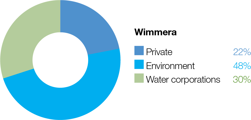
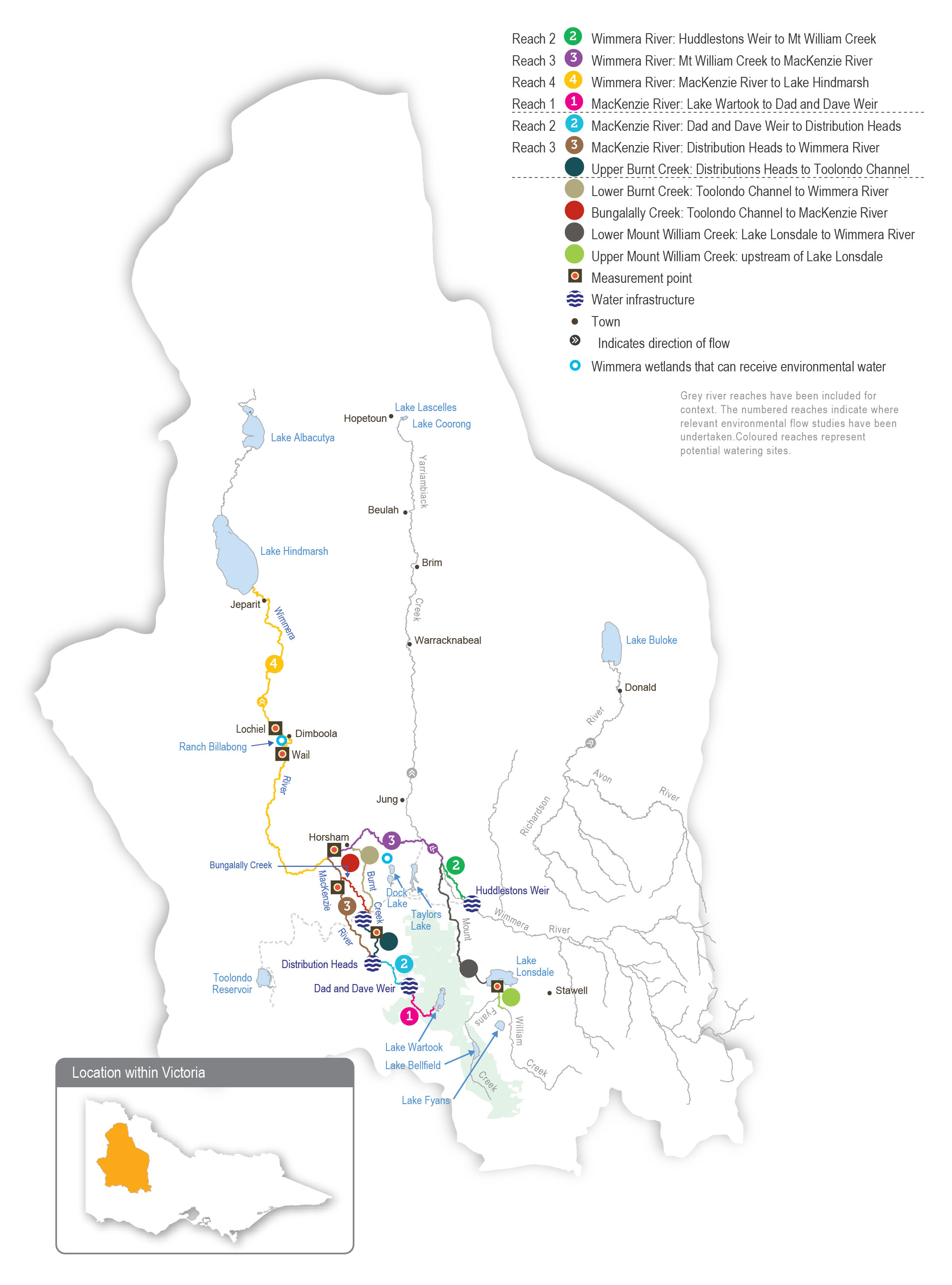
Wimmera River (reach 4)

Winter/spring low flows (30 ML/day during June to November)

Kayak iconsFishing icon

  • Maintain access to habitat for native fish, waterbugs and in-stream vegetation

Fish iconInsect iconPlant icon

Small winter/spring fresh(es) (one to five freshes of 70 ML/day for one to five days during June to November)

Kayak iconsFishing icon

  • Increase water depth to provide a stimulus for fish movement
  • Provide flow variability to maintain water quality and diversity of fish habitats

Fish iconWater drop icon

Medium winter/spring fresh(es) (one to three freshes of 200 ML/ day for one to three days during June to November)

  • Provide variable flow during the high-flow season for fish movement
  • Provide flow variability to maintain water quality and diversity of fish habitats
  • Wet lower benches, entrain organic debris and maintain habitat for waterbugs and fish

Fish iconInsect iconWater drop iconPlant icon

Summer/autumn low flow (15 ML/day or natural during December to May)

Kayak iconsFishing icon
  • Maintain edge habitats in deeper pools and in-stream habitat to support native fish populations and waterbugs
  • Maintain soil moisture for streamside vegetation and near-permanent inundated stream channel for aquatic vegetation and prevent the growth of terrestrial plants in the stream bed

Fish iconInsect iconPlant icon

Summer/autumn fresh(es) (one to three freshes of 70 ML/day for two to seven days during December to May)

Kayak iconsFishing icon
  • Flush pools to prevent a decline in water quality and to maintain habitat for fish and waterbug
  • Provide fish passage to allow fish to move through the reach

Fish iconInsect iconWater drop icon

MacKenzie River (reach 3)

Winter/spring low flow (10 ML/day or natural)

  • Maintain edge habitats and deeper pools and runs for waterbugs and platypus
  • Maintain soil moisture for streamside vegetation and near-permanent inundated stream channel for aquatic vegetation and prevent the growth of terrestrial plants in the stream bed
  • Maintain pool habitat for native fish and crayfish populations

Fish iconPlatypus iconInsect iconPlant icon

Winter/spring fresh(es) (five freshes of 35 ML/ day for two to seven days during June to November)

  • Stimulate fish movement by increasing flow rates and water depth and increase habitat availability for platypus and waterbugs
  • Flush pools to prevent a decline in water quality
  • Maintain soil moisture for streamside vegetation

Fish iconPlatypus iconPlant iconInsect iconWater drop icon

Summer/autumn low flow (10 ML/day or natural)

  • Maintain edge habitats and deeper pools and runs for waterbugs and platypus
  • Maintain soil moisture for streamside vegetation and near-permanent inundated stream channel for aquatic vegetation and prevent the growth of terrestrial plants in the stream bed
  • Maintain pool habitat for native fish and crayfish populations

Fish iconPlatypus iconInsect iconPlant icon

Summer/autumn freshes (three to four freshes of 35 ML/day for two to seven days each during December to May)

  • Flush pools to prevent a decline in water quality and to increase habitat availability for waterbugs and native fish

Fish iconInsect iconWater drop icon

Upper Burnt Creek

Winter/spring low flow (1 ML/day or natural, year-round)

  • Maintain edge habitats and shallow-water habitat for waterbugs
  • Maintain soil moisture for streamside vegetation and near-permanent inundated stream channel for aquatic vegetation and prevent the growth of terrestrial plants in the stream bed
  • Maintain a sufficient area of pool habitat for native fish and crayfish populations

Fish iconPlant iconInsect icon

Winter/spring fresh(es) (one to five freshes of 55 ML/day for three to seven days during June to November)

  • Allow fish to move throughout the reach
  • Flush sediments from hard substrates to increase biofilm production and food for waterbugs
Fish iconInsect icon

Summer/autumn low flow (1 ML/day or natural, year-round)

  • Maintain edge habitats and shallow-water habitat for waterbugs
  • Maintain soil moisture for streamside vegetation and near-permanent inundated stream channel for aquatic vegetation and prevent the growth of terrestrial plants in the stream bed
  • Maintain a sufficient area of pool habitat for native fish and crayfish populations

Fish iconPlant iconInsect icon

Summer/autumn freshes (three freshes of 30 ML/ day for two to seven days each during December to May)
  • Prevent a decline in water quality by flushing pools in the low-flow season
  • Allow fish to move throughout the reach
  • Flush sediments from hard substrates to increase biofilm production and food for waterbugs

Fish iconInsect iconWater drop icon

Lower Burnt Creek

Bankfull fresh (one fresh of 45 ML/day for two days at any time)

  • Inundate streamside vegetation to maintain plant condition and facilitate recruitment
  • Move organic debris in the channel to support waterbugs
  • Maintain the structural integrity of the channel

Plant iconMountain iconsInsect icon

Overbank fresh (one fresh of 90 ML/day for one day during August to November)

  • Inundate floodplain vegetation to maintain plant condition and facilitate recruitment
  • Move organic debris from the floodplain to support waterbugs in the channel
  • Maintain the structural integrity of the channel and floodplain

Plant iconMountain iconsInsect icon

Bungalally Creek

Bankfull fresh (one fresh of 60 ML/day for two days at any time)

  • Inundate the streamside zone to maintain its condition and facilitate the recruitment of streamside vegetation communities
  • Maintain the structural integrity of the channel and prevent the loss of channel capacity

Mountain iconsPlant icon

Upper Mount William Creek
Top-up of pools (summer/autumn)
  • Maintain edge and shallow-water habitat for native fish and waterbugs
  • Maintain water quality

Fish iconInsect iconWater drop icon

Lower Mount William Creek
Year-round low flow (5 ML/day or natural)
  • Maintain edge habitats and shallow-water habitat for waterbugs and endemic fish
  • Maintain soil moisture for streamside vegetation and near-permanent inundated stream channel for aquatic vegetation and prevent the growth of terrestrial plants in the stream bed

Fish iconInsect iconPlant icon

Winter/spring fresh(es) (one to five freshes of 100 ML/day for one to seven days during June to November)

  • Wet benches to entrain organic debris and allow native fish to move throughout the reach
  • Flush surface sediments from hard substrates to support waterbugs
  • Inundate the streamside zone to maintain its condition and facilitate the recruitment of streamside vegetation communities

Fish iconInsect iconPlant icon

Summer/autumn freshes (three freshes of 20-30 ML/day for two to seven days during December to May)
  • Prevent a decline in water quality by flushing pools during low flow
  • Provide variable flows and allow the movement of fish and waterbugs throughout the reach during the low-flow season

Fish iconInsect iconWater drop icon

Dock Lake
Winter/spring partial fill
  • Trigger the growth and germination of wet-phase wetland vegetation communities
  • Support feeding and breeding habitat for waterbirds, frogs, waterbugs and turtles

Frog iconTurtle iconsPlant iconBird iconInsect icon

Ranch Billabong

Top-ups (winter/spring and summer/autumn)

Billabong icon
  • Inundate wetland vegetation to maintain plant condition and facilitate recruitment
  • Improve water quality for frogs and waterbirds

Frog iconPlant iconBird icon

Scenario planning

Table 4.3.2 outlines potential environmental watering and expected water use under a range of planning scenarios.

In the Wimmera system, water for the environment is delivered to support specific ecological objectives in the different rivers and creeks. If dry conditions continue in the Wimmera system, the nature of deliveries of water for the environment to individual reaches will likely be influenced by water availability in the storages directly above each target reach. This is

especially true for the MacKenzie River, Bungalally Creek and Burnt Creek (that rely on water from Lake Wartook and Moora Moora Reservoir) and for lower Mount William Creek (which relies on water from Lake Lonsdale).

Wimmera River

The highest-priority potential watering actions in the Wimmera River under all climate scenarios are winter/spring and summer/ autumn low flows. These actions are vital to maintaining water levels and water quality in refuge pool habitat for native fish.

Under the driest scenarios, low flows will be delivered intermittently and at lower magnitudes due to low water availability. The primary objective under drought and very dry conditions will be to minimise the loss of aquatic plants and animals. In a dry scenario, there should be enough water to deliver low flows for part of each season and some small freshes to mitigate

elevated salinity and maintain the current condition of native fish populations. Under average and wet climate scenarios, there should be enough environmental flow and natural catchment flow to deliver continuous low flow throughout each season, as well as some larger, longer-duration freshes to boost the ecological health of the river.

MacKenzie River/Burnt Creek/Bungalally Creek

In the MacKenzie River and Burnt Creek, under drought and dry climate scenarios, the highest priority will be to deliver small volumes of water to critical drought refuges in Burnt Creek and reach 3 of the MacKenzie River. Such flows are vital to protect populations of native fish, platypus and crayfish that have re-established since the Millennium Drought. Under drought to dry scenarios, low flows will be delivered for as long as possible, and freshes may be delivered at less than the target magnitudes to maintain critical habitats while conserving water. Under average and wet conditions, water for the environment will be used to increase flowing habitat in both systems and deliver more frequent freshes in the MacKenzie River, to improve the health of aquatic and emergent vegetation and native fish communities. Maintaining the connection between reach 3 of the MacKenzie River and the Wimmera River is a high priority under average and wet climate scenarios to allow fish to move between the two systems, thereby growing the populations and increasing their genetic diversity. Watering actions for reach 3 of the MacKenzie River typically provide suitable flows to meet objectives in reach 2, but if extremely dry conditions prevent deliveries to reach 3, then small volumes will be delivered in reach 2 to support populations of sensitive species, including river blackfish.

A bankfull flow may be delivered to Bungalally Creek and Burnt Creek under average and wet climate scenarios to improve the health of streamside vegetation. This flow can only be delivered during periods of high flow throughout the system, so it is not considered under drier climate scenarios.

Mount William Creek

Poor water quality (in particular high salinity levels) and low water availability in Lake Lonsdale are likely to prevent the achievement of most recommended watering actions in lower Mount William Creek under drought and very dry climate scenarios. Any available water under these scenarios will be used to deliver low flows for as long as possible and small freshes to the section of lower Mount William Creek near the lake outlet. Water from Lake Fyans may be used to top up refuge pools immediately upstream of Lake Lonsdale (upper Mount William Creek) to improve water quality and habitat availability for native fish populations. Increased water availability under average or wet climate scenarios will be used to deliver a mix of low flows and freshes through the whole lower Mount William Creek system and connect it to the Wimmera River. These larger flows are necessary to allow small-bodied native fish to disperse, to help recover populations that have been affected by multiple years of below-average flow and extended cease-to-flow conditions.

Ranch Billabong and Dock Lake

Under all climatic conditions, small top-ups are planned to inundate Ranch Billabong to improve water quality and support the ongoing recovery of the river red gum and associated understorey vegetation surrounding the billabong. Environmental flow objectives for Dock Lake require large volumes of water that can only be achieved with significant contributions from natural events, so delivering water for the environment is only a priority at Dock Lake under wet conditions.

Reserving water for carryover into the 2023-24 water year is a priority under all scenarios. Carryover is vital to ensure sufficient water to deliver the highest-priority flows during summer and autumn 2023-24 if there are low allocations during the year. A range of scenarios has been discussed for carryover targets under the Wimmera and Glenelg rivers environmental entitlement. The VEWH will consult with the Wimmera and Glenelg Hopkins CMAs during the season and set a final target when there is sufficient information to do so. The target carryover volume for 30 June 2023 will be based on use during 2022- 23, environmental conditions and seasonal outlooks for 2023-24.

Planning scenario table

Table 4.3.2 Potential environmental watering for the Wimmera system under a range of planning scenarios

Planning scenario

Drought

Very dry

Dry

Average

Wet

Expected river conditions

  • Infrequent, unregulated flow for reach 2 of the MacKenzie River, upper Burnt Creek and lower Mt William Creek
  • Regulated releases provide flows at other times and locations
  • Periodic, unregulated flow for reach 2 of the MacKenzie River, upper Burnt Creek and lower Mt William Creek
  • Regulated releases provide flows at other times and locations
  • Periodic, unregulated flow for reach 2 of the MacKenzie River, upper Burnt Creek and lower Mt William Creek
  • Regulated releases provide flows at other times and locations, apart from modest passing flow
  • Regular, unregulated flow for reach 2 of the MacKenzie River, upper Burnt Creek and lower Mt William Creek
  • Reasonable passing flow and unregulated releases for the Wimmera River and lower Mt William Creek
  • Regulated releases provide flows at other times and locations
  • Regular, unregulated flow for reach 2 of the MacKenzie River, upper Burnt Creek and lower Mt William Creek
  • Frequent passing flow and unregulated releases for the Wimmera River and lower Mt William Creek
  • Regulated releases provide flows at other times and locations

Predicted supply of water for the environment1

  • 25,400 ML
  • 32,300 ML
  • 43,500 ML
  • 54,600 ML
  • 64,800 ML

Wimmera River (targeting reach 4)

Potential environmental watering – tier 1 (high priorities)

Tier 1a (can be achieved with predicted supply)

  • Winter/spring low flow (one month)
  • Summer/ autumn low flow (one month)
  • Winter/spring low flow (one month)
  • Summer/ autumn low flow (two months)
  • Winter/spring low flow (two months)
  • Small winter/ spring fresh (one fresh)
  • Summer/ autumn low flow (three months)
  • Summer/ autumn freshes (two freshes)
  • Winter/spring low flow (four months)
  • Small winter/ spring freshes (three freshes)
  • Summer/ autumn low flow (four months)
  • Summer/ autumn freshes (two freshes)
  • Winter/spring low flow (four months)
  • Small winter/ spring freshes (three freshes)
  • Medium winter/ spring freshes (two freshes)
  • Summer/ autumn low flow (four months)
  • Summer/ autumn freshes (three freshes)

Tier 1b (supply deficit)

  • Winter/spring low flow (increased duration)
  • Small winter/ spring fresh (one fresh)
  • Summer/ autumn low flow (increased duration)
  • Summer/ autumn fresh (one fresh)
  • Winter/spring low flow (increased duration)
  • Small winter/ spring fresh (one fresh)
  • Summer/ autumn low flow (increased duration)
  • Summer/ autumn fresh (one fresh)
  • Winter/spring low flow (increased duration)
  • Small winter/ spring freshes (three freshes)
  • Medium winter/ spring freshes (two freshes)
  • Summer/ autumn low flow (increased duration)
  • Winter/spring low flow (increased duration)
  • Small winter/ spring freshes (five freshes)
  • Medium winter/ spring freshes (two freshes)
  • Summer/ autumn low flow (increased duration)
  • Winter/spring low flow (increased duration)
  • Small winter/ spring freshes (two freshes)
  • Medium winter/ spring fresh (one fresh)
  • Summer/ autumn low flow (increased duration)
  • Summer/ autumn freshes (two freshes)

MacKenzie River (targeting reach 3)2

Potential environmental watering – tier 1 (high priorities)

Tier 1a (can be achieved with predicted supply)

  • Winter/spring low flow (one month)
  • Summer/ autumn low flow (one month)
  • Summer/ autumn freshes (four freshes)
  • Winter/spring low flow (two months)
  • Summer/ autumn low flow (one month)
  • Summer/ autumn freshes (four freshes)
  • Winter/spring low flow (two months)
  • Summer/ autumn low flow (two months)
  • Summer/ autumn freshes (four freshes)
  • Winter/spring low flow (four months)
  • Winter/spring fresh (one fresh)
  • Summer/ autumn low flow (four months)
  • Winter/spring low flow (four months)
  • Winter/spring fresh (one fresh)
  • Summer/ autumn low flow (four months)
  • Summer/ autumn fresh (one fresh)

Tier 1b (supply deficit)

  • Winter/spring low flow (increased duration)
  • Winter/spring freshes (five freshes)
  • Summer/ autumn low flow (increased duration)
  • Summer/ autumn freshes (three freshes, full magnitude)
  • Winter/spring low flow (increased duration)
  • Winter/spring freshes (five freshes)
  • Summer/ autumn low flow (increased duration)
  • Summer/ autumn freshes (three freshes, full magnitude)
  • Winter/spring low flow (increased duration)
  • Winter/spring freshes (five freshes)
  • Summer/ autumn low flow (increased duration)
  • Summer/ autumn freshes (three freshes, full magnitude)
  • Winter/spring low flow (increased duration)
  • Winter/spring freshes (five freshes)
  • Summer/ autumn low flow (increased duration)
  • Summer/ autumn freshes (four freshes)
  • Winter/spring low flow (increased duration)
  • Winter/spring freshes (five freshes)
  • Summer/ autumn low flow (increased duration)
  • Summer/ autumn freshes (four freshes)

Upper Burnt Creek

Potential environmental watering – tier 1 (high priorities)

Tier 1a (can be achieved with predicted supply)

  • Winter/spring low flow (one month)
  • Summer/ autumn low flow (four months)
  • Winter/spring low flow (one month)
  • Summer/ autumn low flow (four months)
  • Winter/spring low flow (one month)
  • Summer/ autumn low flow (four months)
  • Winter/spring low flow
  • Winter/spring freshes (five freshes, small)
  • Summer/ autumn low flow (four months)
  • Winter/spring low flow
  • Winter/spring freshes (five freshes, small)
  • Summer/ autumn low flow (four months)

Tier 1b (supply deficit)

  • Winter/spring low flow (increased duration)
  • Winter/spring fresh (one fresh, small)
  • Summer/ autumn low flow (increased duration)
  • Summer/ autumn freshes (three freshes)
  • Winter/spring low flow (increased duration)
  • Winter/spring freshes (two freshes, small)
  • Summer/ autumn low flow (increased duration)
  • Summer/ autumn freshes (three freshes)
  • Winter/spring low flow (increased duration)
  • Winter/spring freshes (three freshes, small)
  • Summer/ autumn low flow (increased duration)
  • Summer/ autumn freshes (three freshes)
  • Summer/ autumn low flow (increased duration)
  • Summer/ autumn freshes (three freshes)
  • Summer/ autumn low flow (increased duration)
  • Summer/ autumn freshes (three freshes)

Lower Burnt Creek

Potential environmental watering – tier 1 (high priorities)

Tier 1a (can be achieved with predicted supply)

  • N/A
  • Bankfull fresh

Bungalally Creek

Potential environmental watering – tier 1 (high priorities)

Tier 1a (can be achieved with predicted supply)

  • N/A
  • Bankfull fresh

Upper Mount William Creek

Potential environmental watering – tier 1 (high priorities)

Tier 1a (can be achieved with predicted supply)

  • Top-ups

Lower Mount William Creek

Potential environmental watering – tier 1 (high priorities)

Tier 1a (can be achieved with predicted supply)

  • N/A
  • Year-round low flow
  • Summer/ autumn freshes (three freshes)
  • Year-round low flow
  • Winter/spring fresh (one fresh)
  • Summer/ autumn freshes (three freshes)

Potential environmental watering – tier 1 (high priorities)

Tier 1b (supply deficit)

  • Year-round low flow
  • Summer/ autumn freshes (three freshes)
  • Year-round low flow
  • Summer/ autumn freshes (three freshes)
  • Year-round low flow
  • Summer/ autumn freshes (three freshes)
  • Year-round low flow (increased duration)
  • Summer/ autumn freshes (increased duration)
  • Year-round low flow (increased duration)
  • Winter/spring freshes (four freshes)
  • Summer/ autumn freshes (increased duration)

Dock Lake

Potential environmental watering – tier 1 (high priorities)

Tier 1a (can be achieved with predicted supply)

  • N/A
  • Winter/spring Partial fill

Ranch Billabong

Potential environmental watering – tier 1 (high priorities)

Tier 1a (can be achieved with predicted supply)

  • Top-ups (winter/spring and summer/autumn) (one winter and one autumn top-up after drawing down if needed)

Possible volume of water for the environment required

to achieve objectives

  • 6,990 ML (tier 1a)
  • 29,560 ML (tier 1b)
  • 7,990 ML (tier 1a)
  • 28,560 ML (tier 1b)
  • 11,490 ML (tier 1a)
  • 26,440 ML (tier 1b)
  • 16,490 ML (tier 1a)
  • 21,370 ML (tier 1b)
  • 21,490 ML (tier 1a)
  • 24,570 ML (tier 1b)

Priority carryover requirements1

  • 14,000 ML
  • 19,000 ML
  • 23,000 ML
  • 28,000 ML
  • 32,000 ML

1 Volume applies to the shared Wimmera and Glenelg Rivers Environmental Entitlement 2010.
2 Potential watering actions ta rgeting reach 3 of the MacKenzie River will also benefit reach 2.

Engagement

Table 2 shows the partners and stakeholder organisations with which Wimmera CMA engaged when preparing the Wimmera system seasonal watering proposal. Other stakeholders and individuals are consulted throughout the year to help the Wimmera CMA implement the seasonal watering plan.

Seasonal watering proposals are informed by longer-term regional catchment strategies, regional waterway strategies, environmental flow studies, water management plans and other studies. These incorporate a range of environmental, cultural, social and economic perspectives and longerterm integrated catchment and waterway management objectives. For further details, refer to the Wimmera Regional Catchment Strategy and the Wimmera Waterway Strategy.

Wimmera CMA holds its annual Environmental Water Management Forum, where community groups and agencies with an interest in water for the environment in the region provide feedback about the effectiveness of environmental watering, drought actions and other issues.

Table 2 Partners and stakeholders engaged in developing the Wimmera system seasonal watering proposal

Partner and stakeholder engagement
  • Yarriambiack Creek Advisory Committee
  • Friends of Bungalally and Burnt Creek
  • Commonwealth Environmental Water Office
  • Department of Environment, Land, Water and Planning – Grampians Region
  • Glenelg Hopkins CMA
  • Grampians Wimmera Mallee Water
  • Hindmarsh Shire Council
  • Horsham Rural City Council
  • Northern Grampians Shire Council
  • Parks Victoria
  • Victorian Fisheries Authority
  • Yarriambiack Shire Council
  • Wimmera community members, especially landholders
  • Natimuk and District Field and Game
  • VRFish
  • Natimuk Lake Water Ski Club
  • Dimboola Water Ski Club
  • Dimboola Fishing Classic
  • Horsham Triathlon Committee
  • Wimmera Anglers’ Association
  • Dimboola Rowing Club
  • Jeparit Anglers’ Club
  • Hindmarsh Ski Club
  • Horsham Fishing Competition Committee
  • Canoeing Victoria
  • Arthur Rylah Institute (Department of Environment, Land, Water and Planning)
  • Barengi Gadjin Land Council

Page last updated: 01/07/22